
1777 Brion de La Tour Map of New York and New England (Revolutionary War)

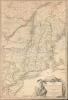

Carte du Theatre de la Guerre entre les Anglais et Les Americains.
Foundational cartographic document of Saratoga, the Franco-American alliance, and the transformation of the American Revolution into a global war.
- Digital Map Information
- Suitable for large format printing
- Full resolution TIFF file
- ICC color profile embedded
- Delivered instantly via download link
Foundational cartographic document of Saratoga, the Franco-American alliance, and the transformation of the American Revolution into a global war.
This is the rare first edition of Louis Brion de la Tour's significant 1777 map of the northern theater of the American Revolutionary War. Published in Paris in the immediate aftermath of the American victory at Saratoga and the surrender of General John Burgoyne's army, it is the first published illustration of the Battle of Saratoga to appear in France. The map brought French audiences cartographic news of the victory that transformed the course of the Revolution, helping convince France that the American cause was viable and setting the stage for the Franco-American alliance of 1778. As such, it captures a pivotal moment when an American colonial rebellion was becoming an international war.A Closer Look
The map encompasses the principal northern theater of the conflict, extending from the Delaware and Chesapeake Bays northward to Quebec City. It embraces New York (including modern-day Vermont), New Jersey, Massachusetts, Connecticut, New Hampshire, and portions of Pennsylvania, Maryland, Delaware, Maine, and Canada. Brion presents sophisticated political and topographical detail, identifying mountains, rivers, roads, colonial boundaries, American Indian nations, towns, and cities.The geographical underpinnings of Brion's map trace to authoritative British cartography published just before the Revolution. For New England, Brion drew particularly upon the 1776 Sayer and Bennett edition of Thomas Jefferys' A Map of the most Inhabited part of New England. His treatment of New York, New Jersey, and the surrounding region similarly derives from the Jefferys / Samuel Holland The Provinces of New York, and New Jersey; with part of Pensilvania, and the Province of Quebec, also issued by Sayer and Bennett in 1776. Brion thus adapted some of the finest contemporary British mapping of the colonies, transforming it into a distinctly French record of the rapidly changing military situation in North America.
Most important are Brion's topical additions relating to the Saratoga campaign and the surrender of Lieutenant General John Burgoyne's British army on October 17, 1777. Burgoyne had advanced south from Canada with a large force of British and German troops as part of an ambitious campaign intended to seize the Hudson River corridor and isolate New England from the other rebellious colonies. Instead, following the Battles of Saratoga at Freeman's Farm and Bemis Heights, American forces under Horatio Gates (1727 - 1806), with Benedict Arnold (1741 - 1801) playing a critical battlefield role, surrounded Burgoyne's depleted army and compelled its surrender.
Saratoga and France
The American victory at Saratoga transformed the Revolution. News of Burgoyne's surrender reached a France already sympathetic to the American cause and provided compelling evidence that the rebellion had a realistic prospect of military success. The government of Louis XVI (1754 - 1793) formally recognized the United States and concluded treaties of alliance and commerce with the Americans in February 1778, bringing France openly into the war against Britain. Spain subsequently entered the conflict against Britain in 1779. What had begun as a rebellion within the British Empire thus expanded into a global conflict fought in North America, the Caribbean, Europe, Africa, and Asia.Brion's map is particularly important in this context. As the first published illustration of the Battle of Saratoga to appear in France, it represents the extraordinary speed with which news of the American victory entered French public consciousness. It appeared as French interest in the Revolution reached a critical point and just before France's formal commitment to the American cause.
Publication History and Census
Brion's map was separately issued by Louis Brion de la Tour and published by Esnauts and Rapilly from their establishment on the Rue Saint-Jacques, at the sign of the Ville de Coutances, Paris. This example is the first edition, published in 1777. Further editions followed in 1778 and 1779, with a reduced version appearing in 1782. Of these, the 1777 first edition is the most historically significant, having been issued in direct response to the Saratoga campaign and Burgoyne's surrender.OCLC and institutional catalog records identify at least ten physical examples of the 1777 first edition, held by the Library of Congress; Boston Public Library; New York Public Library; University of Michigan's William L. Clements Library; Harvard University; Society of the Cincinnati Library; Staatsbibliothek zu Berlin; Bibliothèque interuniversitaire de la Sorbonne; and two examples at the Bibliothèque nationale de France, including one in the Bibliothèque de l'Arsenal (EST-1504 (15)).
Cartographers
Louis Brion de la Tour (1743 - 1803) was the Cartographer Royal to the King of France, his official title being Ingenieur-Geographe du Roi. Despite a prolific cartographic career and several important atlases to his name, little is actually known of his life and career. He may have been born in Bordeaux. His son of the same name was born in 1763 and published until his death in 1832. It is nearly impossible to distinguish the work of the father from the work of the son, as both used the same imprint and were active in roughly the same period. Much of their work was published in partnership Louis Charles Desnos (fl. 1750 - 1790). Their most notable work is generally regarded to be his 1766 Atlas General. Further Details...
Esnauts and Rapilly (fl. c. 1775 - 1811) were Paris based print sellers and publishers active in the latter part of the 18th century. The firm was founded by Jacques Esnauts and Michel Rapilly. Esnauts and Rapilly are best known not for their cartographic works, but rather for their fashion prints. The important publication La Galerie des Modes highlighted the fashions of the French aristocracy just prior to the French Revolution and is considered to be the first published "fashion magazine". At this time, Paris was the center of the fashion world and Esnauts and Rapilly's plates were widely distributed to eager fashionistas the world over. The firm also published a number of important and influential maps including several depicting pivotal moments in the American Revolutionary War. Not wanting to miss out on potential customers, Esnauts and Rapilly gave exact directions to their bookshop on many of their publications: "at the Baker's shop, opposite the Cutler." Further Details...
Condition
Very good. Top and bottom margins extended. Toning, with slightly more at top. Minor discoloration, likely a printing flaw, near Biddeford (Beddiford), Maine.
References
OCLC 244673854, 1252307866. McCorkle, B. B., New England in Early Printed Maps 1513-1800: An Illustrated Carto-Bibliography, #777.6. Nebenzahl, Kenneth, A Bibliography of Printed Battle Plans of the American Revolution, 1775-1795, #121. Library of Congress, Map Division, G3710 1777.B71 Vault. Sellers, J. R., and Van Ee, P. M., Maps and Charts of North America and the West Indies 1750-1789, #728.