
Esnauts and Rapilly

Esnauts and Rapilly (fl. c. 1775 - 1811) were Paris based print sellers and publishers active in the latter part of the 18th century. The firm was founded by Jacques Esnauts and Michel Rapilly. Esnauts and Rapilly are best known not for their cartographic works, but rather for their fashion prints. The important publication La Galerie des Modes highlighted the fashions of the French aristocracy just prior to the French Revolution and is considered to be the first published "fashion magazine". At this time, Paris was the center of the fashion world and Esnauts and Rapilly's plates were widely distributed to eager fashionistas the world over. The firm also published a number of important and influential maps including several depicting pivotal moments in the American Revolutionary War. Not wanting to miss out on potential customers, Esnauts and Rapilly gave exact directions to their bookshop on many of their publications: "at the Baker's shop, opposite the Cutler."
Part of the worldwide conflict triggered by the American Revolutionary War.
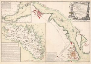
Théâtre de la Guerre sur la Mer Méditerranée comprennant l'Invasion de l'Isle Minorque par l'Armée Espagnole aux Ordres du Duc de Crillon le 19 Aoust 1781 avec les Plans du Port Mahon, du Fort S. Philippe, une Partie des Côtes d'Espagne, de Barbarie et du Détroit de Gibraltar.
$2,100.00
Acquire
- Digital Map Information
- Suitable for large format printing
- DPI: 600
- File Size: 83.01 MB
- File Type: ZIP / TIFF
- ICC color profile embedded
- Delivered instantly via download link
This is a 1781 Louis Brion de la Tour map of Menorca illustrating the 1781 Franco-Spanish invasion of Menorca. The map marks the end of roughly 20 years of British control of Menorca and the return of the island to Spanish sovereignty. (more details)