This item has been sold, but you can get on the Waitlist to be notified if another example becomes available, or purchase a digital scan.
1855 Osborne Wall Map of Thomaston, Maine
ThomastonMaine-osborne-1855$1,250.00


Title
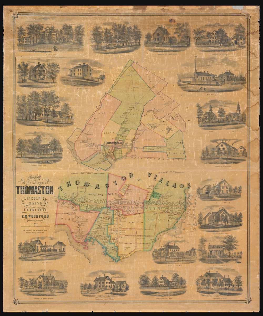
Map of the Town of Thomaston Lincoln Co. Maine.
1855 (dated) 46 x 38.25 in (116.84 x 97.155 cm)
1855 (dated) 46 x 38.25 in (116.84 x 97.155 cm)
Description
A charming and rare 1855 map of Thomaston, a town in the Penobscot Bay region of mid-coast Maine. The map is divided into two sections. The upper map details greater Thomaston area. The lower map is a detail of Thomaston Village. Exceptional detail offering interesting insights throughout. When this map was issued, Thomaston was a prosperous port and ship building center. Pay particular attention to the kilns, shipyards and wharves shown along the Mill River and at the head of the bay. In 1840, not long before this map was issued, two of seven recorded millionaires in the United States were Thomaston sea captains - a fact that illustrates Thomaston's historical wealth. Both maps are surrounded by vignette images of important residences, many of which still stand. The Knox Mansion, appearing in the upper left, was at the time the grandest home in Maine and is today a museum.
Publication History and Census
The map is based upon surveys compiled by D. S. Osborne. It was published in Philadelphia by E. M Woodford and printed by 'Friend and Aub', Lithographers, at 80 Walnut Street, Philadelphia.Cartographer
Edgar Maurice Woodford (April 15, 1824 – October 1, 1862) was a mid-19th century American abolitionist, civil engineer, surveyor, and map publisher active in New England. Woodford was born on his family farm in Avon, Connecticut. Although self-taught as a surveyor, he rose to become the official Hartford County surveyor. He was described by a nephew as 'a great strapping man,' who would come 'over the hills with his [surveying] instruments over his shoulder, crying for fear his work would not come out right.' Woodford produced numerous county surveys in Connecticut, Maine, and Massachusetts. Typically Woodford worked with other cartographers, but from time to time, he published independently, including his maps of Belfast and Frankfort, Maine, as well as Belknap, New Hampshire. As an abolitionist Woodford was part of the 1856 'Connecticut Colony in Kansas,' an attempt to colonize Kansas with enough abolitionist New Englanders to sway the vote and force Kansas to enter the Union as a Free State. When the Civil War broke out he enlisted in the Seventh Connecticut Volunteer Infantry, where he was assigned the rank of Quartermaster. It was during the war when he passed away in Hilton Head Island, South Carolina, of 'congestive fever,' an archaic term for malaria. He is interred in the soldiers cemetery at Hilton Head. More by this mapmaker...
Condition
Good. Unrestored. Some reinforcement along the top, where the map exhibits flaking. Would restore beautifully.