This item has been sold, but you can get on the Waitlist to be notified if another example becomes available, or purchase a digital scan.
1946 Tilp Pictorial Map of the Potomac from Washington, D.C. to Maryland
TidewaterPotomac-tilp-1946$150.00

Title
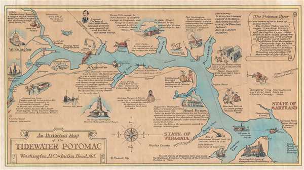
An Historical Map of the Tidewater Potomac Washington, D.C. to Indian Head, Md.
1946 (undated) 9 x 16.25 in (22.86 x 41.275 cm) 1 : 86000
1946 (undated) 9 x 16.25 in (22.86 x 41.275 cm) 1 : 86000
Description
This is a 1946 Frederick Tilp map of the Potomac River. The map depicts the river and its environs from Washington, D.C. and Georgetown University to Indian Head, Maryland. Charmingly illustrated, several morsels of information concerning American history in the region are provided. The earliest tidbit presents the fact that Moyaone, a Native American village on or near the river, was noted on Captain John Smith's map in 1608. Several locations within Washington, D.C. are labeled, including the Naval Research Laboratory, Bolling Field Army Aire Base, the naval air station, and Georgetown University, complete with a vignette of the clock tower on Healy Hall. A wonderful illustration of the U.S. Capitol is situated along the left border. Other information provided on the map concerns events during the French and Indian War, the American Revolution, the War of 1812, and the American Civil War.
This map was created by Frederick Tilp and published in 1946.
This map was created by Frederick Tilp and published in 1946.
Cartographer
Frederick Tilp (1908 - 1988) was an historian born in Bladensburg, Maryland. He is best known for the 1978 classic This Was Potomac River More by this mapmaker...
Condition
Very good. Even overall toning. Blank on verso.
References
OCLC 21905090.