This item has been sold, but you can get on the Waitlist to be notified if another example becomes available, or purchase a digital scan.
1949 Marino Map of Yellowstone National Park and Vicinity
TopOfWorldYellowstone-marino-1949$87.50

Title
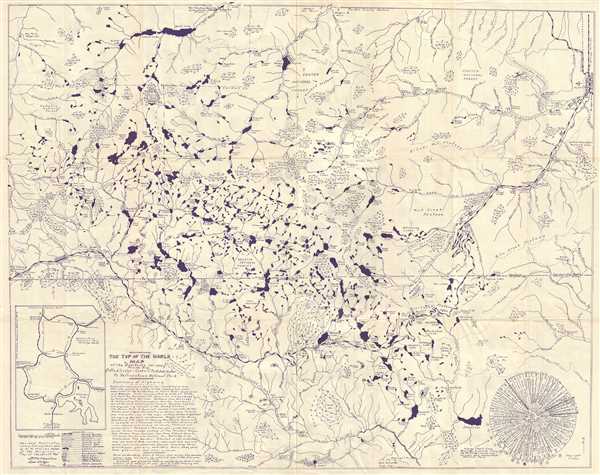
The Top of the World Map of the Beartooth Hi-way Route 212 Via Red Lodge - Cooke City - Silver Gate to Yellowstone National Park.
1949 (undated) 27 x 33.5 in (68.58 x 85.09 cm) 1 : 78000
1949 (undated) 27 x 33.5 in (68.58 x 85.09 cm) 1 : 78000
Description
This is an attractive c.1949 Marino Map of the Yellowstone National Park and vicinity. It covers from Swamp Lake and Deep Lake in Northeast Wyoming north as far as Mystic Lake in Custer Gallatin National Forest in Montana. Beautifully detailed, the map notes roads, trails, lakes, rivers, glaciers, swamps, campsites, scenic spots, peaks, etc. An inset in the lower left quadrant features a road map of the area.
Primarily drawn to feature the Beartooth highway Route 212 via Red Lodge – Cooke City – Silver Gate to Yellowstone National Park, the map includes a mileage chart from Red Lodge to points along the Red Lodge – Cooke City highway and Yellowstone National Park.
A summary of the highway below the title describes the route and the various sites and includes a word of caution. This revised publication was compiled and published by D. M. Marino, author of the original ‘Top of the World Map’.
Condition
Very good. Minor wear and toning along original fold lines. Verso repair over fold intersections. Minor edge wear and foxing.