This item has been sold, but you can get on the Waitlist to be notified if another example becomes available, or purchase a digital scan.
1905 Johnston Plan of Toronto, Canada
Toronto-johnston-1905$200.00


Title
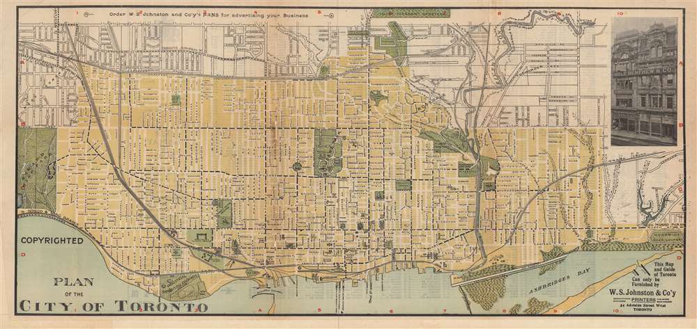
Plan of the City of Toronto.
1905 (undated) 10.5 x 22.5 in (26.67 x 57.15 cm) 1 : 24000
1905 (undated) 10.5 x 22.5 in (26.67 x 57.15 cm) 1 : 24000
Description
This is a rare c. 1905 map or plan of Toronto, Canada, produced by W.S. Johnston and Company. It depicts the city following breakneck expansion in the late 19th century, as it incorporated and filled in surrounding communities.
Though not denoted by a legend, dashed lines refer to streetcar lines. As for railways, the Union Station present here had replaced an earlier, smaller station near the same site, but was itself replaced with the current structure of the same name, located just to the west, which opened in 1927. A large fire in 1904 centered around Wellington West and Bay Streets destroyed much of the downtown portion of the city, at bottom-center. The area was quickly rebuilt, including early skyscrapers, setting off a boom of tall buildings in the city.
Toronto grew quickly in the second half of the 19th century, with the population sextupling between 1851 and 1891. Large numbers of immigrants came from Ireland and divisions between Irish Protestants and Catholics became a defining feature of local politics. Additional immigrants, including a significant Jewish population, came from elsewhere in Europe, along with a contingent of Chinese. The city also grew in area over this period, incorporating nearby suburbs (referred to with annexed and extended streets on the verso).
A Closer Look
This map is oriented towards the northwest to make the straight waterfront of Toronto align with the bottom border. A grid surrounds the map, corresponding to an index of street names on the verso. The city itself is shaded yellow while suburbs remain unshaded, with parks and cemeteries colored green. Notable landmarks are indicated, such as the roughly coterminous University of Toronto and Queen's Park at center.Though not denoted by a legend, dashed lines refer to streetcar lines. As for railways, the Union Station present here had replaced an earlier, smaller station near the same site, but was itself replaced with the current structure of the same name, located just to the west, which opened in 1927. A large fire in 1904 centered around Wellington West and Bay Streets destroyed much of the downtown portion of the city, at bottom-center. The area was quickly rebuilt, including early skyscrapers, setting off a boom of tall buildings in the city.
Toronto grew quickly in the second half of the 19th century, with the population sextupling between 1851 and 1891. Large numbers of immigrants came from Ireland and divisions between Irish Protestants and Catholics became a defining feature of local politics. Additional immigrants, including a significant Jewish population, came from elsewhere in Europe, along with a contingent of Chinese. The city also grew in area over this period, incorporating nearby suburbs (referred to with annexed and extended streets on the verso).
Publication History and Census
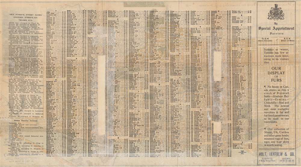
This map was published by W.S. Johnston and Company in Toronto. It was provided compliments of Holt, Renfrew, and Co., furriers to Queen Alexandra and the Prince of Wales (that is, Edward VII), still in operation today as a luxury department store. Though undated, the reference to Queen Alexandra would date it to between 1901 and 1910. A slightly different edition of the map, dated 1903 and attributed to one C. J. Pilkey, is held by the Toronto Public Library as part of the Baldwin Collection of Canadiana. W.S. Johnston and Company also published a at least one edition of a 'Street and street railway guide of Toronto' and a 1911 map of Toronto and its suburbs, both of which are also quite rare. The present edition is only held by the Library and Archives of Canada and is known by us to have been on the market just once in the past fifteen years.Cartographer
W.S. Johnston and Company (fl. c. 1901 – 1930), often as 'W.S. Johnston and Co'y,' was a Toronto–based publisher of books, guides, and maps focusing on Toronto itself. More by this mapmaker...
Condition
Good. Previous repairs to loss at fold intersections with archival tape and tissue paper along folds on verso.
References
OCLC 1007200844.