This item has been sold, but you can get on the Waitlist to be notified if another example becomes available, or purchase a digital scan.
1900 Meekham Map of Raquette Lake, Hamilton County, New York
Township40-meekham-1900$75.00

Title
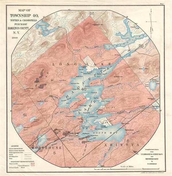
Map of Township 40, Totten and Crossfield Purchase. Hamilton County, N.Y.
1900 (dated) 10.5 x 10 in (26.67 x 25.4 cm) 1 : 31700
1900 (dated) 10.5 x 10 in (26.67 x 25.4 cm) 1 : 31700
Description
This is a 1900 H.S. Meekham map of Raquette Lake in Hamilton County, New York. The map depicts Township 40 from its borders with Townships 39 and 36 to its borders with Townships 5 and 6 and from Township 41 and 5 to Township 35 and Forked Lake. Several locations are labeled around Raquette Lake including Indian Point, Beaver Bay, Antler's Point, Long Point, South Bay, Bluff Point, and North Bay. Camp Pine Knot is depicted on Long Point. The Raquette Lake Railway is illustrated in the lower left quadrant, along with Durant Station and Post Office. Raquette Lake remains a popular summer camp destination to this day. The different colors represent differences in land ownership. The dark pink denotes state lands, while the lighter pink indicates state lands where the timber is reserved. The white areas denote privately owned land.
This map was compiled by H.S. Meekham in 1900 and printed by James B. Lyon.
This map was compiled by H.S. Meekham in 1900 and printed by James B. Lyon.
Condition
Very good. Verso repairs of fold separations. Blank on verso.