This item has been sold, but you can get on the Waitlist to be notified if another example becomes available, or purchase a digital scan.
1911 Russian Alexei Ilyin Map of the Trans-Siberian Railway, Russia
TransSiberianRailway-ilyin-1911$1,300.00


Title
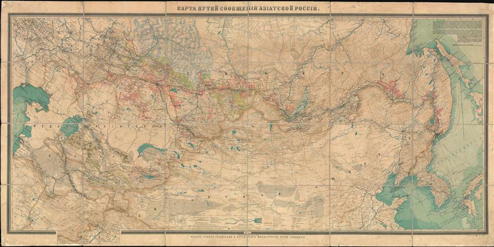
КАРТА ПУТЕЙ СООБЩЕНИЯ АЗІАТСКОЙ РОССIЙ. / Map of Routes of Communication of Asian Russia.
1911 (dated) 35.5 x 71.5 in (90.17 x 181.61 cm) 1 : 4200000
1911 (dated) 35.5 x 71.5 in (90.17 x 181.61 cm) 1 : 4200000
Description
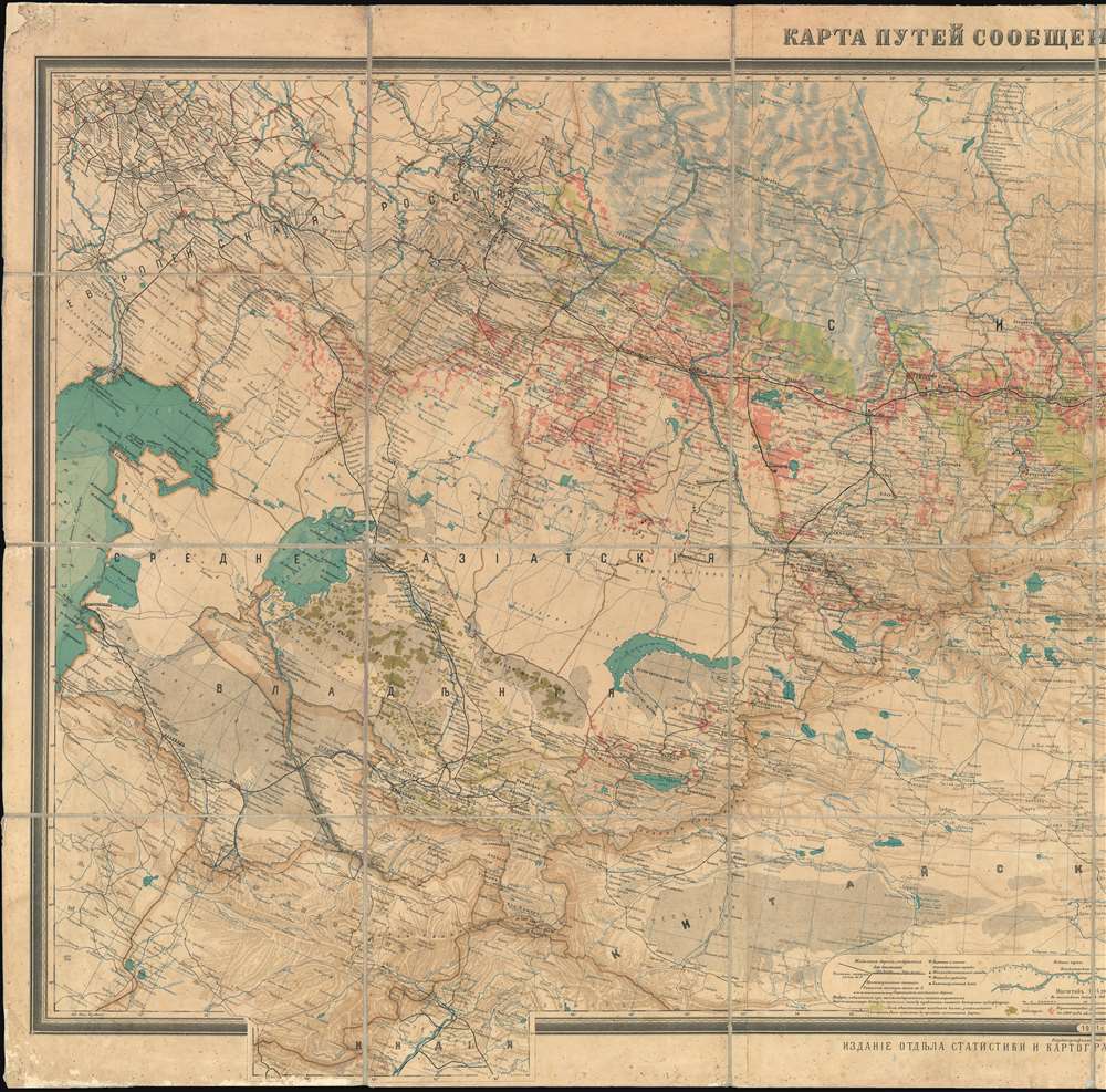
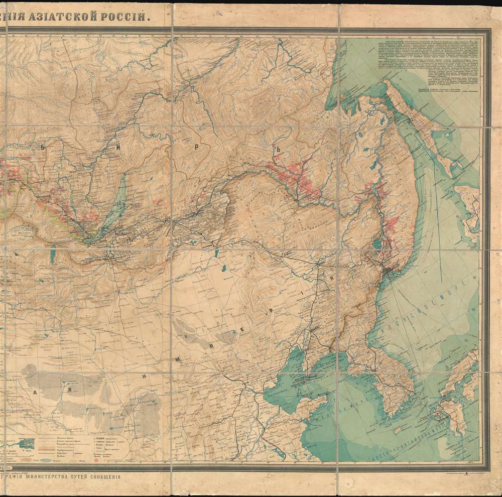
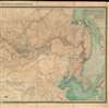
A rare large-scale 1911 Alexei Ilyin map of the Russian Empire in Asia and the Trans-Siberian Railway issued for the Imperial Russian Ministry of Railways. The map catalogs not only the near complexation of the Trans-Siberian Railway, a major development in Russian infrastructure, but also the extensive Siberian resettlement projects instigated under Tsar Nicholas II and Pyotr N. Stolypin. This expansive maps coves from the Caspian Sea to Japan and Korea, and from Yakutsk to northern China. In addition to railroad routes, the map shows communication networks, mines, ironworks, forests, and resettlement areas up to 1910, inclusive.
Trans-Siberian Railway
Russian ambitions to connect Moscow with Vladivostok on the Sea of Japan/Korea began as early as the 1850s. As Russia expanded eastward territorially, its surging population did not follow, leaving vast swaths of fertile land largely empty of major settlement. Riverways and poorly maintained roads unsuitable for wheeled transport provided the only direct connection between Moscow and the frontiers of the empire. The need for a railroad became ever more pressing. Despite decades of rejected plans failed starts, Trans-Siberian Railroad Committee, personally headed by Tsar Nicholas II, saw construction on the Trans-Siberian Railway began in March 1891. Trains began running in 1904, but construction was not finalized until 1916.Stolypin Reforms and Resettlement
The opening of the Trans-Siberian Railroad and coincided with the rise of Pyotr N. Stolypin (1862 -1911). Stolypin served as Minister of Internal Affairs of the Russian Empire and in this role, instituted a series of revolutionary reforms intended to revitalize Russia's feudal agrarian economy and more effectively capitalize on the empire's vast eastern territories. The Stolypin Reforms (1906 - 1914) were intended to transform the traditional obshchina or open-field communal agriculture system into a capitalist property-based system. Russians willing to move to underdeveloped parts of the empire were offered various assistance and concessions. The Stolypin agrarian reforms included numerous resettlement benefits for peasants who moved to Siberia. An Emigration Department was created in 1906. It organized resettlement and assisted settlers during their first years in the new settlements. Settlers received on an average 16.5 hectares of land per man out of total allocation of 21 million hectares. Migrants received a small state subsidy, exemption from taxes, access to low interest credit, and received advice from state-funded agencies specifically developed to help with peasant resettlement.The operation was broadly successful. Between 1890 and 1914 over 10 million people migrated freely from western Russia to areas east of the Urals, generally following the route of the Trans-Siberian Railroad - as can be seen here where red coding illustrates resettlement progress. The reforms were particularly important to Russia's Jewish community, which moved eastward en masse to enjoy greater social, religious, and economic liberty.Chinese Eastern Railway
The most direct route to Vladivostok included traversing Chinese dominated Manchuria. The Qing Dynasty granted Tsarist Russia a railroad concession through Manchuria. Construction began in 1897 and lasted until 1902. The Chinese Eastern Railway was thus critical to Russian plans to reach Port Arthur and Vladivostok, as well as develop Siberia. The Russo-Japanese War (1904 - 1905), wherein Russia was humiliatingly defeated by Imperial Japan, as well as increased instability in China, led Stolypin in 1906 to instigate a new track of the Trans-Siberian Railway along the Amur River fully within Russian borders - as shown on this map.Publication History and Census
This map was published by the Cartographic Institute of Alexei Ilyin for the Imperial Russian Department of Statistics and Cartography of the Ministry of Railways. This was an official publication that was not released commercially and as such, examples are scarce outside of Russian Institutions. We have identified just six examples in the OCLC, at the University of Washington, Yale University, Harvard University, the Library of Congress, and the University of Melbourne. This is the only known example of this map to enter the private market.Cartographer
Alexey Afinogenovich Ilyin (Алексей Афиногенович Ильин; April 11, 1834 - December 4, 1889) was a Russian General Staff officer and map publisher. He was born in Shlisselburg, Leningrad Oblast, Russia. Ilyin founded the publishing firm 'Chromolithography of Poltoratsky, Ilyin, and Co.', with Vladimir Poltoratsky (1830 - 1886) in 1859 in St. Petersburg. Poltoratsky left St. Petersburg and the firm in 1864, and Ilyin changed the firm's name to 'A. Ilyin's Cartographic Establishment'. Ilyin became a lifelong map maker and printer and served as cartographer for the Military Topographic Depot of the General Staff. By the end of his life, Ilyin had risen to the rank of lieutenant-general. Following Ilyin's death, his son Alexey Alexeevich Ilyin (1857 - 1942) took over the business with the help of Ilyin other son, Afinogen Alexeevich Ilyin (1857 - 1904). The company reached its zenith in the 1880s, producing 6 million maps in 1882 alone, which accounted for nearly 90 percent of all civilian maps published in Russia that year. Aside from maps and atlases, A. Ilyin's Cartographic Establishment also published books about geography, Russian Geographical Society publications, and the proceedings of the Geological and Statistical committees and other government agencies. They also published textbooks on mathematics, chemistry, physics, astronomy, and foreign languages, among many other disciplines. A Ilyin's Cartographic Establishment was nationalized following the 1918 Russian Revolution and became the First State Cartographic Enterprise. The factory was transferred to the Ministry of Defense during World War II, known as the Great Patriotic War of 1941 - 1945 in Russia. It was renamed the 444th Military Cartographic Factory in the 1990s. More by this mapmaker...
Condition
Average. Dissected and laid on original linen. Even overall toning. Some edge wear and soling. Corner repairs.
References
OCLC 58471879.