This item has been sold, but you can get on the Waitlist to be notified if another example becomes available, or purchase a digital scan.
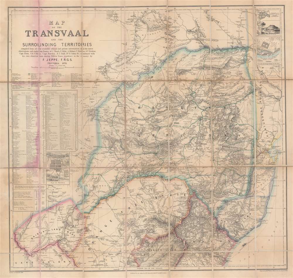
1878 Jeppe Map of the Transvaal (South African Republic) in South Africa
Transvaal-jeppe-1878$150.00

Title
Map of the Transvaal and the Surrounding Territories.
1878 (dated) 23.5 x 25 in (59.69 x 63.5 cm) 1 : 850000
1878 (dated) 23.5 x 25 in (59.69 x 63.5 cm) 1 : 850000
Description
This is a beautiful and scarce 1878 map of the Transvaal or the South African Republic by F. Jeppe. It covers the Boer ruled country in South Africa from modern day Zimbabwe south as far as Durban and depicts the Transvaal, Orange Free State, and Griqualand West, as well as parts of Natal, Zululand, and Basutoland. The map depicts the region in extraordinary detail, noting native tribes, goldfields, mines, roads, towns, farms, bushes, forests, lakes and a host of important topographical features. The routes of various travelers, including Erskine, Sanderson, Hope, Mauch, and several others are noted throughout. A table of postal routes is included near the left margin. A table showing distances and altitudes of projected railway lines appears as well. The upper right quadrant features two insets focusing on the 'Plan of Lourenco Marques (Del. Bay)' and a 'Continuation of Mauch's route to the ruins of Zimbabwe' along with a 'View of the ruins.' Another inset situated in the left lower quadrant contains a 'Plan of Pretoria.'
Historic Context
This map was made two years before the First Boer War, also known as the First Anglo-Boer War. The Transvaal and the Orange Free State had been recognized as independent states by the British since 1852 and 1854 respectively. In 1867, with the discovery of diamonds near the Vaal River, the region became a center of international attention, which would lead the British to annex West Griqualand over Boer protests. In 1877, despite a treaty granting its independence, the British annexed the Transvaal, which led to the First Boer War fought between the British Empire and the independent Boer republics of the Orange Free State and the Transvaal Republic. The war would end with the Pretoria Convention where the Transvaal Republic and the Orange Free State would regain independence.Publication History
This map was compiled from all the available official and private information and the latest observations and exploring routes of C. Mauch, E. Mohr, A. Hubner, T. Baines, S. V. Erskine, Capt. Elton, Col. Colley, Capt. Bawden, R. T. Hall, and Dr. E. Cohen, and combined with his own observations during fifteen years residence in the country, by F. Jeppe, F.R.G.S. in 1878. The map was engraved Edward Weller and published by S. W. Silver and Co.Condition
Very good. Dissected and mounted on linen. Map exhibits red stains along left fold lines, where map is attached to binder. Folds into original cardboard binder.