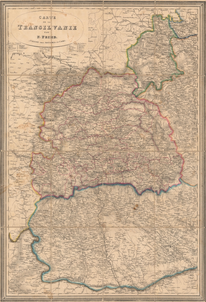
1830 Fried Map of Transylvania, Wallachia, Romania
Transylvania-fried-1830$1,200.00


Title
Carte de la Transilvanie.
1830 (undated) 32.75 x 22.25 in (83.185 x 56.515 cm) 1 : 720000
1830 (undated) 32.75 x 22.25 in (83.185 x 56.515 cm) 1 : 720000
Description
A finely engraved c. 1830 folding map of Wallachia, Transylvania, and surrounding regions, largely correspondent with the present-day country of Romania. It was produced by F. Fried, a Vienna-based cartographer about whom little is known.
In the years just before this map's publication, the region was divided in an uneasy peace, with local rulers under varying degrees of Ottoman and Russian control. This map might have been produced to reflect the outcomes of the Russo-Turkish War of 1828 - 1829, one of which was the destruction of fortifications of the city of Giurgiu (here as Giurgevo), which was transferred to the Russian protectorate of Wallachia.
A Closer Look
This is a highly detailed map with fine engraving and an intricate border. The thirty-odd administrations of Transylvania are noted below the title, divided in Hungarian and German territories (with' Szekler' referring to the Székely people and 'Sachsen' referring to Transylvanian Saxons, who migrated from their namesake homeland over several centuries. Curiously, the map's title is in French, but the rendering of place names is in German.Towards Independence
Like much of southeastern Europe, Transylvania was on the front lines of wars between the Ottoman Empire and various Christian kingdoms in the early modern and modern periods. At the time this map was made, the entire region was undergoing important changes, with Ottoman authority weakening, especially vis-à-vis the Russian Empire, and national identities coalescing.In the years just before this map's publication, the region was divided in an uneasy peace, with local rulers under varying degrees of Ottoman and Russian control. This map might have been produced to reflect the outcomes of the Russo-Turkish War of 1828 - 1829, one of which was the destruction of fortifications of the city of Giurgiu (here as Giurgevo), which was transferred to the Russian protectorate of Wallachia.
Publication History and Census
This map was produced around 1830 by F. Fried and published by Artaria and Co. in Vienna, though little information is available about either. The map is only cataloged among the holdings of the British Library and has no known history on the market.Condition
Good. Dissected and laid on linen. Minor discolorations. Pencil underlining of towns and cities towards bottom.
References
OCLC 557726707.