This item has been sold, but you can get on the Waitlist to be notified if another example becomes available, or purchase a digital scan.
1832 Mitchell's Pocket Map of the United States
TravellersGuide-mitchell-1833$425.00

Title
Mitchell's Travellers Guide Through The United States.
1832 (dated) 17.25 x 21.5 in (43.815 x 54.61 cm)
1832 (dated) 17.25 x 21.5 in (43.815 x 54.61 cm)
Description
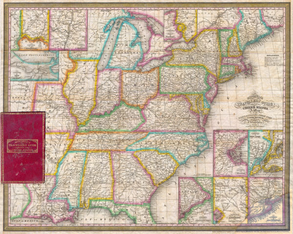
A rare first edition (1832) of Mitchell's ‘Travellers' Guide to the United States. Depicts the eastern half of the United States from Texas (Mexico at the time) and Missouri Territory eastward to the Atlantic. Includes only the northern part of Florida. Labels roadways, major cities, canals, and some geographic features. Made with the traveler in mind. The early part of the 19th century witnessed the westward expansion of European-American toward and eventually beyond the Mississippi. As one of the most popular and inclusive maps of the period, it is no doubt that this map was part of the experience of many westward migrants. In the upper left quadrant three inset mini-maps depicts the Vicinity of New Orleans, the Vicinity of Cincinnati, and the Vicinity of Albany. In the lower right hand quadrant there are five additional inset maps, depicting, the Vicinity of Boston, the Vicinity of New York, The Vicinity of Philadelphia, the Vicinity of Baltimore and Washington and the Vicinity of Charleston. The Great Lake region is shown top center and in excellent detail. Lake Michigan is presented in its distended form. An inset north of Lake Ontario shows the Vicinity of the Falls of Niagara (Niagara Falls). Mitchell first issued this important map and guide in 1832 and issued subsequent revisions and reissues almost yearly until 1849. Accompanied by original red leather binder including a fold out index roughly the same size as the map. Engraved onto a steel plate for printing by Mitchell's associates J.H. Young And D. Haines.
Cartographer
Samuel Augustus Mitchell (March 20, 1792 - December 20, 1868) began his map publishing career in the early 1830s. Mitchell was born in Bristol, Connecticut. He relocated to Philadelphia in 1821. Having worked as a school teacher and a geographical writer, Mitchell was frustrated with the low quality and inaccuracy of school texts of the period. His first maps were an attempt to rectify this problem. In the next 20 years Mitchell would become the most prominent American map publisher of the mid-19th century. Mitchell worked with prominent engravers J. H. Young, H. S. Tanner, and H. N. Burroughs before attaining the full copyright on his maps in 1847. In 1849 Mitchell either partnered with or sold his plates to Thomas, Cowperthwait and Company who continued to publish the Mitchell's Universal Atlas. By about 1856 most of the Mitchell plates and copyrights were acquired by Charles Desilver who continued to publish the maps, many with modified borders and color schemes, until Mitchell's son, Samuel Augustus Mitchell Junior, entered the picture. In 1859, S.A. Mitchell Jr. purchased most of the plates back from Desilver and introduced his own floral motif border. From 1860 on, he published his own editions of the New General Atlas. The younger Mitchell became as prominent as his father, publishing maps and atlases until 1887, when most of the copyrights were again sold and the Mitchell firm closed its doors for the final time. More by this mapmaker...
Condition
Good condition. Detached from original cover (included) and professionally flattened and backed with rice paper. Note restoration in lower right corner. Minor discoloration on original folds. Closed tear repair from left margin. Else clean. Red leather binder included. Binder is in good condition. Within binder is a folding index page on oinon skin paper. Index had some splitting and other damage on original fold lines.
References
Ristow p.304; Buck 284. Rumsey 2088.001. Phillips p. 890. Howes, Wright. 690. Schwartz & Ehrenberg pl.158, p.250 (1835 edition). New York Public Library Map Div. 00-478.