This item has been sold, but you can get on the Waitlist to be notified if another example becomes available, or purchase a digital scan.
1907 Peters Map of Massachusetts, New Hampshire, Rhode Island Trolley Lines
TriStateTrolley-peters-1907$175.00

Title
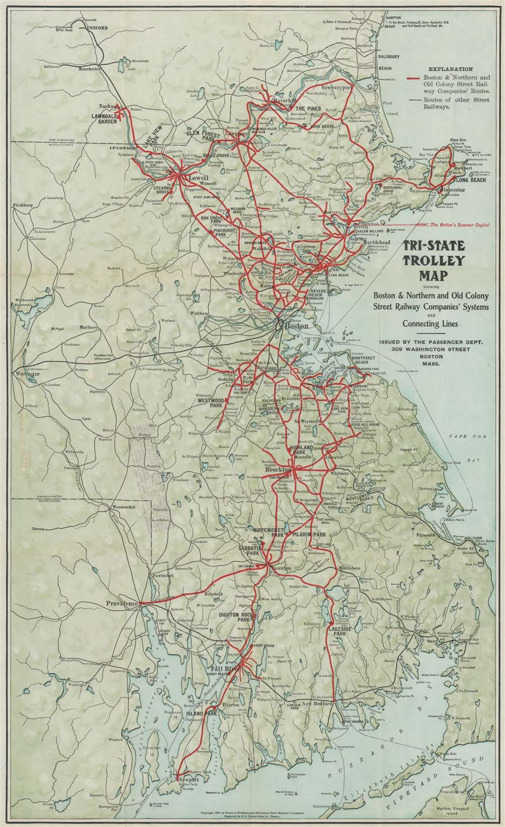
Tri-State Trolley Map Showing Boston and Northern and Old Colony Street Railway Companies' Systems and Connecting Lines.
1907 (dated) 23.75 x 14.5 in (60.325 x 36.83 cm)
1907 (dated) 23.75 x 14.5 in (60.325 x 36.83 cm)
Description
This is a 1907 C.J. Peters and Son map of Massachusetts, New Hampshire, and Rhode Island trolley lines. Thick red lines trace the Boston and Northern and Old Colony Street Railway Companies' routes throughout the region from Newburyport, Massachusetts south to Newport, Rhode Island. Thin black lines follow other street railway routes, allowing viewers a more general understanding of the street railway network in this part of the United States around the turn of the 20th century. Cities and towns along these routes are labeled. Among the cities served by these two railways are Boston, Providence, Newport, Salem, Marblehead, and Nashua. Lakers and rivers are illustrated and shading is used to subtly include the region's topography.
The Boston and Northern Street Railway Company
The Boston and Northern Street Railway Company operated horse-drawn and electric streetcar railroads in Boston, Massachusetts, and in communities north of the city. It was founded as the Lynn and Boston Railroad on April 6,1859, and, through a series of acquisitions and mergers, grew into the largest mass transit provider in northeastern Massachusetts. The Boston and Northern became the Bay State Street Railway on August 8, 1911. The Eastern Massachusetts Street Railway Company purchased the Bay State Street Railway Company on January 15, 1919. The Eastern Massachusetts Street Railway Company was finally acquired by the MBTA in 1968.The Old Colony Street Railway Company
The Old Colony Street Railway Company was founded in 1881 as the Brockton Street Railway Company. It operated a horse-drawn and electric streetcar railway in Boston and further south. The company's name changed on February 7, 1901 to the Old Colony Street Railway. The Boston and Northern Street Railway bought the Old Colony Street Railway on July 1, 1911.Publication History and Census
This map was engraved by the C.J. Peters and Son Company of Boston, Massachusetts, and published by the Boston and Northern and Old Colony Street Railway Companies in 1907. Two examples are cataloged in OCLC as part of the collections at Harvard University and the Wisconsin Historical Society.Cartographer
C.J. Peters and Son Company (fl. c. 1855 - 1920) was an an American typography, electrotyping, engraving, printing, and stereotyping firm active in Boston during the 19th and 20th centuries. The firm produced a wide range of products. More by this mapmaker...
Condition
Very good. Exhibits light wear along original fold lines. Verso repair to a fold separation. In stamp from Trolley Information Bureau on verso.
References
OCLC 891751147.