This item has been sold, but you can get on the Waitlist to be notified if another example becomes available, or purchase a digital scan.
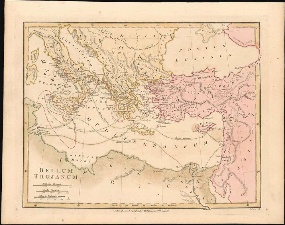
1798 Wilkinson Map of the Eastern Mediterranean w/ tracks of Greek Heroes
TrojanWar-wilkinson-1798$75.00

Title
Bellum Trojanum
1796 (dated 1798) 8.75 x 11.25 in (22.225 x 28.575 cm) 1 : 10036636
1796 (dated 1798) 8.75 x 11.25 in (22.225 x 28.575 cm) 1 : 10036636
Description
This is a fine 1798 map of the Eastern Mediterranean by Robert Wilkinson, focusing on the region encompassing the events of Homer’s Odyssey and Virgil’sAeneid, and showing the travels of its principal characters. Wilkinson's map covers from Carthage to Syria, reaching as far north as the Black Sea; in the south, the Nile River extends beyond the border of the map. Italy and the Greek Islands are, of course, shown in detail. Although the place names are the ancient ones relevant to the events described in the epic poems, the topography of the map is modern.
Publication History and Census
The map, though dated September 7th, 1798, appeared both in the 1796 and the 1808 editions of Wilkinson’s Atlas Classica before its publishing date was altered to 1815. While we see three separate examples of this map in institutional collections, 18 examples of the 1796 edition of the book can be found, and many of the later editions as well.Cartographer
Robert Wilkinson (fl. c. 1758 - 1825) was a London based map and atlas publisher active in the late 18th and early 19th centuries. Most of Wilkinson's maps were derived from the earlier work of John Bowles, one of the preeminent English map publishers of the 18th century. Wilkinson's acquired the Bowles map plate library following that cartographer's death in 1779. Wilkinson updated and retooled the Bowles plates over several years until, in 1794, he issued his first fully original atlas, The General Atlas of the World. This popular atlas was profitably reissued in numerous editions until about 1825 when Wilkinson died. In the course of his nearly 45 years in the map and print trade, Wilkinson issued also published numerous independently issued large format wall, case, and folding maps. Wilkinson's core cartographic corpus includes Bowen and Kitchin's Large English Atlas (1785), Speer's West Indies (1796), Atlas Classica (1797), and the General Atlas of the World (1794, 1802, and 1809), as well as independent issue maps of New Holland (1820), and North America ( 1823). Wilkinson's offices were based at no. 58 Cornhill, London form 1792 to 1816, following which he relocated to 125 Frenchurch Street, also in London, where he remained until 1823. Following his 1825 death, Wilkinson's business and map plates were acquired by William Darton, an innovative map publisher who reissued the General Atlas with his own imprint well into the 19th century. More by this mapmaker...
Source
Wilkinson, R . Atlas classica being a collection of maps of the countries mentioned by the ancient authors, both sacred and profane
Condition
Very good. Light toning. Contemporary wash color.
References
OCLC :859203323.