This item has been sold, but you can get on the Waitlist to be notified if another example becomes available, or purchase a digital scan.
1937 Imprimerie Gaillac-Monrocq. Pictorial Map of Tunisia
TunisieTouristique-gaillac-1937$62.50

Title
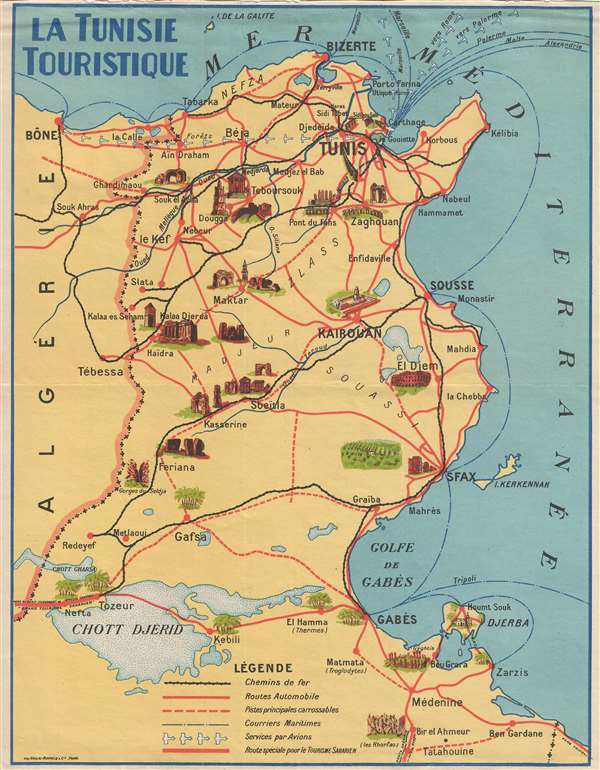
La Tunisie Touristique.
1937 (undated) 10.5 x 8.25 in (26.67 x 20.955 cm) 1 : 2000000
1937 (undated) 10.5 x 8.25 in (26.67 x 20.955 cm) 1 : 2000000
Description
This is a c. 1937 Imprimerie Gaillac-Monrocq. pictorial map of Tunisia. The map depicts the region from the Mediterranean Sea to the Chott el-Jérid (Chott Djerid) and from Algeria to the Mediterranean Sea. Numerous cities and towns are labeled, including Tunis, Kairouan, Sousse, Sfax, and Gabes. As this piece is geared toward tourists, several sites that would appeal to tourists are illustrated in profile, such as Roman ruins at El Djem and Dougga, the Great Mosque at Kairouan, and the Selja Gorges, along with others. A key at the bottom of the map explains the various notations used for noting railway lines, roads, tracks that are suitable for cars, shipping lanes, and air routes.
This map was created by Imprimerie Gaillac-Monrocq. and printed c. 1937.
This map was created by Imprimerie Gaillac-Monrocq. and printed c. 1937.
Condition
Very good. Wear along top margin. All text French.