This item has been sold, but you can get on the Waitlist to be notified if another example becomes available, or purchase a digital scan.
1871 Sikkel Manuscript Map of Greece and the Balkans
Turkeie-sikkel-1871$100.00

Title
Turkeie and Griekenland.
1871 (undated) 8.5 x 9.5 in (21.59 x 24.13 cm)
1871 (undated) 8.5 x 9.5 in (21.59 x 24.13 cm)
Description
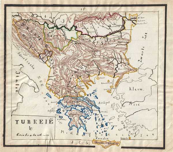
This is a lovely 1871 manuscript map of Greece, the Balkans and the European part of Turkey by J. C. Sikkel. Entirely hand-drawn with beautifully rendered topography, the map covers from Romania to Candia or Crete. The modern day states of Greece, Albania, Bosnia, Macedonia, Montenegro, Serbia, Bulgaria and Romania are included. Throughout, major towns, cities, rivers, mountains, etc. are noted.
The map depicts the waning years of Ottoman hegemony in the region, with the Greek nationalist movement attaining independence for the Peloponnese in 1821. The Ionian Republic, under the protection of Great Britain, was also free of Ottoman control. The other Grecian and Balkan states, including Serbia, Croatia, Moldavia, Wallachia, Albania, and Macedonia, remained at least nominally under Ottoman control until 1878.
The map depicts the waning years of Ottoman hegemony in the region, with the Greek nationalist movement attaining independence for the Peloponnese in 1821. The Ionian Republic, under the protection of Great Britain, was also free of Ottoman control. The other Grecian and Balkan states, including Serbia, Croatia, Moldavia, Wallachia, Albania, and Macedonia, remained at least nominally under Ottoman control until 1878.
Condition
Very good. Minor spotting. Some edge wear and toning. Creases along margin. Map proper pasted on separate sheet of paper. Left border ripped.