This item has been sold, but you can get on the Waitlist to be notified if another example becomes available, or purchase a digital scan.
1700 Martineau Map of Arabia, Turkey, Persia and Greece
TurquieAsie-martineau-1700$125.00

Title
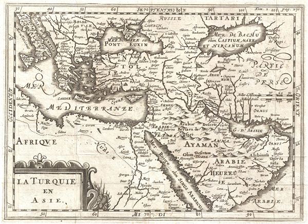
La Turquie en Asie.
1700 (undated) 8 x 10.5 in (20.32 x 26.67 cm)
1700 (undated) 8 x 10.5 in (20.32 x 26.67 cm)
Description
An uncommon c. 1700 map of the Middle east issued for Maretineau du Plessis. The map covers from Italy to the Caspian Sea and from the Arabian Sea to Russia, inclusive of Arabia, egypt, Persia, Greece, Italy, and Turkey. A decorative title cartouche sits in the lower left quadrant. Cartographically this map is most notable for its misorientation of the Caspian Sea, an error common to maps of the 16th and 17th though rarely the 18th century. This singular element allows us to date is original composition to the late 16th or early 17th century. Regardless of its original composition date, this map was prepared for Martineau du Plessis' Nouvelle Geographie, published in 1700.
Cartographer
Martineau Du Plessis (fl. c. 1700) was a French geographer and schoolmaster from Fontenay, possibly Fontenay-le-Comte. He is best known for his multivolume geography, Nouvelle Geographie issued in 1700. Little else is known of his life. More by this mapmaker...
Source
Martineau du Plessis, Nouvelle Geographie, ou Description Exacte de l'Univers (George Gallet, Directeur de l'Imprimerie des Huguetan), vol 2, 1700.
Condition
Very good. Original fold lines. Blank on Verso.
References
Bibliotheque Nationale de France: Réserve A 200 189