
This item below is out of stock, but another example (left) is available. To view the available item, click "Details."
Details
1844 Black Map of the United States
1844 (undated) $200.00
1840 Black map of the United States
UnitedStates-black-1840$100.00

Title
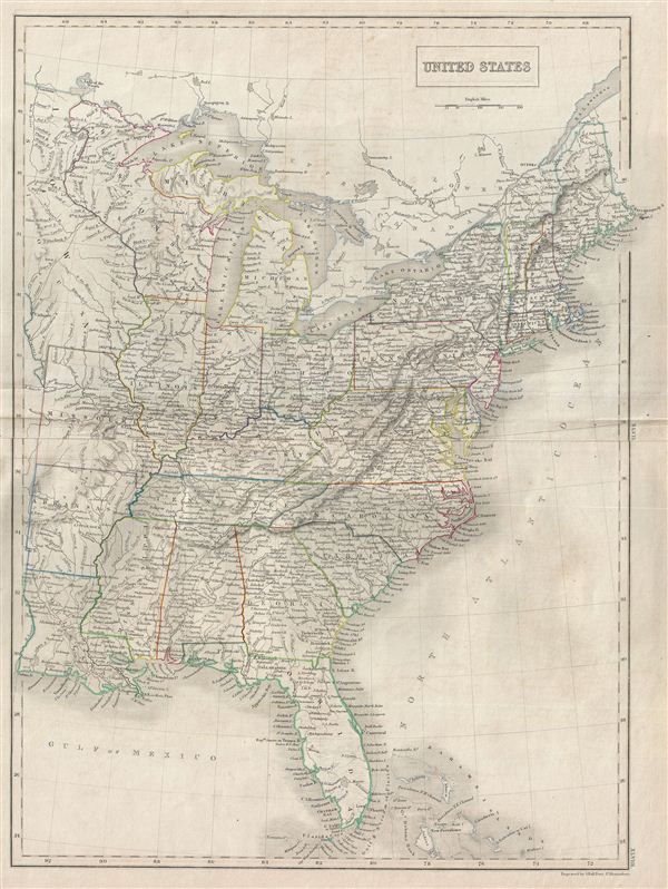
United States.
1840 (undated) 21 x 16 in (53.34 x 40.64 cm)
1840 (undated) 21 x 16 in (53.34 x 40.64 cm)
Description
A fine example of Adam and Charles Black's 1840 map of the United States. Covers the populous eastern portions of the United States from Lake Superior in the north to the Bahamas in the south and from Missouri in the west to Maine in the east. The United States at this time was witnessing a period of rapid expansion as well as rising anxiety over the issue of slavery. These tensions would grow over the next twenty years culminating in the American Civil War. This map was engraved by S. Hall for issue in the 1840 edition of Black's General Atlas.
Cartographer
Charles and Adam Black (fl. 1807 - present) were map and book publishers based in Edinburgh. Charles and his uncle, Adam, both of Edinburgh, Scotland, founded their publishing firm in 1807. They published a series of maps and atlases throughout the 19th century. In addition to an array of atlases, the Black firm is known for their editions of the Encyclopedia Britannica (1817 - 1826) and the first publishing of Sir Walter Scott's novels in 1854. In 1889 the A. & C. Black publishing house moved to London where it remains in operation to this day. More by this mapmaker...
Source
Hall, Sydney, Black's General Atlas: A series of Fifty-Four Maps from the Latest and Most Authentic Sources, Engraved on Steel, In the First Style of the Art, (Edinburgh: Adam and Charles Black) 1840.
Condition
Very good. Blank on verso. Original platemark visible. Original centerfold.
References
Rumsey 2305.055 (1854 edition). Philips (atlases) 4334.