This item has been sold, but you can get on the Waitlist to be notified if another example becomes available, or purchase a digital scan.
1838 Bradford Map of the United States, Large Iowa, Indian, and Oregon Territories
UnitedStates-bradford-1838$475.00

Title
United States.
1838 (dated) 23 x 14 in (58.42 x 35.56 cm) 1 : 8236800
1838 (dated) 23 x 14 in (58.42 x 35.56 cm) 1 : 8236800
Description
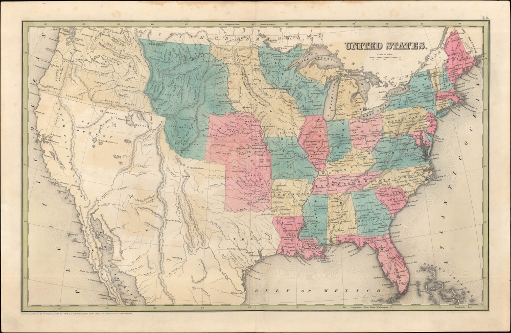
This is Thomas Bradford's 1838 map of the United States of America, from the first edition of his Universal Illustrated Atlas. It is notable for reflecting contemporary territorial disputes, the evolving territorial configuration of the country, and the development of geographical knowledge of the western half of North America.
A Closer Look
Displaying the portion of North America corresponding with today's contiguous United States, this map uses color shading to distinguish states and territories. Cities, rivers, mountains, forts, and other features are labelled throughout, as are the names of dozens of Native American groups. Texas, by this time an independent republic, is noted, though Bradford does not make a statement here on the hotly disputed border between the new country and Mexico (though his Texas map from the same atlas does). The geography west of the Missouri River is relatively cursory and tentative. Cartographic myths such as a 'Great Desert' in today's Colorado are included, though Bradford has dispensed with the apocryphal Buenaventura River, common on maps of the era. Great Salt Lakes is identified as Lake Timpanogos.Territorial Evolution
The territorial configuration of the U.S. captured here only existed for a short time in the late 1830s and early 1840s, between the creation of the Wisconsin and Iowa Territories and the admission of Texas into the union. The Iowa Territory here extends northwards to the 49th parallel north, the current border between the U.S. and Canada, covering parts of Minnesota and the Dakotas. Likewise, the Wisconsin Territory includes most of the later state of that name as well as portions of future Minnesota, and the Indian Territory, later reduced to today's Oklahoma, takes in the later territory of Kansas. To the west is a large unincorporated territory, sometimes as districts named after regions or larger Native American groups (Mandan, Sioux, Osage, Ozark) on slightly earlier maps, roughly corresponding to the later states of Colorado, Wyoming, and Montana, as well as the western portion of the Dakotas.Territorial Disputes
A territorial dispute between the United States and Great Britain in the northern part of the Wisconsin Territory (now the Arrowhead Region of Minnesota) is referenced. Not mentioned is a similar disagreement over the northern border of Maine, which resulted in the 'Aroostook War' (hardly deserving of the name) in 1838-1839. Both disputes resulted from earlier poor understanding of geography and resulting ambiguities in the 1783 Treaty of Paris, and both were resolved by the 1842 Webster-Ashburton Treaty, leaving the Oregon Territory as the only major remaining territorial disagreement between the U.S. and Great Britain.54-40 or Fight!
Here the Pacific Northwest border of the United States is not depicted at the 49th parallel, but continues beyond the scope of the map, to the parallel 54-40' north. The Oregon Question was disputed for decades between the United States and Great Britain, and the basis for the dispute was mostly economic. The fur trade in the Pacific Northwest was booming, which meant that both British and American companies and citizens wanted access to this area. American interest was also rooted in the concept of Manifest Destiny and westward expansion. Although the border was set at the 49th parallel by 1846, the crisis was not fully resolved until 1872.Publication History and Census
This map was prepared by Thomas Bradford for publication in the first edition of his Universal Illustrated Atlas. It is dated 1838 but the atlas was not published until 1841, which likely explains the inclusion of the Iowa Territory (established in July 1838). The map and Bradford's atlas are well-represented in institutional collections but, as one of the most desirable maps from Bradford's Universal Illustrated Atlas, the map is somewhat scarce to the market, especially in this state.Cartographer
Thomas Gamaliel Bradford (1802 - 1887) was born in Boston, Massachusetts, where he worked as an assistant editor for the Encyclopedia Americana. Bradford's first major cartographic work was his revision and subsequent republishing of an important French geography by Adrian Balbi, Abrege de Geographie published in America as Atlas Designed to Illustrate the Abridgment of Universal Geography, Modern and Ancient. Afterwards Bradford revised and expanded this work into his own important contributions to American cartography, the 1838 An Illustrated Atlas Geographical, Statistical and Historical of the United States and Adjacent Countries. Bradford's cartographic work is significant as among the first to record Texas as an independent nation. In his long career as a map publisher Bradford worked with William Davis Ticknor of Boston, Freeman Hunt of New York, Charles De Silver of Philadelphia, John Hinton, George Washington Boynton, and others. We have been able to discover little of Bradford's personal life. More by this mapmaker...
Source
Bradford, T. G. and Goodrich, S. G., A Universal Illustrated Atlas, exhibiting a Geographical, Statistical, and Historical view of the World, (Boston: Charles D. Strong) 1841.
The Universal Illustrated Atlas is one of the great American atlases of the first half of the 19th century. The atlas was first published in 1838 under the imprint of Charles D. Strong. It replaced and superseded Bradford's earlier smaller format Illustrated Atlas, Geographical, Statistical, and Historical, of the United States and the Adjacent Countries. Numerous reissues of the Universal Illustrated Atlas followed until about 1848. Although there are minor variations between the editions, most contain about 50 maps, the majority of which focus on the United States. Bradford's atlases are significant for recording North America during the Republic of Texas Era. In later editions, particularly the 1846 edition, Bradford illustrates the boom in railroad construction, possibly with the idea that his maps would aid travelers in planning journeys by rail. It was compiled by Thomas Gamaliel Bradford and Samuel Griswold Goodrich with most of the plates engraved by George Washington Boynton (fl. c. 1830 - 1850). Other contributors include Thomas Gordon (1778 - 1848), Fielding Lucas Jr. (1781 - 1854), Samuel Edward Stiles (1844 - 1901), Sherman and Smith (fl. c. 1829 - 1855), and Horace Thayer (1811 - c. 1874).
Condition
Very good. Slight water damage on top edge. Slight wear on original folds. Newly colored.
References
Rumsey 0089.005. OCLC 33964464.