This item has been sold, but you can get on the Waitlist to be notified if another example becomes available, or purchase a digital scan.
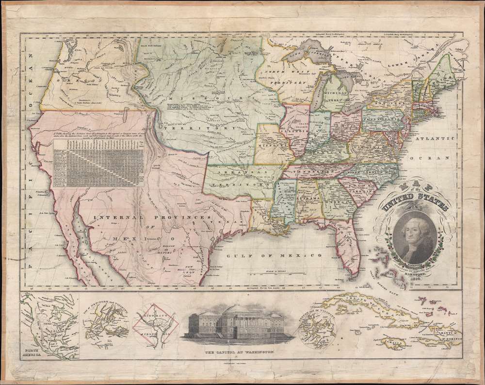
1828 Ensign Map of the United States - Manifest Destiny!
UnitedStates-ensign-1828$1,800.00

Title
Map of the United States Compiled from the most Authentic Sources.
1828 (dated) 22.5 x 28.5 in (57.15 x 72.39 cm) 1 : 7000000
1828 (dated) 22.5 x 28.5 in (57.15 x 72.39 cm) 1 : 7000000
Description
This is Timothy Ensign's 1829 map of the United States - one of the earliest to illustrate the United States stretching to the Pacific. Generally known as the 'Washington Map' for the portrait of George Washington in the lower right, Ensign's map covers the United States from Oregon to the Atlantic and from Canada to Mexico. As this map predates the Texas Revolution, the Mexican American War, and the 1846 Treaty of Guadeloupe-Hidalgo, all of the southwest, including California, Arizona, New Mexico, Nevada, Utah, and Texas are part of Mexico.
Manifest Destiny
Manifest Destiny was an expansionist doctrine that developed in the United States in the early 19th century. Rooted in religious/moral zealotry, American exceptionalism, romantic nationalism, greed, and notions of racial supremacy, Manifest Destiny argued that the United States should expand its cultural and political influence across the continent. The march of Manifest Destiny can trace its beginning to the Louisiana Purchase (1803) and Lewis and Clark Expedition (1803 - 1806). By the early 1910s, it began appearing in maps, the most notable being the 1816 John Melish map - and its subsequent editions. The present map follows in this lineage - expressing not just the reality, but the ambition of the United States.Period Advertisement
An advertisement for this map appeared in the April, 1829 Baltimore Patriot,We have examined a …. Map of the United States, published by Mr. Timothy Ensign, of Hartford, Conn. And are well pleased with the plan and execution. It is projected on a scale of 100 miles to an inch; and it is said to be accurately delineated, with all the late improvement. In one respect it is superior to the large maps of Finlay and lay, as it extends west to the Pacific Ocean. It is ornamented with a handsomely finished likeness of General Washington, and a view of the Capitol. It contains a table of distances between all the capital Towns. The expense, which is only Four Dollars, is so moderate, that most persons who are desirous to possess a map of our country, will, we presume, avail themselves of the present opportunity.
'Famous' Missouri Territory Legend
There is an interesting note in Missouri Territory near the Upper Platte River that Rumsey notes is 'famous' and Wheat also quotes it, but we have found no references to it otherwise:Missouri Territory is a vast wilderness consisting chiefly of immense plains, almost destitute of wood, except in the neighborhood of streams. It is traversed by numerous herds of Buffalo and wild Horses, and by a few roving tribes of Indians.
Publication History and Census
This map was first published in 1826 by Asaph Willard and Eleazer Huntington. Subsequently the plate seems to have moved around among publishers in Hartford. They first passed to Timothy Ensign, as here, in 1828. Then to Willis Thrall in 1829. Thrall released edition in 1831 and 1833. Wheat notes an 1832 Phelps edition, although he states that it was 'modified.' Despite multiple issues over multiple years, the map is scarce in all states and editions. Wheat does not note an 1828, Ensign, nor is there one in Rumsey's collection, so this particular edition seems exceptionally scarce.Cartographer
Timothy Ensign (September 29, 1795 - September 16, 1849) was a map publisher based in Hartford, Connecticut, active in the early to mid-19th century. Early in his career, Timothy Ensign worked closely with the Hartford both D. W. Kellogg (1836 - 1841) and E. B. and E. C. Kellogg (1842 - 1848). From 1835, he also partnered with his son, Edward Hooker Ensign (1818 - 1871), and Horace Thayer (1811 - 1875) under the imprint of 'Ensigns and Thayer', until his untimely death in 1849 - after which the firm was renamed in the singular, 'Ensign and Thayer'. More by this mapmaker...
Condition
Good. Full professional restoration. Minor infill. Clean verso linen. A few edge cracks - stabilized.
References
cf. Wheat, C. I., Mapping of the Transmississippi West, 1540 – 1861, #397, 400, 407.