1957 Forces Belges en Allemagne Pictorial Map of the United States
UnitedStates-fba-1957$750.00

Title
The United States of America.
1957 (undated) 19.5 x 23 in (49.53 x 58.42 cm)
1957 (undated) 19.5 x 23 in (49.53 x 58.42 cm)
Description
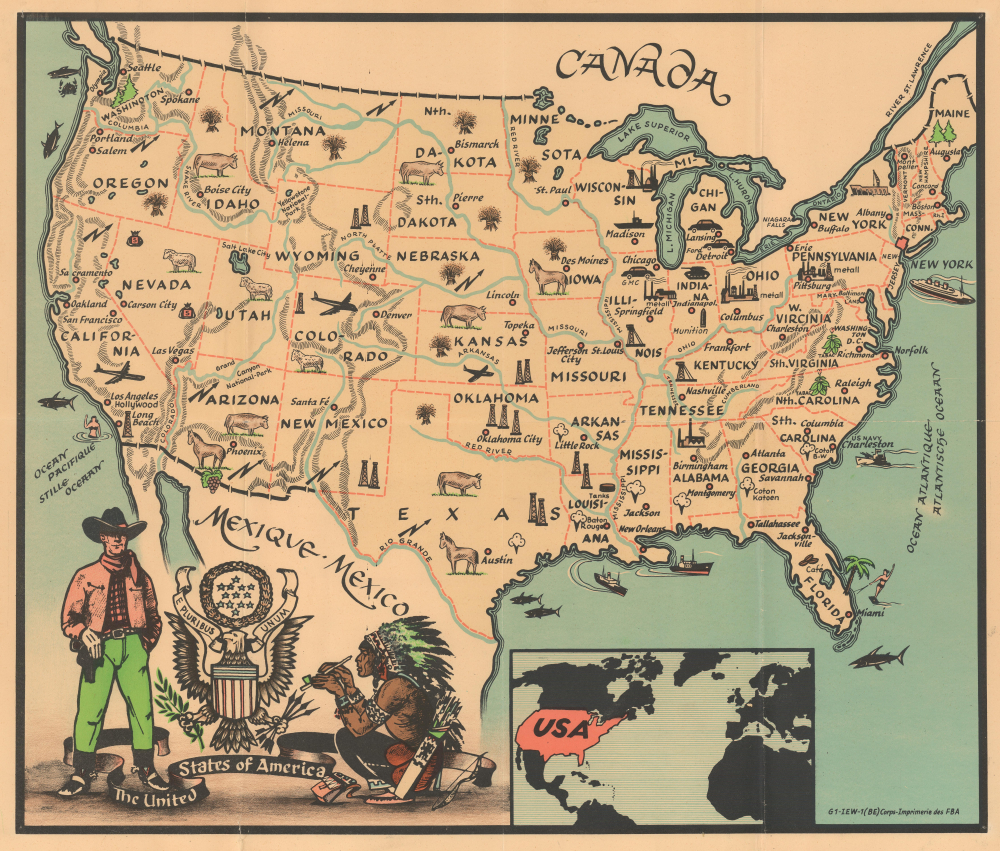
This is an extremely rare c. 1957 pictorial map of the United States published by the Forces belges en Allemagne (FBA) (Belgian Forces in Germany). This map was published by the Belgian army in Germany for the children of Belgian soldiers stationed there (see below).
By 1950, over 40,000 Belgian soldiers were in the Belgian Sector. The soldier's families also lived in the sector, which meant that the Belgian Army needed to take care of them, including the children. This led to the creation of a system of schools operated by the FBA. The first schools opened in 1946, and classes were conducted in both Dutch and French. The Dutch and French sections separated during the 1965-1966 school year. Over 21,000 students were enrolled in FBA schools in 1969. The last school closed when Camp Vogelsang, located on the German border, shut down in December 2005.
A Closer Look
The map depicts the continental United States and labels every state and its capital. The Great Lakes and the major rivers are illustrated and identified. The mountain ranges are illustrated but not labeled. Small pictorial icons appear in every state, highlighting at least one of their major products. Among these are cattle, sheep, horses, oil, and silver. Cotton is emphasized in the Deep South, and tobacco appears in both Virginia and North Carolina. Cars are illustrated in Michigan and Illinois, and tanks and munitions are emphasized in Indiana. The aviation industry is illustrated in Kansas, Colorado, and California. A small inset map along the bottom border situates the U.S.A. in relation to Belgium, the only other country not shaded black.Les Forces belges en Allemagne (FBA)
Beginning in 1955, the Belgian occupation forces in post-World War II Germany were known as the Forces belges en Allemagne (FBA). After World War II, Germany was divided into Occupation Zones, with the Americans, British, French, and Soviets each occupying part of defeated Germany to police and help rebuild. After Belgium had recovered somewhat, the Belgian government sent three brigades to the British Occupation Zone that arrived on April 1, 1946. These soldiers were under British command at that time. On October 15, 1946, the British created the Belgian Occupation Zone out of the British Occupation Zone. Not long after, with the onset of the Cold War, the mission of the Belgian occupation forces (and those of the other Allied powers) shifted from occupation to protection, and it was officially changed to the Defense of West Germany in 1955. The Belgian First Infantry Brigade was the unit that operated in Germany and remained there until 2005.By 1950, over 40,000 Belgian soldiers were in the Belgian Sector. The soldier's families also lived in the sector, which meant that the Belgian Army needed to take care of them, including the children. This led to the creation of a system of schools operated by the FBA. The first schools opened in 1946, and classes were conducted in both Dutch and French. The Dutch and French sections separated during the 1965-1966 school year. Over 21,000 students were enrolled in FBA schools in 1969. The last school closed when Camp Vogelsang, located on the German border, shut down in December 2005.
Publication History and Census
This map was published by the Forces belges en Allemagne c. 1957. The printing information in the lower right corner states that it was printed by the FBA, the 1st Belgian Corps. This is the only known cataloged example of this map and is, in fact, the only known example of a map published by the FBA.Condition
Good. Wear along original fold lines. Verso repairs to fold separations. Closed margin tears professionally repaired on verso.