This item has been sold, but you can get on the Waitlist to be notified if another example becomes available, or purchase a digital scan.
1949 Hyde de Grange Pictorial Map of the United States
UnitedStates-hydedegrange-1949$125.00

Title
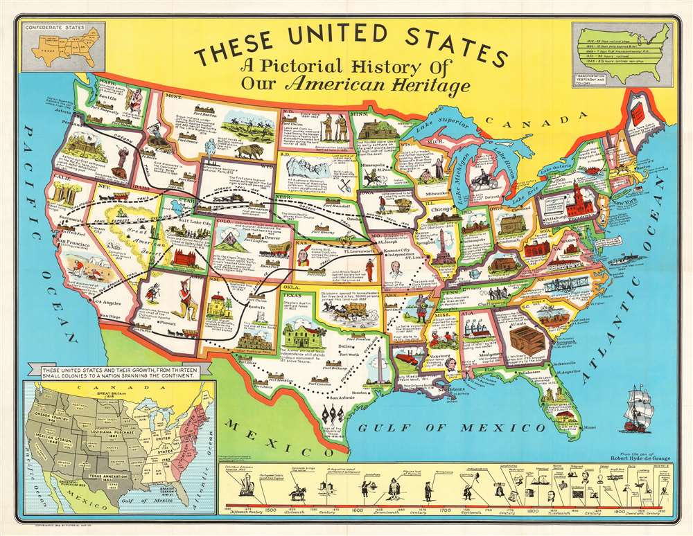
These United States A Pictorial History of Our American Heritage.
1949 (dated) 27.5 x 35.75 in (69.85 x 90.805 cm) 1 : 5700000
1949 (dated) 27.5 x 35.75 in (69.85 x 90.805 cm) 1 : 5700000
Description
This is a 1949 Robert Hyde de Grange pictorial map of the United States. The map features illustrations of famous buildings, sites, historical events, and people, and presents an intriguing window into post-war America. Events chronicle American history from the 16th century, such as Ponce de Leon's discovery of Florida, through westward expansion and the Civil War to the early 20th century. Covered wagons, frontier forts, and gold miners complete the frontier aesthetic. The Mormon Trail, Oregon Trail, California Trail, and the legendary Pony Express all contribute too. Sites, including Mount Rushmore, Old Faithful, Fort Sumter, and Independence Hall, provide an even more comprehensive visual summary. A timeline along the bottom border identifies some critical events in the history of Europeans in North America, from Columbus's discovery in 1492 to the launching of the United Nations and the Atomic Age. An inset in the lower-left corner provides a more concrete summary of America's westward expansion, identifying the many purchases and expansions, along with the year each state joined the union.
Publication History and Census
This map was created by Robert Hyde de Grange and published by the Pictorial Map Company in 1949. Three examples are cataloged in OCLC and are part of the institutional collections at the Library of Virginia, the Buffalo and Erie County Public Library, and Southern Illinois University.Condition
Very good. Minor wear along original fold lines.
References
Rumsey 9920.000. OCLC 36980267.