This item has been sold, but you can get on the Waitlist to be notified if another example becomes available, or purchase a digital scan.
1868 Land Office Map of the United States w/ Gold Deposits
UnitedStates-landoffice-1868$500.00

Title
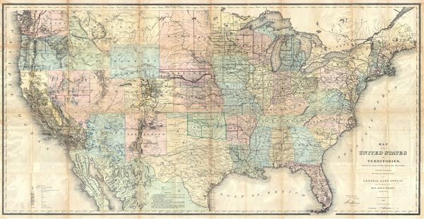
Map of the United States and Territories, Showing the extent of Public Surveys and other details, constructed from the Plats and official sources of the General Land Offices, Under the direction of Hon. Jos. S. Wilson, Commissioner by Joseph Gorlinsi, Draughtsman, 1868.
1868 (dated) 30 x 56 in (76.2 x 142.24 cm)
1868 (dated) 30 x 56 in (76.2 x 142.24 cm)
Description
This is an extremely interesting 1868 U.S. Land Office map of the United States. Covering the entire country on a rectangular projection, this map is intended to illustrate the extant of the Land Survey as it worked its way westward. In this map the surveyed areas are subdivide by tiny squares, those marked with an + are near the outer limits of the survey, while those marked with an o are not yet subdivided. This map also illustrates mineral deposits throughout the country with the rich gold and silver deposits in California, Colorado, Arizona, Nevada, and Montana clearly noted. The map also notes some topographical features, American Indian territories, the locations of fortifications and land offices, major and minor cities, transcontinental and local railway lines, and the routes taken by notable military expeditions and explorers. This map was prepared and accompanies the Report of the Commissioner of General Land Office for the Year 1868.
CartographerS
The General Land Office (1812 - 1946) was an independent agency charged with the administration and sale of public lands of the western territories of the United States under the Preemption Act of 1841 and the Homestead Act of 1862. During a time of frenetic energy and rapid westward expansion, the Land Office oversaw the surveying, platting, mapping and eventually the sale of much of the Western United States and Florida. The structural layout of the western United States that we see today, and many of their district and county divisions, are direct result of the early surveying work of the General Land Office. More importantly, as a branch of the Federal Government in Washington D.C. and the only agency able to legally sell and administer public lands in the western territories of the United States, the General Land Office played a pivotal role in consolidating power away from the original states and into the hands of the centralized federal government. The General Land Office was absorbed into the Department of Interior in 1849 and in 1946 merged with the United States Grazing Service to become the Bureau of Land Management. Today the Bureau of Land Management administers the roughly 246 million acres of public land remaining under federal ownership. More by this mapmaker...
Julius (Julien) Bien (September 27, 1826 - December 21, 1909) was a German-Jewish lithographer and engraver based in New York City. Bien was born in Naumburg, Germany. He was educated at the Academy of Fine Arts, Cassell and at Städel's Institute, Frankfurt-am-Main. Following the suppression of the anti-autocratic German Revolutions of 1848, Bien, who participated in the pan-German movement, found himself out of favor in his home country and joined the mass German immigration to the United States. Bien can be found in New York as early as 1849. He established the New York Lithographing, Engraving & Printing Company in New York that focused on the emergent chromo-lithograph process - a method of printing color using lithographic plates. His work drew the attention of the U.S. Government Printing Office which contracted him to produce countless government maps and surveys, including the Pacific Railroad Surveys, the census, numerous coast surveys, and various maps relating to the American Civil War. Bien also issued several atlases both privately and in conjunction with a relation, Joseph Bien. At the height of his career Bien was elected president of the American Lithographers Association. After his death in 1909, Bien's firm was taken over by his son who promptly ran it into insolvency. The firm was sold to Sheldon Franklin, who, as part of the deal, retained the right to publish under the Julius Bien imprint. In addition to his work as a printer, Bien was active in the New York German Jewish community. He was director of the New York Hebrew Technical Institute, the New York Hebrew Orphan Asylum, and president of the B'nai B'rith Order. Learn More...
Source
Wilson, J., Report of the Commissioner of General Land office for the Year 1868, (Washington, Government Printing Office) 1868.
Condition
Good. This map, like all Land Office Report maps is printed on very thin paper and was folded into the back of the accompanying book. Most examples suffer from extreme condition issues due to the size and print quality of the map. This one is better than most, exhibiting average brittleness and only minor loss at fold intersections and discoloration along original fold lines. Like most examples, splitting along the fold lines has become an issue and in many cases archival verso reinforcement is evident. That said, this map will display beautifully in a proper frame. Accompanies the Land Office Report.