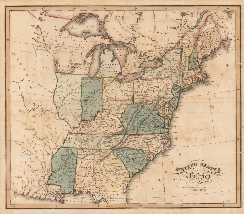
1819 Lizars Map of the United States
UnitedStates-lizars-1819$850.00

Title
United States of America.
1819 (undated) 16 x 18.25 in (40.64 x 46.355 cm) 1 : 6000000
1819 (undated) 16 x 18.25 in (40.64 x 46.355 cm) 1 : 6000000
Description
A rare 1819 map of the United States issued by William Lizars for David Baillie Warden's Statistical, Political, and Historical Account of the United States of America. The map illustrates the early days of the westward expansion prior to the Texas Revolution, the Mexican-American War, and the Trail of Tears.
A Closer Look
Coverage embraces from the Missouri Territory to the Atlantic Seaboard and from the Great Lakes to northern Florida and the Gulf of Mexico. Cartographic detail drops off sharply west of the Mississippi, where it is limited to Native American villages on major river systems. To the east of the Mississippi the United States is divided into color coded states. Topography and major road networks are illustrated. It is of note that some major centers such as Columbus and Detroit are accessible only via river. Georgia and Alabama Territory are of interest as they illustrate American Indian settlements and towns prior to the 1830 Indian Removal Act and the subsequent Trail of Tears.Publication History and Census
This map was engraved and printed by William Lizars for David Baillie Warden's (1772 - 1845) Statistical, Political, and Historical Account of the United States of America. Examples of the full book are scarce, even more so with the present map. We see no history of the separate map on the market.Cartographer
William Home Lizars (May 4, 1788 - March 30, 1859) was a mapmaker, engraver, draughtsman, lithographer, copperplate printer, painter, and publisher active in Edinburgh, Scotland. Born in Edinburgh to Daniel Lizars (1754 - 1812) and his wife Margaret Home, William apprenticed to his father (an engraver and publisher) in 1802. Beginning in 1804, he began studying at the Trustees' Academy and began a career as a painter. After his father died in 1812, William took over the family business, abandoning his promising career as a painter. William worked in partnership with his brother Daniel Lizars (May 24, 1793 - March 14, 1875) from 1812 until the partnership was formally dissolved on October 21, 1819. William published a jigsaw puzzle in 1822 that may have been the first jigsaw puzzle produced in Scotland. After William's death, William and Alexander Keith Johnston acquired the firm, launching another great cartographic firm. William married Henrietta Wilson in 1820. After leaving the partnership, William's brother Daniel became a bookseller. In 1832, he went bankrupt and in 1833 emigrated to Canada. He died in Ontario in 1875. More by this mapmaker...
Source
Warden, David Baillie, Statistical, Political, and Historical Account of the United States of America, (Edinburgh: A. Constable; Philadelphia: T. Wardle) 1819.
Condition
Good. Foxing and acid burn. Stabilized on verso with archival tissue.