
This item below is out of stock, but another example (left) is available. To view the available item, click "Details."
Details
1862 Mitchell Map of the United States w/Confederate Arizona
1862 (dated) $350.00
1861 Mitchell Map of the United States
UnitedStates-mitchell-1861$225.00

Title
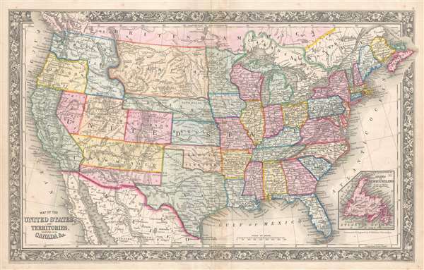
Map of the United States and Territories. Together with Canada etc.
1860 (dated) 14 x 22.25 in (35.56 x 56.515 cm) 1 : 10000000
1860 (dated) 14 x 22.25 in (35.56 x 56.515 cm) 1 : 10000000
Description
This is a Samuel Augustus Mitchell, Jr. map of the United States during the first year of the American Civil War which illustrates the ephemeral Confederate Arizona Territory and is one of the first maps to include the newly-formed Colorado Territory and Dakota Territory. Depicting the continental United States from the Pacific Ocean to the Atlantic Ocean and from Canada to Mexico and the Gulf of Mexico, this map captures the unique and volatile nature of the year 1861 in the history of the United States.
Confederate Arizona
Confederate Arizona was a territory claimed by the Confederate States of America from 1861 until 1865. The idea for an Arizona Territory appears as early as 1856, when the government of the Territory of New Mexico began to express concerns about being able to effectively govern the southern part of the territory, as it was separated from Santa Fe by the Jornada del Muerto, a particularly unforgiving stretch of desert. The New Mexico territorial legislature acted on these concerns in February 1858, approving a resolution in favor of creating an Arizona Territory, with a north-south border to be defined along the 32nd parallel. Impatiently waiting for Congress to approve the creation of the new territory, 31 delegates met at a convention in Tucson in April 1860 and drafted a constitution for the 'Territory of Arizona', which was to be organized out of the New Mexico Territory below 34th parallel. The convention even elected a territorial governor and a delegate to Congress. Congress, however, was reluctant to act. Anti-slavery Representatives knew that the proposed territory was located below the line of demarcation set forth by the Missouri Compromise for the creation of new slave and free states, and they were not inclined to create yet another slave state. Thus, Congress never ratified the proceedings of the Tucson convention, and the Provisional Territory was never considered a legal entity.
At the beginning of the Civil War, support for the Confederacy ran high in the southern parts of the New Mexico Territory. Local concerns drove this sentiment, including a belief that the war would lead to an insufficient number of Federal troops to protect the citizens from the Apache, while others simply felt neglected by the government in Washington. Also, the Butterfield Overland Mail Route (an overland mail and stagecoach route from Memphis and St. Louis to San Francisco) was closed in 1861, depriving the people of Arizona of their connection to California and the East Coast.
All of these factors led to the people of the southern New Mexico Territory, or the Arizona Territory, to formally call for secession, and a convention adopted a secession ordinance on March 16, 1861, with a subsequent ordinance ratified on March 28, establishing the provisional territorial government of the Confederate 'Territory of Arizona'. The Confederate Arizona Territory was officially proclaimed on August 1, 1861 following Lieutenant-Colonel J. R. Baylor's victory over Union forces in the First Battle of Mesilla, and the territory was officially recognized by the government of the Confederacy on February 14, 1862. However, by July 1862, Union forces from California, known as the 'California Column' were marching on the territorial capital of Mesilla. Sent to protect California from a possible Confederate incursion, the 'California Column' drove Confederate forces out of the city, allowing them to retreat to Franklin, Texas. The territorial government fled as well and spent the rest of the war in 'exile'. First, they retreated to Franklin, then, after Confederate forces abandoned Franklin and all of West Texas, to San Antonio, where the 'government-in-exile' would spend the rest of the war. Confederate units from Arizona would fight for the rest of the war, and the delegate from Arizona attended both the First and Second Confederate Congresses.
Territorial Changes in the northern Plains and the first Mitchell map to depict Colorado
The year 1861 saw major territorial changes in the northern plains. The Kansas-Nebraska Act, signed on May 30, 1854 created the Nebraska Territory, which originally stretched from the 40th parallel to the 49th parallel and from the Continental Divide to the White Earth and Missouri Rivers. In 1861, however, both the Colorado territory (which was formed on February 28) and the Dakota Territory (created on March 2) were created out of land originally part of the Nebraska Territory. Thus, this map is the first Mitchell map to illustrate the state of Colorado (as its territorial boundaries and its state boundaries are the same) and the Dakota Territory. Nebraska's extended panhandle would be lost in 1863, with the formation of the Idaho Territory, which would also include all the land in the Washington Territory east of Washington State's modern-day eastern border.
Communication, Transportation and Other Notations
Aside from illustrating the incredible historical moment detailed in the proceeding paragraphs, this map contains numerous other important elements. One such element is the illustration of the route of the Pony Express, a transcontinental mail route consisting of 186 different 'stations' separated by ten miles operated by 120 riders and over 400 horses. Operating for eighteen months, the Pony Express was the main communication route to California after the beginning of the Civil War until October 24, 1861, when the first transcontinental telegraph was established. The rail network throughout the United States is also illustrated. It appears that lines that were in operation in 1861 are illustrated by dark black lines, while proposed routes are indicated by dashed lines due to the presence of each of the proposed transcontinental routes, the first of which would not be completed until 1869. Myriad cities and towns throughout the country are labeled, including the state and territorial capitals and Washington, D.C. Innumerable rivers snake their way across the U.S., along with numerous mountains ranges. Both 'Canada East' (Quebec) and 'Canada West' (Ontario) are also labeled, along with New Brunswick, Nova Scotia, Prince Edward Island, and 'British America', or the rest of modern-day Canada. An inset map of Newfoundland is situated in the lower right corner. The whole is surrounded by Mitchell's distinctive flower border, common to Mitchell's atlases from 1860-1867.
This map was engraved by W. Williams and published by Samuel Augustus Mitchell, Jr. in the 1861 edition of his New General Atlas.
CartographerS
Samuel Augustus Mitchell (March 20, 1792 - December 20, 1868) began his map publishing career in the early 1830s. Mitchell was born in Bristol, Connecticut. He relocated to Philadelphia in 1821. Having worked as a school teacher and a geographical writer, Mitchell was frustrated with the low quality and inaccuracy of school texts of the period. His first maps were an attempt to rectify this problem. In the next 20 years Mitchell would become the most prominent American map publisher of the mid-19th century. Mitchell worked with prominent engravers J. H. Young, H. S. Tanner, and H. N. Burroughs before attaining the full copyright on his maps in 1847. In 1849 Mitchell either partnered with or sold his plates to Thomas, Cowperthwait and Company who continued to publish the Mitchell's Universal Atlas. By about 1856 most of the Mitchell plates and copyrights were acquired by Charles Desilver who continued to publish the maps, many with modified borders and color schemes, until Mitchell's son, Samuel Augustus Mitchell Junior, entered the picture. In 1859, S.A. Mitchell Jr. purchased most of the plates back from Desilver and introduced his own floral motif border. From 1860 on, he published his own editions of the New General Atlas. The younger Mitchell became as prominent as his father, publishing maps and atlases until 1887, when most of the copyrights were again sold and the Mitchell firm closed its doors for the final time. More by this mapmaker...
Wellington Williams (1814 - July 8, 1875) was an American engraver based in Germantown, Philadelphia. Williams was born in Bath, England. He emigrated to England as a young man, establishing himself in Philadelphia as a map and line engraver. He most notably engraved the maps for both Samuel Augustus Mitchell and his son, Samuel Augustus Mitchell Jr. There is some evidence that Williams resented the relationship and derived little profit from the success of two Mitchell atlases. He also engraved for William C. Woodbrid and D. Appleton. In addition, Williams also published several maps and views under his own imprint. His home was located at 1857 Mervine Street, 20th Ward, Philadelphia. His offices were located in Philadelphia, on 5th Street, below Chestnut. He was interred at the Laurel Hill Cemetery, Philadelphia. Learn More...
Source
Mitchell, S. A., Mitchell's New General Atlas Containing Maps of the Various Countries of the World, Plans of Cities, Etc., embraced in Forty-Seven Quarto Maps, Forming a series of Seventy-Six Maps and Plans, together with Valuable Statistical Tables (Philadelphia: S. Augustus Mitchell, Jr.) 1861.
Mitchell's New General Atlas was published by Samuel Augustus Mitchell, Jr., the son of the prolific cartographer Samuel Augustus Mitchell. Many of the plates are derived from the his father's Mitchell's Universal Atlas, but not directly. The Mitchell's Universal Atlas was initially sold to Thomas, Cowperthwait, and Company in 1849, and again to Charles Deliver in 1856. It was Deliver who introduced the new vibrant color scheme, abandoning the older Mitchell's Universal Atlas green borders and themes for bright reds, blues, and yellows. Samuel Augustus Mitchell, Jr. acquired the Deliver plates in 1859. He added his own floral motif border, but doubled down on the vibrant color scheme, thus introducing to the American public the most vividly colored American atlas of the 19th century. In 1860, he published the first edition of his New General Atlas and, despite a slump in sales during the American Civil War, attained a level of success to rival his father. Mitchell would continue to publish the New General Atlas until 1887, when the firm formally closed.
Condition
Very good. Light toning and transferrence along original centerfold. Blank on verso.