This item has been sold, but you can get on the Waitlist to be notified if another example becomes available, or purchase a digital scan.
1863 Mitchell Map of the United States
UnitedStates-mitchell-1863$125.00

Title
Map of the United States, and Territories. Together with Canada etc.
1860 (dated) 14.25 x 22.25 in (36.195 x 56.515 cm) 1 : 10000000
1860 (dated) 14.25 x 22.25 in (36.195 x 56.515 cm) 1 : 10000000
Description
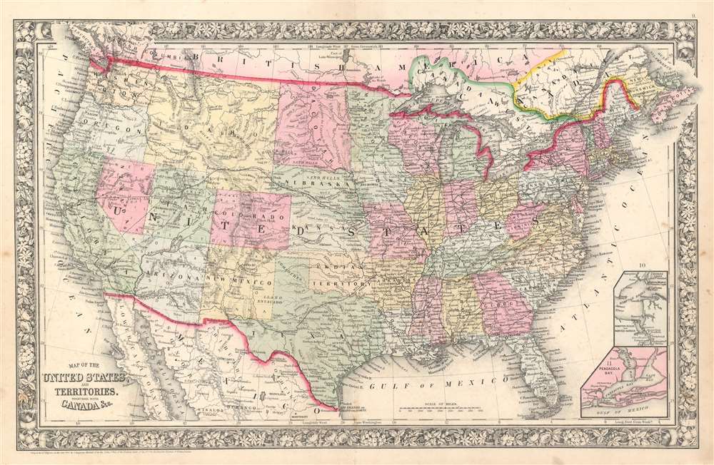
This is an 1863 Samuel Augustus Mitchell, Jr. map of the United States. The map depicts the region from the Pacific Ocean to the Atlantic Ocean and Nova Scotia and from Canada to Mexico. An ephemeral configuration of the western states is illustrated here, with Washington State and Oregon occupying basically the same borders that they do today, but Idaho takes up the entirety of the modern-day state of Idaho as well as Montana and Wyoming. North and South Dakota have yet to be established, leaving that region to be simply named Dacotah. Arizona stretches out along the 36th parallel to the California border, cutting into a large portion of southern modern day Nevada, including Las Vegas.
Apart from the geographical differences between the borders of today's states and those of 1863, a wealth of other details are included here. Innumerable cities and towns are labeled, as are forts, lakes, rivers, and waterfalls. The railroad network in the eastern states is illustrated by solid black lines that had not yet reached out west. There, the famous Pony Express Route is identified, as is the Mail Route through Texas, New Mexico, and Arizona to California. Other trails, such as the Route to Santa Fe and the Wagon Road to Salt Lake from Southern California are also illustrated. Two inset maps situated in the lower right corner illustrate Hampton Roads and Pensacola Bay.
Apart from the geographical differences between the borders of today's states and those of 1863, a wealth of other details are included here. Innumerable cities and towns are labeled, as are forts, lakes, rivers, and waterfalls. The railroad network in the eastern states is illustrated by solid black lines that had not yet reached out west. There, the famous Pony Express Route is identified, as is the Mail Route through Texas, New Mexico, and Arizona to California. Other trails, such as the Route to Santa Fe and the Wagon Road to Salt Lake from Southern California are also illustrated. Two inset maps situated in the lower right corner illustrate Hampton Roads and Pensacola Bay.
Publication History
This map was created and published by Samuel Augustus Mitchell, Jr. for publication in the 1863 edition of his New General AtlasCartographer
Samuel Augustus Mitchell (March 20, 1792 - December 20, 1868) began his map publishing career in the early 1830s. Mitchell was born in Bristol, Connecticut. He relocated to Philadelphia in 1821. Having worked as a school teacher and a geographical writer, Mitchell was frustrated with the low quality and inaccuracy of school texts of the period. His first maps were an attempt to rectify this problem. In the next 20 years Mitchell would become the most prominent American map publisher of the mid-19th century. Mitchell worked with prominent engravers J. H. Young, H. S. Tanner, and H. N. Burroughs before attaining the full copyright on his maps in 1847. In 1849 Mitchell either partnered with or sold his plates to Thomas, Cowperthwait and Company who continued to publish the Mitchell's Universal Atlas. By about 1856 most of the Mitchell plates and copyrights were acquired by Charles Desilver who continued to publish the maps, many with modified borders and color schemes, until Mitchell's son, Samuel Augustus Mitchell Junior, entered the picture. In 1859, S.A. Mitchell Jr. purchased most of the plates back from Desilver and introduced his own floral motif border. From 1860 on, he published his own editions of the New General Atlas. The younger Mitchell became as prominent as his father, publishing maps and atlases until 1887, when most of the copyrights were again sold and the Mitchell firm closed its doors for the final time. More by this mapmaker...
Source
Mitchell Jr., S. A., Mitchell's New General Atlas, containing Maps of the Various Countries of the World, Plans of Cities, Etc., Embraced in Fifty-five Quarto Maps, forming a series of Eighty-Seven Maps and Plans, together with Valuable Statistical Tables. 1863 Edition.
Mitchell's New General Atlas was published by Samuel Augustus Mitchell, Jr., the son of the prolific cartographer Samuel Augustus Mitchell. Many of the plates are derived from the his father's Mitchell's Universal Atlas, but not directly. The Mitchell's Universal Atlas was initially sold to Thomas, Cowperthwait, and Company in 1849, and again to Charles Deliver in 1856. It was Deliver who introduced the new vibrant color scheme, abandoning the older Mitchell's Universal Atlas green borders and themes for bright reds, blues, and yellows. Samuel Augustus Mitchell, Jr. acquired the Deliver plates in 1859. He added his own floral motif border, but doubled down on the vibrant color scheme, thus introducing to the American public the most vividly colored American atlas of the 19th century. In 1860, he published the first edition of his New General Atlas and, despite a slump in sales during the American Civil War, attained a level of success to rival his father. Mitchell would continue to publish the New General Atlas until 1887, when the firm formally closed.
Condition
Very good. Even overall toning. Light soiling. Wear along original centerfold. Verso repair to centerfold separation. Blank on verso.