This item has been sold, but you can get on the Waitlist to be notified if another example becomes available, or purchase a digital scan.
1850 Tallis Map of the United States ( Texas at fullest extent)
UnitedStates-tallis-1850$250.00

Title
United States.
1850 10 x 13.5 in (25.4 x 34.29 cm)
1850 10 x 13.5 in (25.4 x 34.29 cm)
Description
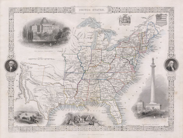
This is John Tallis's highly desirable 1850 Map of the United States. This is the earliest variation on this map that includes Texas as a state. Herein Texas is depicted at near its fullest extent including both Santa Fe and but excluding the Green Mountain extension in the Northwest. Wisconsin and Iowa are shown with amorphous boundaries. Offers several beautiful vignettes depicting the Baltimore Washington Monument, The Capitol in Washington D.C., Penn's Treaty with the Indians, and an American Indian Buffalo Hunt on the Great Plains. The upper right quadrant features a U.S. flag shield and an Excelsior seal. The ornate border includes the portraits of Washington and Franklin. Undated, but the form of Texas allows us to positively date this to the early 1850 issue of Tallis's valuable map.
Cartographer
John Tallis and Company (1838 - 1851) published views, maps, and atlases in London from roughly 1838 to 1851. Their principal works, expanding upon the earlier maps of John Cary and Aaron Arrowsmith, include an 1838 collection of London Street Views and the 1849 Illustrated Atlas of the World. The firm’s primary engraver was John Rapkin, whose name and decorative vignettes appear on most Tallis maps. Due to the embellishments typical of Rapkin's work, many regard Tallis maps as the last bastion of English decorative cartography in the 19th century. Although most Tallis maps were originally issued uncolored, it was not uncommon for 19th century libraries to commission colorists to "complete" the atlas. The London Printing and Publishing Company of London and New York bought the rights for many Tallis maps in 1850 and continued issuing his Illustrated Atlas of the World until the mid-1850s. Specific Tallis maps later appeared in innumerable mid to late-19th century publications as illustrations and appendices. More by this mapmaker...
Condition
Fine or perfect condition. Blank on verso.
References
Phillips, 804-70.; Rumsey 0466.071.