This item has been sold, but you can get on the Waitlist to be notified if another example becomes available, or purchase a digital scan.
1829 Tanner First Edition Wall Map of the United States w/ Memoir
UnitedStates-tanner-1829-2$4,250.00


Title
United States of America.
1829 (dated) 46 x 60 in (116.84 x 152.4 cm) 1 : 2000000
1829 (dated) 46 x 60 in (116.84 x 152.4 cm) 1 : 2000000
Description
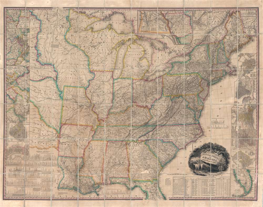
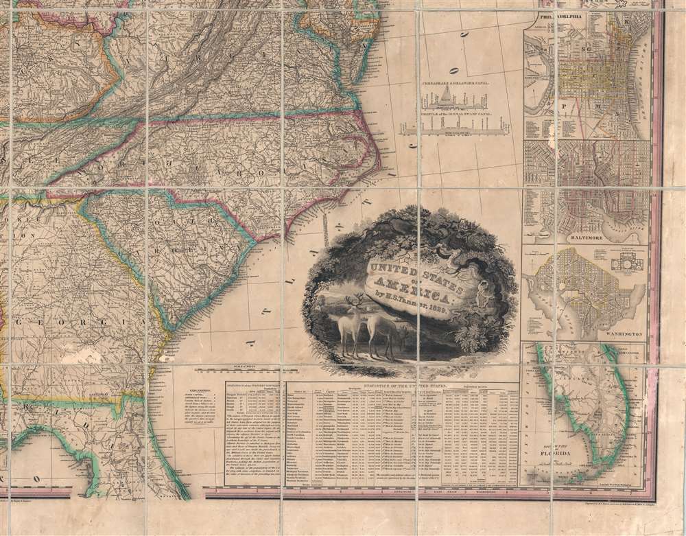
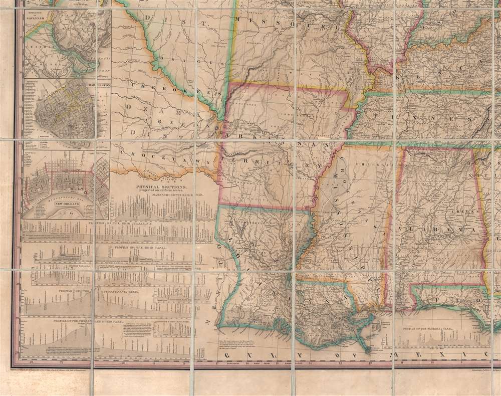
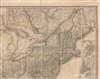
This, the first edition of Henry Schenck Tanner's 1829 wall map of the United States, is one of the most important American maps of the 19th century. With this important map Tanner initiated a new age of quintessentially American cartography. Unlike his predecessors, John Melish and Matthew Carey, Tanner was born and raised in the United States, and his maps are uniquely American productions, embracing American values and interests. Note the cartouche, with two deer grazing in a dense forest, while in the background three miniscule trains steam westward - a fitting metaphor for the United States, at the time undergoing brisk industrialization fueled by unlimited natural resources. Within the historical context, this map follows the territorial acquisitions of the 1819 Adams-Onís Treaty (Florida, Oregon?), but predates the major expansions in the southwest following the Mexican-American War (1846 - 1848) and the Treaty of Guadalupe-Hidalgo (1848).
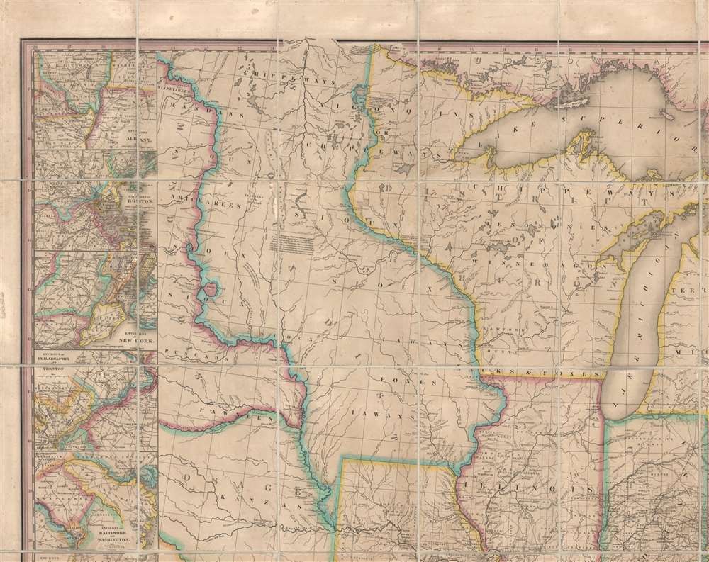
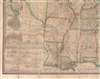
Tanner identifies American Indian nations as 'districts,' particularly in the Trans-Mississippi. These include the Huron District, Sioux District, Mandan District, Osage District, and Ozark District, among others. He also includes all major roadways as well as distance measurements between towns - a useful detail which the accompanying memoir notes caused the map to take twice as long to prepare.
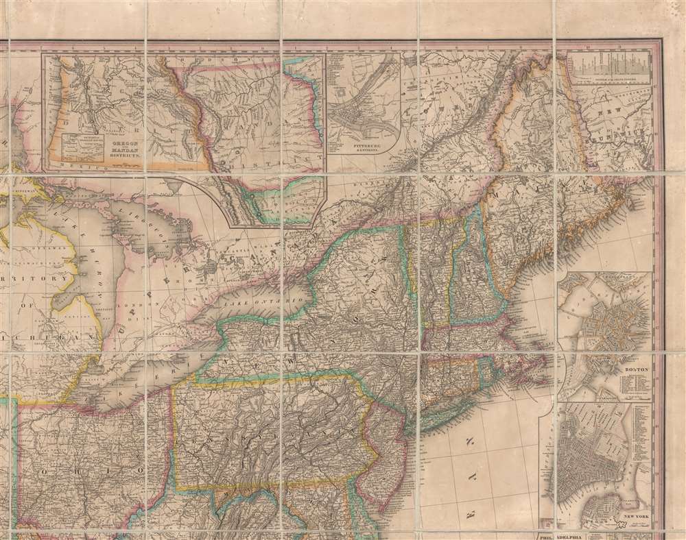
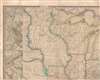
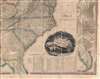
The whole is surrounded by fourteen inset maps detailing various American cities. These include the Environs of Albany, Environs of Boston, Environs of New York, Environs of Philadelphia and Trenton, Environs of Baltimore and Washington, Cincinnati, Charleston, New Orleans, Washington, Baltimore, Philadelphia, New York, Boston, and Pittsburg and Environs, as well and regional maps detailing south Florida and Oregon and the Mandan District.
This last inset, 'Oregon and Mandan Districts' is particularly significant as the first appearance of the name 'Oregon' on a map. There is a secondary sub-inset within this larger map entitled 'Outlet of the Oregon River.' In this case, the Oregon is the modern day 'Columbia River'.
We offer this map accompanied by the corresponding first edition of Tanner's fascinating Memoir on the Recent Surveys, Observations, and Internal Improvements in the United States in which he expounds upon his research, sources, and the production process.
Scholars Laud the Map
Ristow writes,Tanner undertook the ambitious task of compiling a large map, the United States of America, which he copyrighted on June 10, 1829. It is at the scale of 1:2,000,000, somewhat larger than Melish's 1816 map of the United States. . . Tanner's United States of America has thirteen inset maps, principally of cities and their environs, a statistical table, and profiles of a number of canals and railroad rights of way…Rumsey refers to the map as 'one of best early large maps of the United States and the premier map for its period.'
A Closer Look
The map covers from the Missouri River in the vicinity of Fort Mandan eastward to the Atlantic seaboard and from the Great Lakes to the Mississippi Delta. South Florida is included via an inset appearing on the lower right. The Pacific Northwest, including Oregon, as well as modern day Idaho, Washington, Montana, and Wyoming, are continued in an inset at top center, just above Lake Huron.Tanner identifies American Indian nations as 'districts,' particularly in the Trans-Mississippi. These include the Huron District, Sioux District, Mandan District, Osage District, and Ozark District, among others. He also includes all major roadways as well as distance measurements between towns - a useful detail which the accompanying memoir notes caused the map to take twice as long to prepare.
The whole is surrounded by fourteen inset maps detailing various American cities. These include the Environs of Albany, Environs of Boston, Environs of New York, Environs of Philadelphia and Trenton, Environs of Baltimore and Washington, Cincinnati, Charleston, New Orleans, Washington, Baltimore, Philadelphia, New York, Boston, and Pittsburg and Environs, as well and regional maps detailing south Florida and Oregon and the Mandan District.
This last inset, 'Oregon and Mandan Districts' is particularly significant as the first appearance of the name 'Oregon' on a map. There is a secondary sub-inset within this larger map entitled 'Outlet of the Oregon River.' In this case, the Oregon is the modern day 'Columbia River'.
We offer this map accompanied by the corresponding first edition of Tanner's fascinating Memoir on the Recent Surveys, Observations, and Internal Improvements in the United States in which he expounds upon his research, sources, and the production process.
Publication History and Census
Tanner engraved this map with assistance by E. B. Dawson, W. Allen, and J. Knight. The title cartouche was engraved by J. W. Steel. Tanner's map proved both useful and popular, with several editions to follow. Rumsey notes editions in 1829 (present example), 1830, 1832, 1834, 1836, 1838, 1839, 1841, 1843, 1844, 1845, and 1850. It is likely that Tanner derived some of the basic cartography from J. and A. Walker's map of the United States which was published in London two years prior. Regardless, this was the premier map of the United States until superseded by Mitchell's map of 1834.CartographerS
Henry Schenck Tanner (1786 - May 18, 1858) was one of the preeminent American map engravers and publishers of the early 19th century - what is considered to be the "Golden Age of American Map Publishing". Born in New York City but based in Philadelphia, Tanner's forty plus year career was almost entirely focused on cartographic work. His earliest map work appears in conjunction with another important map publisher, John Melish. Early in his career, Tanner partnered with his brother Benjamin, to engrave extensively for Melish as well as other Philadelphia publishers including Lucas Fielding (Baltimore), A. Bourne, Jason Torey, Samuel Harrison, and Samuel Lewis, among others. In 1818 Tanner convinced his fellow publishers and partners to finance the compilation of a New American Atlas. The atlas was sold by subscription and slowly emerged between 1819 and 1823. The New American Atlas, possibly the pinnacle of 19th century American cartography and was commended in its day as "one of the most splendid works of the kind ever executed in this country". It was subsequently republished in several updated editions until about 1839. Tanner had by this time become the most active and influential map publisher in the United States. Around 1832, recognizing the market for a less cost prohibitive atlas, Tanner began work on the smaller format New Universal Atlas. This popular and important atlas went through numerous editions before being bought out by Carey and Hart, and then, in 1846, by S. A. Mitchell, who would rise to become the preeminent publisher of the next generation. In addition to these important atlases, Tanner also issued numerous extremely important and influential travelers guides, state maps, wall maps, and pocket maps. He should not be confused with his brother, also an America map engraver, the New Yorker Benjamin Tanner. More by this mapmaker...
James White Steel (April 27, 1799 - February 16, 1882) was an American engraver, landscape artist, and portraitist active in Philadelphia throughout most of the 19th century. Steel was born in Philadelphia and mastered line and stipple engraving under Benjamin Tanner (1775 - c. 1846) and George Murray. In addition to his own work, he engraved for B. Tanner's brother, Henry Schenck Tanner (1786 - 1858). Learn More...
W. Allen (fl. 1825 - 1835) was a line and stipple engraver active in Philadelphia in the early to mid-19th century. He engraved with the Henry Schenck Tanner (1786 - 1858) firm. Learn More...
Edward B. Dawson (fl. c. 1820 - 1830) was an American engraver active in Philadelphia during the middle part of the 19th century. Dawson engraved extensively for the mapmaking firm of Henry Schenck Tanner (1786 - 1858). Learn More...
John Knight (1802 - 1872) was an American line and letter engraver based in Philadelphia and Delaware. He worked with Henry Schenck Tanner (1786 - 1858) and late for the U.S. Coast Survey. Learn More...
Condition
Very good. Dissected and mounted on linen by publisher. Original linen backing replaced with fresh inert linen. Some scuffing near Georgia. Accompanied by Tanner's memoir in 1/4 Red Morocco. Memoir exhibits moderate spotting and foxing.
References
Rumsey 0975.001. Phillips (America) page 885. Howes T28. Ristow, W., American Maps and Mapmakers, p. 198. American Imprints (1829) 40603. Phillips, America, p. 885. Rumsey 975000. Streeter Sale 3835. Wheat, C. I., Mapping of the Transmississippi West, 1540 – 1861, #390, p. 94 (illustrated), p. 96. Boston Public Library, Leventhal Collection, G3700 1829 .T3. Schwartz, S. and Ehrenberg, R., The Mapping of America, p. 253.