This item has been sold, but you can get on the Waitlist to be notified if another example becomes available, or purchase a digital scan.
1833 Willis Thrall Map of the United States (Manifest Destiny)
UnitedStates-thrall-1833$1,250.00

Title
Map of the United States Compiled from the most Authentic Sources.
1833 (dated) 20.5 x 27 in (52.07 x 68.58 cm) 1 : 7000000
1833 (dated) 20.5 x 27 in (52.07 x 68.58 cm) 1 : 7000000
Description
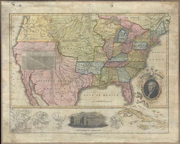
This is a fascinating 1833 wall map of the United States published in Hartford, Connecticut, by Willis Thrall. In an unusual flourish for the time, Thrall's map covers the United States from Coast to Coast, extending from Oregon to the Atlantic and from Canada to Mexico. As this map predates the Texas Revolution, the Mexican American War, and the Treaty of Guadeloupe-Hidalgo, all of the southwest, including California, Arizona, New Mexico, Nevada, Utah, and Texas are part of Mexico.
The map is most interested in its illustration of the western territories. Oregon Territory extends from California to Canada, apparently extending beyond the maps border. Similarly, a vast Missouri territory extends from the Arkansas River north to beyond the map's border. The northwest territory, with a large Buffalo Plains, occupies modern day Wisconsin and parts of Minnesota. The route of Lewis and Clark to the Pacific is noted. In Arkansas, what is today Little Rock, then William Lewis's fledgling community, is identified as Arkopolis.
The map features a beautifully stippled image of George Washington in the lower right corner. Below the map is an illustration of the Capitol Building, and submaps of Washington DC, New York City, Boston, and North America. At the far right the map extends south of the border to include the Greater Antilles.
Cartographically this map is derived from a similar map issued in 1826 by Asaph Willard and Eleazer Huntington. Thrall acquired the plates in 1829 and revised them somewhat for republication under his own imprint. As such this map represents the fourth or fifth state of the second edition. It is unclear exactly which state this map represents. This map must have had a small print run, as today all editions are quite rare.
Cartographer
Willis Thrall (1800 - June 20, 1884) was an American businessman and map publisher based in Hartford Connecticut during the early part of the 19th century. His the son of Joel Thrall and Miriam Fitch, both of Both Bolton Connecticut. Thrall published numerous maps and also seems to have opened a tool and rule company in 1844, which he passed on to his son, Edward Thrall, as 'Will Thrall and Son'. No Thrall engravings appear after about 1836, suggesting he gave on on printing, but the tool company seems to have prospered. Thrall's most important print work was published in conjunction with D. W. Kellogg, with whom his family was associated by marriage. Thrall died in June of 1884 and is inferred at Spring Grover Cemetery, Hartford. More by this mapmaker...
Condition
Very good. Full professional restoration including fresh linen backing. Lower left corner reinstated in manuscript. Soiling to border.
References
Rumsey 1008.00. Wheat, C. I., Mapping of the Transmississippi West, 1540 – 1861, 407.