1776 Lotter Map of the United States at the Outbreak of the Revolutionary War
UnitedStatesAmeriqueAngloise-lotter-1776-3$1,700.00
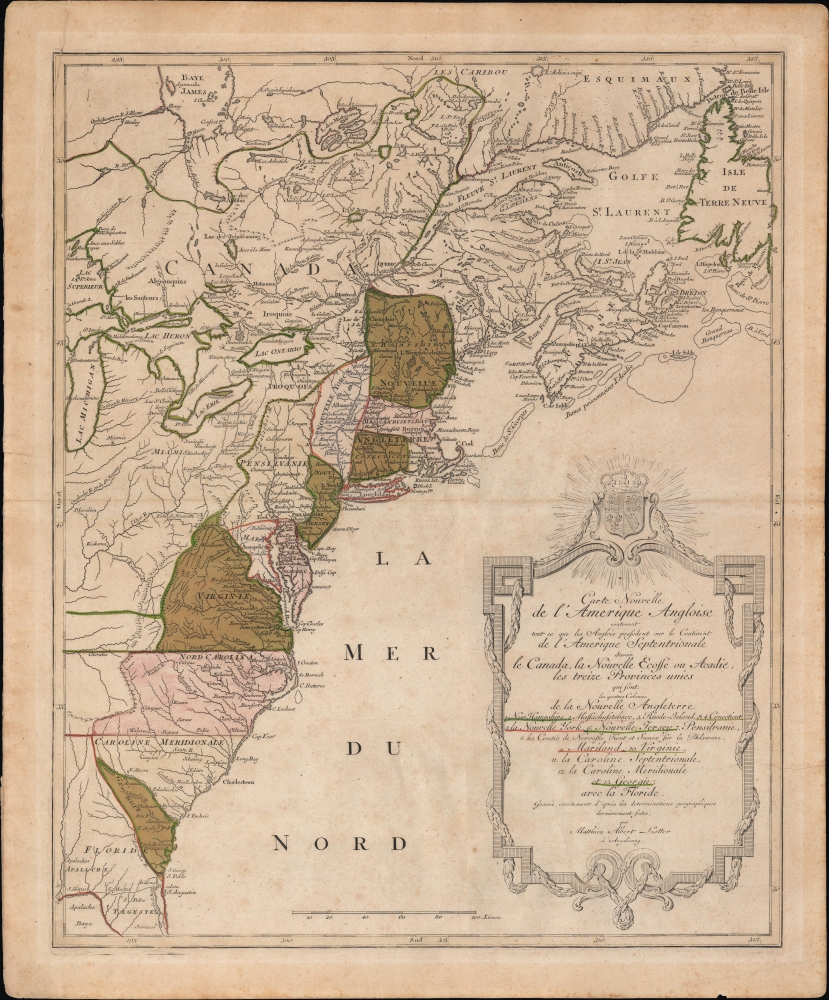

Title
Carte Nouvelle de L'Amerique Angloise contenant tout ce que les Anglois possedent sur le Continent de L'Amerique Septentrionale savoir le Canada, la Nouvelle Ecosse ou Acadie, les treize Provinces unies
1776 (undated) 24 x 19.5 in (60.96 x 49.53 cm) 1 : 4500000
1776 (undated) 24 x 19.5 in (60.96 x 49.53 cm) 1 : 4500000
Description
An uncommon French-language 1776 Mathais Albrecht Lotter map of the American colonies on the cusp of the American Revolutionary War.
The Thirteen Colonies are presented in detail, although, in some cases, with curious borders. Of note are the unusual boundaries given to Maryland and Maine (at this point part of Massachusetts). Pennsylvania has been granted all of what is today western New York, as north far as the Finger Lakes - which is identified as Iroquois territory. Vermont has yet to manifest.
West of the Appalachian Mountains, the map offers uncommon detail in the Ohio Valley, including American Indian settlements and forts related to the French and Indian War (1754 - 1763). These include Fort de Necessite, Logs Town, Twictwees, Ft. Du Quesne, Allegheny, Vinango, Buffaloons, Sandoski, and Mingos.
An exceptionally large and elaborate title cartouche dramatically fills the lower right quadrant. The text, as previously mentioned, is in French, as is the content of the map, including an individual naming of the Thirteen Colonies (and Florida). The title text is bordered by an elaborate rococo frame surmounted by the armorial crest of the United Kingdom.
Curiously, the only exception to this convention on Lotter's map is the presentation, in reference to North Caronia and Virginia, of secondary boundaries extending westward beyond the scope of the map in accordance with the original royal charters of these two colonies. This is a convention we have seen before, although the intent of the cartographer here is unclear. Perhaps, in the name of scientific impartiality, Lotter is attempting to represent both French and British perspectives?
A Closer Look
Focused on the Thirteen British Colonies, this map covers from Florida to Newfoundland and Hudson Bay, and extends westward as far as Lake Michigan, including all five of the Great Lakes (only 1/2 of Lake Superior). Some offshore details are noted, particularly the fishing banks off the coasts of North Carolina, Massachusetts, Nova Scotia, and Newfoundland.The Thirteen Colonies are presented in detail, although, in some cases, with curious borders. Of note are the unusual boundaries given to Maryland and Maine (at this point part of Massachusetts). Pennsylvania has been granted all of what is today western New York, as north far as the Finger Lakes - which is identified as Iroquois territory. Vermont has yet to manifest.
West of the Appalachian Mountains, the map offers uncommon detail in the Ohio Valley, including American Indian settlements and forts related to the French and Indian War (1754 - 1763). These include Fort de Necessite, Logs Town, Twictwees, Ft. Du Quesne, Allegheny, Vinango, Buffaloons, Sandoski, and Mingos.
An exceptionally large and elaborate title cartouche dramatically fills the lower right quadrant. The text, as previously mentioned, is in French, as is the content of the map, including an individual naming of the Thirteen Colonies (and Florida). The title text is bordered by an elaborate rococo frame surmounted by the armorial crest of the United Kingdom.
Know Your Audience
Lotter, a German cartographer based in Augsburg, no doubt intended this map to capitalize on popular French interest in the American Revolution. The elaborate title text is composed entirely in French - unusual for Lotter - and the geographical deportment of the colonies themselves betray a distinctly Franco-centric perspective. Despite the French losing their North American territories in 1763, at the end of the French and Indian War, they no doubt maintained certain prejudices regarding the limits of British claims. Such is reflected in the French pre-French and Indian War convention, exemplified here, of restricting the Thirteen Colonies to those lands east of the Appalachian Mountains.Curiously, the only exception to this convention on Lotter's map is the presentation, in reference to North Caronia and Virginia, of secondary boundaries extending westward beyond the scope of the map in accordance with the original royal charters of these two colonies. This is a convention we have seen before, although the intent of the cartographer here is unclear. Perhaps, in the name of scientific impartiality, Lotter is attempting to represent both French and British perspectives?
Publication History and Census
This map was prepared by Mathais Albrecht Lotter and published in Suetter's 1783 Grosser Atlas, as well as independently issued.CartographerS
Tobias Conrad Lotter (1717 - 1777) was a German engraver and map publisher. Lotter was the son of a baker and city guardsman, but married Euphrosina (1709 - 1784) Seutter, elder daughter of the prominent map publisher Matthäus Seutter. He began working at his is father-in-law's map business about 1740. Between 1740 and 1744 he produced, under Seutter's imprint, the Atlas minor, Praecipua orbis terrarum imperia, regna et provincias, Germania potissimum tabelli. Upon Seutter's death, in 1757, the firm's stock was taken over by his son, Albrecht Karl Seutter (1722 - 1762), who himself died in 1762, just a few years later. The remaining Seutter map plates were subsequently divided between Lotter and the publisher Johan Mitchell Probst (1727 - 1776). With the support of his sons, Matthäus Albrecht (1741 - 1810), Georg Friedrich (1744 - 1801) and Gustav Conrad (1746-1776), Tobias Conrad Lotter succeeded in building on the economic success and professional reputation of his father-in-law. In time, Lotter became one of the most prominent mid-18th century map publishers working in the German school. After Lotter's death in 1777, the business was taken over by his two eldest sons, who, lacking their father's business acumen, presided over the firm's slow decline. It was nonetheless passed on to a subsequent generation of Lotters, Matthäus Albrecht Lotter's sons, Gabriel (1776 - 1857) and Georg Friedrich (1787 - 1864), who pushed it into further decline until it faded out in the early-19th century. More by this mapmaker...
Matthäus Seutter (1678 - 1757) was one of the most important and prolific German map publishers of the 18th century. Seutter was born the son of a goldsmith but apprenticed as a brewer. Apparently uninspired by the beer business, Seutter abandoned his apprenticeship and moved to Nuremberg where he apprenticed as an engraver under the tutelage of the prominent J. B. Homann. Sometime in the early 1700s Seutter left Homann to return to Augsburg, where he worked for the prominent art publisher Jeremiad Wolff (1663 - 1724), for whom he engraved maps and other prints. Sometime around 1717 he established his own independent cartographic publishing firm in Augsburg. Though he struggled in the early years of his independence, Seutter's engraving skill and commitment to diversified map production eventually attracted a substantial following. Most of Seutter's maps are heavily based upon, if not copies of, earlier work done by the Homann and De L'Isle firms. Nonetheless, by 1731/32 Seutter was one of the most prolific publishers of his time and was honored by the German Emperor Karl VI who gave him the title of Imperial Geographer, after which most subsequent maps included the Avec Privilege designation. Seutter continued to publish until his death, at the height of his career, in 1757. Seutter had two engraver sons, Georg Matthäus Seutter (1710 - 173?) and Albrecht Carl Seutter (1722 - 1762). Georg Matthäus quit the business and relocated to Woehrdt in 1729 (and probably died shortly thereafter), leaving the family inheritance to his wastrel brother Albrecht Carl Seutter, who did little to advance the firm until in own death in 1762. Following Albrecht's death, the firm was divided between the established Johann Michael Probst (1727 - 1776) firm and the emerging firm of Tobias Conrad Lotter. Lotter, Matthäus Seutter's son-in-law, was a master engraver and worked tirelessly on behalf of the Suetter firm. It is Lotter, who would eventually become one of the most prominent cartographers of his day, and his descendants, who are generally regarded as the true successors to Matthäus Seutter. (Ritter, M. Seutter, Probst and Lotter: An Eighteenth-Century Map Publishing House in Germany., "Imago Mundi", Vol. 53, (2001), pp. 130-135.) Learn More...
Source
Lotter, M. A. and Seutter, G. M., Grosser Atlas, (Augsburg) 1783.
Condition
Good. Light soiling. Toning along centerfold. Wear in top-left corner from earlier folding.
References
OCLC 706063843. McCorkle, B. B, New England in Early Printed Maps 1513 - 1800, 776.19. Phillips (America) 3517. Sellers, John R. and Van Ee, Patricia, Maps and Charts of North America, 141.