1862 Johnson Military Map of the United States in Seven Departments
UnitedStatesMilitary-johnson-1862$400.00

Title
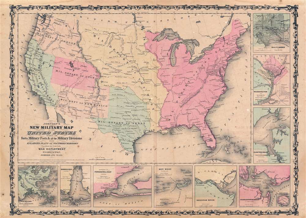
Johnson's New Military Map of the United States Showing the Forts, Military Posts, and all the Military Divisions with Enlarged Plans of Southern Harbors. From Authentic Data Obtained at the War Department.
1862 (undated) 17.5 x 24.25 in (44.45 x 61.595 cm) 1 : 10000000
1862 (undated) 17.5 x 24.25 in (44.45 x 61.595 cm) 1 : 10000000
Description
An exceptional example of A. J. Johnson's highly desirable 1862 Military Map of the United States. Created at the outbreak of the American Civil War, this map was issued by Johnson in order to capitalize on the general interest in the War. This is one the two significant variants. This variant, the earlier of the two, shows the U.S. Military Department as of 1861. It offers a wonderful insight into the political situation shortly following the outbreak of the American Civil War (1861 - 1865).
U.S. Military Departments and the American Civil War
The military districting system in the United States began around 1800, when the country was divided into 11 separately administered military zones. In the early days of westward expansion, these entities were often the only governmental authority patrolling vast regions. Later, as governing infrastructure developed, military district administration often co-existed with civil governments. The U.S. military districts were always somewhat fluid, changing, consolidating, or breaking apart, as required. On October 31, 1853, the division echelon was eliminated and the departments in the east became The Department of the East, administering all territory east of the Mississippi. The 6 western departments consolidated into 4, the Departments of Texas, New Mexico, the West, and the Pacific. The system returned to 6 departments in 1858 when the Department of Utah was created, and the Department of the Pacific split into the Departments of California and Oregon. This is the system represented on the 1861 and some 1862 editions of Johnson's military district maps. With the outbreak of the American Civil War (1861 - 1865), the once unified Military Department of the East became the theater of America's bloodiest war. The old Military Department system was exploded into smaller districts, often conforming to state-based Union armies.Publication History and Census
This map was first introduced in the 1861 Johnson and Browning New York edition of Johnson's New Illustrated Family Atlas. Unlike most or the map's in Johnson's atlas, which were derived from Colton's General Atlas, this map is a unique production issued in the midst of escalating tensions between the northern and southern states. There are two major editions of this map and numerous sub-states and variants. The first major edition, the present example, appeared in 1861 and some 1862 atlases, and featured the military department system in effect form 1858 to 1861 - in which there were several large divisions including a large Department of the East. The military department system was revised into a district system with the outbreak of the American Civil War, which exploded the department of the east into numerous smaller districts roughly corresponding to states - that variant appeared in Johnson atlases from 1862 to early 1865. After 1865, the military map was removed from all subsequent editions of the atlas. In total there are 8 states of the map, including minor variations on the two major editions. The present example is the 2nd state, used for part of 1862.Cartographer
Alvin Jewett Johnson (September 23, 1827 - April 22, 1884) was a prolific American map publisher active from 1856 to the mid-1880s. Johnson was born into a poor family in Wallingford, Vermont, where he received only a basic public education. He is known to have worked as a school teacher for several years before moving to Richmond, Virginia. Johnson got his first taste of the map business as a salesman and book canvasser for J. H. Colton. The earliest Johnson maps were published with D. Griffing Johnson (no clear relation) and date to the mid-1850s; however, it was not until 1860 that the Johnson firm published its first significant work, the Johnson's New Illustrated (Steel Plate) Family Atlas. The publication of the Family Atlas followed a somewhat mysterious 1859 deal with the well-established but financially strapped J. H. Colton cartographic publishing firm. Although map historian Water Ristow speculates that Colton sold his copyrights to Johnson and his business partner, another Vermonter named Ross C. Browning (1822 - 1899), a more likely theory is that Johnson and Browning financially supported the Colton firm in exchange for the right to use Colton's existing copyrighted map plates. Regardless of which scenario actually occurred, it is indisputable that the first Johnson atlas maps were essentially reissues of earlier Colton maps. Early on, Johnson described his firm as the 'Successors to J. H. Colton and Company'. Johnson's business strategy involved transferring the original Colton steel plate engravings to cheaper lithographic stones, allowing his firm to produce more maps at a lower price point. In 1861, following the outbreak of the American Civil War (1861 - 1865) Johnson and Browning split their firm between two offices. Johnson moved from Richmond, Virginia, to New York City. Browning remained in Richmond, where he published at least one more edition of the atlas in 1862, at the height of the war. Johnson and Browning published two editions of the Johnson Atlas: 1860 (Richmond and New York) and 1861 (Richmond and New York). Sometime in 1861, Browning's portion of the firm (or perhaps the New York portion?) was purchased by Benjamin P. Ward, whose name subsequently replaced Browning's on the imprint. The 1863 issue of the Family Atlas was one of the most unusual, it being a compilation of older 'Johnson and Browning' maps, updated 1862 'Johnson and Ward' maps, and newer 1863 maps with a revised border design. The 1864 issue of the Family Atlas is the first fully 'Johnson and Ward' atlas. Johnson published one more edition of the atlas in partnership with Ward in 1865, after which Johnson bought out Ward. The next issue of the atlas, 1866, is the first purely 'Johnson' atlas with all new map plates, updated imprints, and copyrights. The Family Atlas went through roughly 27 years of publication, from 1860 to 1887, outliving Johnson himself, who died in 1884. Johnson maps from the Family Atlas are notable for their unique borders, of which there are four different designs, the 'strapwork border' from 1860 to 1863, the 'fretwork border' from 1863 to 1869, the 'spirograph border' in 1870 to 1882, and a more elaborate version of the same from 1880 to 1887. In addition to the Family Atlas, Johnson issued numerous wall maps, pocket maps, and in the 1880s, the Cyclopedia. Johnson maps are known for their size, accuracy, detail, and stunning, vivid hand coloring. Johnson's maps, purely American in their style and execution, chronicle some of the most important periods in American history, including the Civil War, the Westward Expansion, and the Indian Wars. Today Johnson's maps, especially those of the American West, are highly sought after by map collectors and historians. More by this mapmaker...
Condition
Very good. Exhibits light wear along original centerfold. Exhibits some foxing. Verso repair to centerfold separation. Blank on verso.