This item has been sold, but you can get on the Waitlist to be notified if another example becomes available, or purchase a digital scan.
1861 Johnson Military Map of the United States in 7 Departments
UnitedStatesMilitary2-johnson-1861$200.00

Title
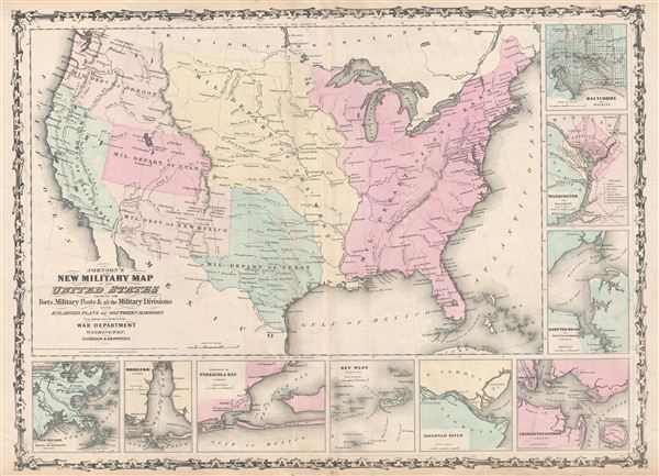
Johnson's New Military Map of the United States showing the Forts, Military Posts & all the Military Divisions with Enlarged Plans of Southern Harbors.
1861 (dated) 17.5 x 24 in (44.45 x 60.96 cm)
1861 (dated) 17.5 x 24 in (44.45 x 60.96 cm)
Description
A scarce and underappreciated 1861 map by A. J. Johnson showing the military deportment of the United States in 1860, just prior to the outbreak of the American Civil War. The map covers the entire United States and is broken up into various military departments. The map is surrounded on two sides by inset plans of 'southern harbors.' Though the Civil War had not yet broken out when Johnson drew this map, tensions where high and his choice to include strategic southern within his 'Military Map' was clearly intended profit from a general sense of anticipation. Insets include, from top right, Baltimore, Washington and Vicinity, Hampton Roads, Charleston Harbor, the Savannah River, Key West, Pensacola Bay, Mobile Bay, and New Orleans.
The military department system in the United States has a long and complex history. The department system was created by Secretary of War John C. Calhoun and Jefferson Davis in 1853. The present map references various changes to the department system at the outset of the American Civil War. When the war began there were but three military departments dating, most of which were organized for the Indian Wars. These included the Department of the east, the Department of the West, and the Department of the Pacific. The Department of the east was created in 1853 and initially constituted all of the lands east of the Mississippi River. In 1861 this department was broken into various subdistricts including the Department of Florida, the Department of the Potomac, and the Department of the South, among others. The Department of the West extended from the Mississippi to Texas and the Arkansas River, thence westward as far as the Rocky Mountains, and northward to Canada. This department was disbanded in November of 1861. Just before this map was made, the Department of the Pacific was sectioned into the Department of California, the Department of Oregon, and the Department of New Mexico. Within the first year of the Civil War, this primitive department structure was completely reimaged with numerous smaller departments ranging from the Department of the Potomac to the Department of Key West supplementing the more archaic large department system.
Unlike most Johnson maps, this map is a fully independent production and was not inherited from the earlier work of Colton, nor was it included in the first edition (1860) of Johnson's Family Atlas. The map appeared in the second Johnson and Browning edition, 1861; though it is not assigned a page number nor does it appear in the general index of the Family Atlas. Most likely Johnson ordered this map drawn to capitalize on increased interest in the military deportment of the United States on the eve of the Civil War. This map was exceptionally ephemeral, reflecting the changing nature of the department system itself - the present example being the only issue to reflect a 7 department system. He later reissued the map with various completely new plates and 18 departments through 1863, before abandoning the concept entirely in favor of a state focused presentation. Johnson issued this map in the 1861 edition of his New Illustrated (Steel Plate) Family Atlas. This was the last edition of the Family Atlas to bear the 'Johnson and Browning' imprint.
Cartographer
Alvin Jewett Johnson (September 23, 1827 - April 22, 1884) was a prolific American map publisher active from 1856 to the mid-1880s. Johnson was born into a poor family in Wallingford, Vermont, where he received only a basic public education. He is known to have worked as a school teacher for several years before moving to Richmond, Virginia. Johnson got his first taste of the map business as a salesman and book canvasser for J. H. Colton. The earliest Johnson maps were published with D. Griffing Johnson (no clear relation) and date to the mid-1850s; however, it was not until 1860 that the Johnson firm published its first significant work, the Johnson's New Illustrated (Steel Plate) Family Atlas. The publication of the Family Atlas followed a somewhat mysterious 1859 deal with the well-established but financially strapped J. H. Colton cartographic publishing firm. Although map historian Water Ristow speculates that Colton sold his copyrights to Johnson and his business partner, another Vermonter named Ross C. Browning (1822 - 1899), a more likely theory is that Johnson and Browning financially supported the Colton firm in exchange for the right to use Colton's existing copyrighted map plates. Regardless of which scenario actually occurred, it is indisputable that the first Johnson atlas maps were essentially reissues of earlier Colton maps. Early on, Johnson described his firm as the 'Successors to J. H. Colton and Company'. Johnson's business strategy involved transferring the original Colton steel plate engravings to cheaper lithographic stones, allowing his firm to produce more maps at a lower price point. In 1861, following the outbreak of the American Civil War (1861 - 1865) Johnson and Browning split their firm between two offices. Johnson moved from Richmond, Virginia, to New York City. Browning remained in Richmond, where he published at least one more edition of the atlas in 1862, at the height of the war. Johnson and Browning published two editions of the Johnson Atlas: 1860 (Richmond and New York) and 1861 (Richmond and New York). Sometime in 1861, Browning's portion of the firm (or perhaps the New York portion?) was purchased by Benjamin P. Ward, whose name subsequently replaced Browning's on the imprint. The 1863 issue of the Family Atlas was one of the most unusual, it being a compilation of older 'Johnson and Browning' maps, updated 1862 'Johnson and Ward' maps, and newer 1863 maps with a revised border design. The 1864 issue of the Family Atlas is the first fully 'Johnson and Ward' atlas. Johnson published one more edition of the atlas in partnership with Ward in 1865, after which Johnson bought out Ward. The next issue of the atlas, 1866, is the first purely 'Johnson' atlas with all new map plates, updated imprints, and copyrights. The Family Atlas went through roughly 27 years of publication, from 1860 to 1887, outliving Johnson himself, who died in 1884. Johnson maps from the Family Atlas are notable for their unique borders, of which there are four different designs, the 'strapwork border' from 1860 to 1863, the 'fretwork border' from 1863 to 1869, the 'spirograph border' in 1870 to 1882, and a more elaborate version of the same from 1880 to 1887. In addition to the Family Atlas, Johnson issued numerous wall maps, pocket maps, and in the 1880s, the Cyclopedia. Johnson maps are known for their size, accuracy, detail, and stunning, vivid hand coloring. Johnson's maps, purely American in their style and execution, chronicle some of the most important periods in American history, including the Civil War, the Westward Expansion, and the Indian Wars. Today Johnson's maps, especially those of the American West, are highly sought after by map collectors and historians. More by this mapmaker...
Source
Johnson, A. J., Johnson's New Illustrated (Steel Plate) Family Atlas of The World with Physical Geography, and with Descriptions Geographical, Statistical, and Historic including The Latest Federal Census, A Geographical Index, and a Chronological History of the Civil War in America, (New York) 1861.
404 Not Found
Server Error
404
Page Not Found
This page either doesn't exist, or it moved somewhere else.
That's what you can do
Condition
Very good. Original centerfold exhibits some wear and toning. Minor soiling to margins.
References
Laurie, v. 1.0.