
This item below is out of stock, but another example (left) is available. To view the available item, click "Details."
Details
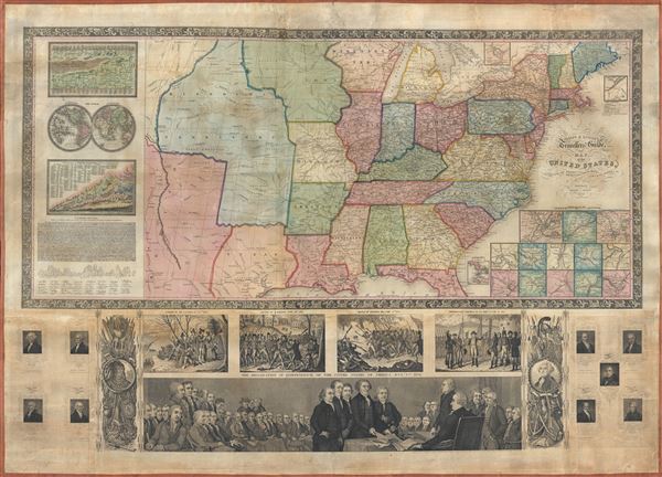
1841 Phelps and Ensign Wall Map of the United States
1841 (dated) $4,000.00
1841 Phelps and Ensign Wall Map of the United States
UnitedStatesWall-phelpsensign-1841$2,000.00

Title
Phelps and Ensign's travellers' guide, and map of the United States, containing the roads, distances, steam boat and canal routes etc.
1841 (dated) 27 x 41 in (68.58 x 104.14 cm) 1 : 4750000
1841 (dated) 27 x 41 in (68.58 x 104.14 cm) 1 : 4750000
Description
A very patriotic piece, this spectacular 1841 decorative wall map of the United States was prepared New York firm of Phelps and Ensign. The highly appealing production covers the United States from the Rocky Mountains to the Atlantic Seaboard and from Green Bay and the Straits of Michilimackinac to the Gulf of Mexico. This map was issued during the Republic of Texas period and Texas is thus illustrated with its pre-statehood boundaries. This map also predates the Mexican - American war, so Mexico occupies all lands west of Texas and the Missouri Territory. Roadways and mileage are often noted.
Thirteen insets detailing major ports appear in the lower right quadrant of the map proper. To the left of the main map are statistical tables illustrating the world's great rivers, the world in hemispheres, comparative mountain heights. There is also a key to the large illustration below. All of the signatories of the Declaration of Independence are accounted for with their signatures reproduced. The working of the Declaration itself is also reproduced.
The highlights of this map are the elaborate engravings that illustrate the lower quadrants. These include historical images of the pilgrims landing in 1620, the 1775 Battle of Lexington, the Battle of Bunker Hill, and Washington's 1783 farewell to the army. The largest illustration, filling the bottom of the map, depicts Thomas Jefferson, Benjamin Franklin, and other signing the Declaration of Independence on July 4, 1776. To either side of this image, culturally themed martial illustrations depict George Washington (right) and King Philip (left), an American Indian Sachem also known as Pometacom who lead an Indian uprising against English Colonists in 1676. Further illustrations include portraits of the nine American presidents up to William H. Harrison. Harrison was elected president in 1840 but died in April of 1841, just one month after taking office - marking this map as an exceptionally ephemeral production.
Phelps and Ensign first issued a map of this title in 1839 and terminated at the Mississippi. The present example, presaging the Mexican American War and Texas Annexation, is dramatically expanded to include the Rocky Mountains and additional illustrations. Various were issued in 1840 and, as above 1841. This map is a steel plate engraving prepared for Phelps and Ensign by J. Wells of Brooklyn, then not yep incorporated into New York City.
CartographerS
Humphrey Phelps (1799 - 1875) was an American map, broadside, and book publisher based in New York City. Phelps was born in 1799 in Hebron, Connecticut. Phelps' earliest work seems to be a plan of New York City for his Stranger's Guide, dating to about 1830. Between 183- and 1837 he published with Bela Scovil Squire (1786 - 1861) under the imprint of Phelps and Squire. The New York map publishing circle seems to have been quite close and Phelps commonly partnered with various other New York publishers and printers including Edward H. Ensign (1818 - 1871), Horace Thayer, Erastus Clark Bridgman (1817 - 1870), Thomas C. Fanning (1805 - 1873), Hooker, Peabody, Charles Magnus, Gaylord Watson, and George Walker, among others. The natural consequence of his rampant partnering is a vast and varied corpus of work including many scarce items with low print runs. Phelps is best known for his emigrant and tourist guides. More by this mapmaker...
Edward Hooker Ensign (August 18, 1818 - July 10, 1871) was an American map and print publisher based in New York during the middle part of the 19th century. Edward was born in West Hartland, Connecticut. Little is known of Ensign's training but he may have inherited his business from his father, Timothy Ensign (1795 - 1859), who was a map publisher active in New York. Ensign seems to have had a flair for partnerships and variously published with Humphrey Phelps (1799 - 1875), Horace Thayer, Thomas C. Fanning (1805 - 1873) and Erastus C. Bridgman (1817 - 1870), among others. His various imprints include 'Phelps and Ensign' (1841-1844), 'T. and E. H. Ensign' (1844-1848), 'Ensign and Thayer' (1849), 'Ensign, Thayer, and Company' (1850-1851), 'Horace Thayer and Company' (1852), and 'Ensign, Bridgman and Fanning' (1854-1863). It appears that father and son worked together for some time as well, publishing as either 'T. and E. H. Ensign' or 'Ensigns'. At least some of these companies maintained offices in both Buffalo and New York City. Learn More...
Condition
Very good. Professionally restored and backed on fresh linen. Missing original rollers. New rollers can be manufactured upon request.
References
Boston Public Library, Leventhal Center, G3700 1840 .P5. New York Public Library, Map Div. 01-5146. OCLC : 47017064.