This item has been sold, but you can get on the Waitlist to be notified if another example becomes available.
1962 Alumni Association Pictorial Historical Map of the University of North Carolina
UniversityNorthCarolina-alumniass-1962$475.00

Title
University of North Carolina at Chapel Hill.
1962 (undated) 26.5 x 20.75 in (67.31 x 52.705 cm)
1962 (undated) 26.5 x 20.75 in (67.31 x 52.705 cm)
Description
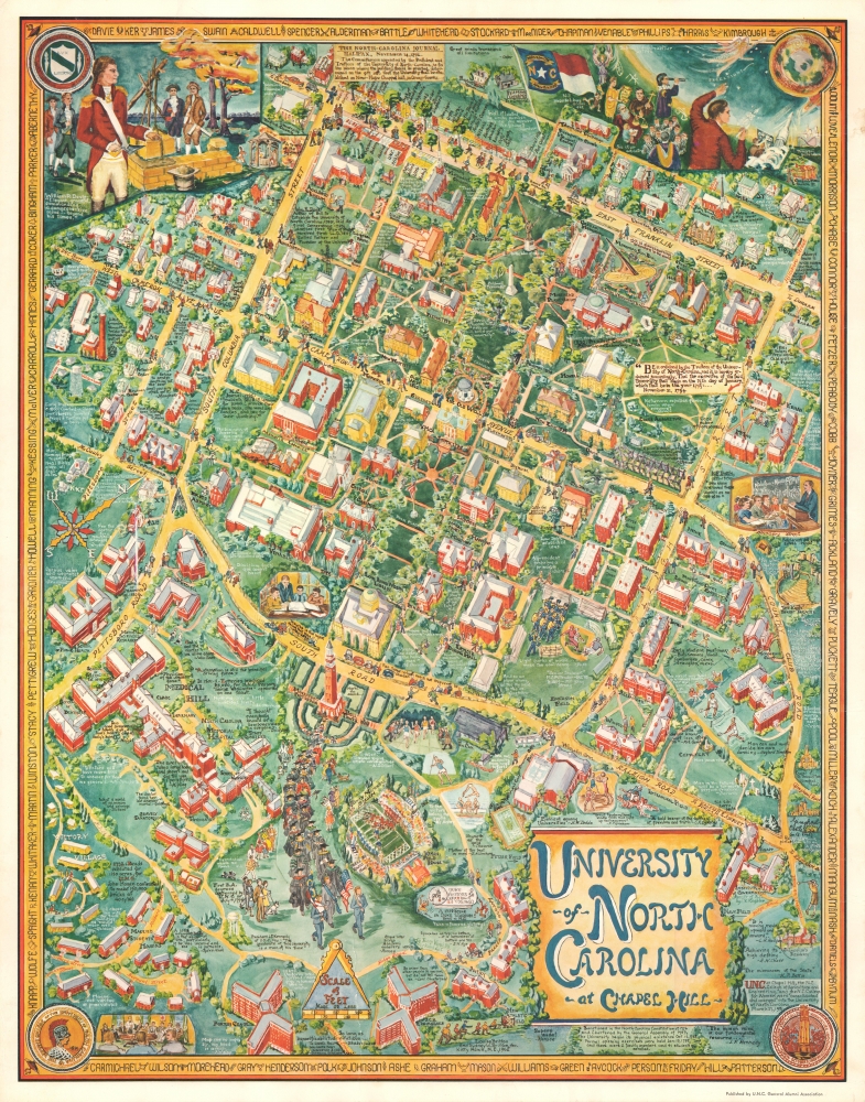
This is a 1962 historical pictorial view of the campus of the University of North Carolina Chapel Hill, produced by Sydney W. Britton and Louise Britton for the university's alumni association.
At top-left is an illustration of William Richardson Davie (1756 - 1820), a Founding Father and prominent member of the North Carolina General Assembly, considered to be the father of the university. At top-right are illustrations relating to astronomy, a reference to the university's importance for that field of study, particularly the Morehead Planetarium (constructed 1949), which was used to train NASA astronauts in celestial navigation. At bottom-left and bottom-right are the seals of the Women's College of the University of North Carolina (now UNC Greensboro) and the North Carolina State College of Agriculture and Engineering, which in 1931 merged into UNC-Chapel Hill. The border consists of the names of various campus buildings.
A Closer Look
Oriented towards the northwest, this richly-illustrated view contains a wide range of references to the history of the university from its earliest days to the modern era. These include buildings ranging from Old East (1793) to recent structures such as the Ehringhaus Residence Hall (1962). Other buildings throughout the campus are illustrated, often with the year of construction noted, along with relevant historical facts or quotes. In the spaces between buildings, additional facts and illustrations about the university and quotes from authors, artists, and philosophers appear. One particularly amusing reference near Kenan Memorial Stadium is a dig at rival Duke University, referencing a 1959 football game.At top-left is an illustration of William Richardson Davie (1756 - 1820), a Founding Father and prominent member of the North Carolina General Assembly, considered to be the father of the university. At top-right are illustrations relating to astronomy, a reference to the university's importance for that field of study, particularly the Morehead Planetarium (constructed 1949), which was used to train NASA astronauts in celestial navigation. At bottom-left and bottom-right are the seals of the Women's College of the University of North Carolina (now UNC Greensboro) and the North Carolina State College of Agriculture and Engineering, which in 1931 merged into UNC-Chapel Hill. The border consists of the names of various campus buildings.
Publication History and Census
This view was prepared by Louise Britton and Dr. Sydney W. Britton in 1962, as noted at bottom. According to records, a wall map edition was printed in a run of 500 copies on '150-pound Vellum Finish Bristol' board - of this, we have found no surviving examples. At the same time, an unspecified number of smaller lithographs, of which this is an example, were also printed 'by one of the country's leading lithographers' (unnamed) and sold by the General Alumni Association. The map is rare, with the University of North Carolina at Chapel Hill itself being the only institution noting it among their collections.Cartographer
Sydney William Britton (February 24, 1892 - 19??) was a British doctor. Born in England, Britton attended McGill University in Quebec from which he received a Bachelor of Science degree in 1922 and an M.D. in 1924. He soon embarked on his medical career accepting positions at Harvard, McGill, Johnson Hopkins, and finally as a Professor of Physiology at the University of Virginia. He was awarded a Fellowship by the John Simon Guggenheim Memorial Foundation in 1937. Britton married Louise Esther Weibel in 1924 and the couple had four children: two sons and two daughters. Having taught at the University of Virginia for twenty-four years years, Dr. and Mrs. Britton relocated to Nigeria, where Dr. Britton served as a Fulbright professor in the University of West Africa. Upon retiring and returning to the U.S., the couple devoted months of research and preparation towards a historical cartograph or pictorial map of the campus of the University of Virginia, printed in 1960. Afterwards, they produced a similar map of the campus of the University of North Carolina, published in 1962, which like the University of Virginia map was printed in a small run and marketed to alumni through alumni publications. More by this mapmaker...
Condition
Good. Some surface scuffing where it may once have been folding. Minor margin stains.
References
OCLC 949903916. The University of North Carolina Chapel Hill Alumni Review, Vol. LI, No.5, February 1963.