1846 Bradford Map of Washington, D.C., Cincinnati, Louisville, and New Orleans
USCities-bradford-1846$200.00

Title
Washington, Louisville and Jeffersonville, New Orleans, Cincinnati.
1846 (dated) 11.5 x 14.25 in (29.21 x 36.195 cm) 1 : 47520
1846 (dated) 11.5 x 14.25 in (29.21 x 36.195 cm) 1 : 47520
Description
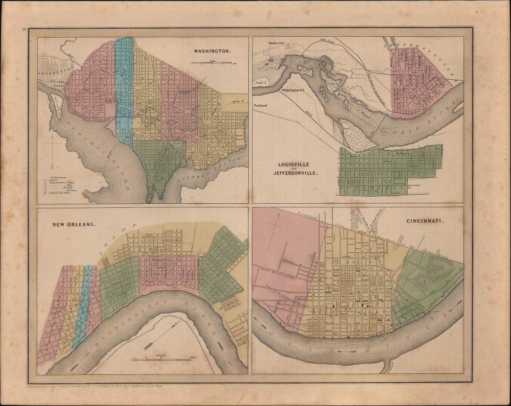
Four lovely city plans printed on one sheet- Washington, D.C., Louisville and Jeffersonville, New Orleans, and Cincinnati - published in 1846 in Thomas Bradford's Universal Illustrated Atlas.
The Washington D.C. map is notable for displaying the evolution of the city, including a canal running along the National Mall (the Washington City Canal), a problem-plagued effort that typified the financial and infrastructural problems of the city in the 19th century. The map also notes the location of government offices (Department of State, Department of War, etc.), demonstrating their close proximity to the White House at this time. At right, the 'Baltimore R.R.' (Baltimore and Ohio) is seen snaking into the city, though without the terminus at its station on New Jersey Ave. NW, near today's Union Station, which was completed in 1851. The bridge across the Potomac at left was known as the Long Bridge or Potomac Bridge, among other names, roughly consistent with today's 14th St. Bridges.
An important feature of the map of Louisville is the bridge from Louisville to Jeffersonville, which did not, in fact, exist. A bridge was proposed and planned from the late 1820s, with a cornerstone laid in 1836. However, the Panic of 1837 halted work on the bridge, along with many other public works in the young American Republic. A bridge was not constructed across the Ohio River until the late 1860s, opening in 1870 between Louisville and Clarksville.
Among other features, a curious element of the map of New Orleans is the inclusion of 'Fortifications of 1814' at bottom-right, referring to the Battle of New Orleans, which brought Andrew Jackson national fame. The map of Cincinnati displays a city undergoing rapid changes (it was among the fastest growing cities in the country in the second quarter of the 19th century), explaining the intermingling of geographic features and recent or expected urban development.
A Closer Look
Divided into four quadrants, the sheet includes city plans or maps of Washington, D.C., Louisville (with Jeffersonville, Indiana), New Orleans, and Cincinnati. All four maps are significant for demonstrating the development of American cities in the early-mid 19th century. They also emphasize the importance of major rivers (the Ohio, Mississippi, and Potomac), canals, and railroads in facilitating transportation and boosting economic growth. All the city plans use color shading to divide the cities into administrative subunits.The Washington D.C. map is notable for displaying the evolution of the city, including a canal running along the National Mall (the Washington City Canal), a problem-plagued effort that typified the financial and infrastructural problems of the city in the 19th century. The map also notes the location of government offices (Department of State, Department of War, etc.), demonstrating their close proximity to the White House at this time. At right, the 'Baltimore R.R.' (Baltimore and Ohio) is seen snaking into the city, though without the terminus at its station on New Jersey Ave. NW, near today's Union Station, which was completed in 1851. The bridge across the Potomac at left was known as the Long Bridge or Potomac Bridge, among other names, roughly consistent with today's 14th St. Bridges.
An important feature of the map of Louisville is the bridge from Louisville to Jeffersonville, which did not, in fact, exist. A bridge was proposed and planned from the late 1820s, with a cornerstone laid in 1836. However, the Panic of 1837 halted work on the bridge, along with many other public works in the young American Republic. A bridge was not constructed across the Ohio River until the late 1860s, opening in 1870 between Louisville and Clarksville.
Among other features, a curious element of the map of New Orleans is the inclusion of 'Fortifications of 1814' at bottom-right, referring to the Battle of New Orleans, which brought Andrew Jackson national fame. The map of Cincinnati displays a city undergoing rapid changes (it was among the fastest growing cities in the country in the second quarter of the 19th century), explaining the intermingling of geographic features and recent or expected urban development.
Publication History and Census
Despite the date of the copyright at bottom-left, this map was published in the 1846 edition of Bradford and Goodrich's A Universal Illustrated Atlas.Cartographer
Thomas Gamaliel Bradford (1802 - 1887) was born in Boston, Massachusetts, where he worked as an assistant editor for the Encyclopedia Americana. Bradford's first major cartographic work was his revision and subsequent republishing of an important French geography by Adrian Balbi, Abrege de Geographie published in America as Atlas Designed to Illustrate the Abridgment of Universal Geography, Modern and Ancient. Afterwards Bradford revised and expanded this work into his own important contributions to American cartography, the 1838 An Illustrated Atlas Geographical, Statistical and Historical of the United States and Adjacent Countries. Bradford's cartographic work is significant as among the first to record Texas as an independent nation. In his long career as a map publisher Bradford worked with William Davis Ticknor of Boston, Freeman Hunt of New York, Charles De Silver of Philadelphia, John Hinton, George Washington Boynton, and others. We have been able to discover little of Bradford's personal life. More by this mapmaker...
Source
Bradford, T. G. and Goodrich, S. G., A Universal Illustrated Atlas, exhibiting a Geographical, Statistical, and Historical view of the World, (Boston: Charles D. Strong) 1846.
The Universal Illustrated Atlas is one of the great American atlases of the first half of the 19th century. The atlas was first published in 1838 under the imprint of Charles D. Strong. It replaced and superseded Bradford's earlier smaller format Illustrated Atlas, Geographical, Statistical, and Historical, of the United States and the Adjacent Countries. Numerous reissues of the Universal Illustrated Atlas followed until about 1848. Although there are minor variations between the editions, most contain about 50 maps, the majority of which focus on the United States. Bradford's atlases are significant for recording North America during the Republic of Texas Era. In later editions, particularly the 1846 edition, Bradford illustrates the boom in railroad construction, possibly with the idea that his maps would aid travelers in planning journeys by rail. It was compiled by Thomas Gamaliel Bradford and Samuel Griswold Goodrich with most of the plates engraved by George Washington Boynton (fl. c. 1830 - 1850). Other contributors include Thomas Gordon (1778 - 1848), Fielding Lucas Jr. (1781 - 1854), Samuel Edward Stiles (1844 - 1901), Sherman and Smith (fl. c. 1829 - 1855), and Horace Thayer (1811 - c. 1874).
Condition
Good. Light foxing and soiling.
References
Rumsey 4453.007 (1841 edition).