1960 International Parks Highway Assoc. Pictorial Map of U.S. Highway 385 and 85
USHwy38585-anthony-1960$300.00

Title
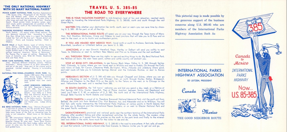
Canada to Mexico International Parks Highway Now... U.S. 85-385.
1960 (undated) 17.25 x 8 in (43.815 x 20.32 cm)
1960 (undated) 17.25 x 8 in (43.815 x 20.32 cm)
Description
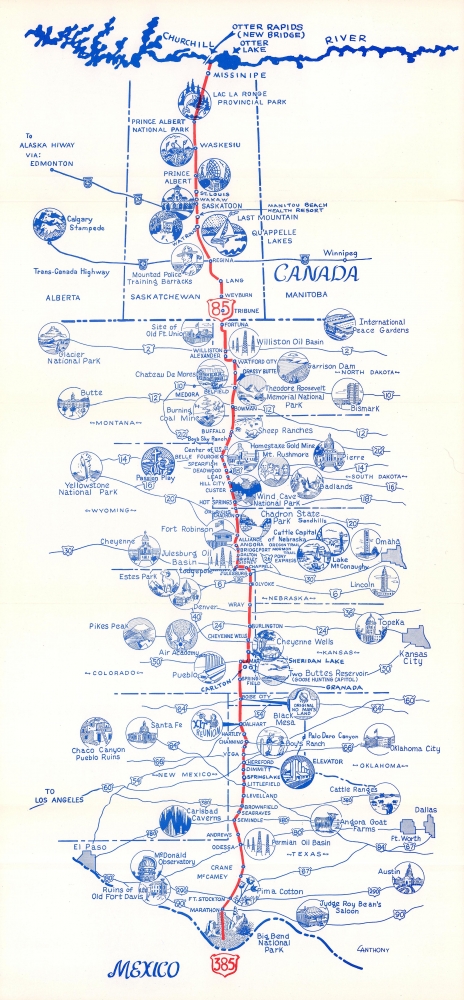
This is a c. 1960 International Parks Highway promotional pictorial map highlighting U.S. Highway 85 and 385, which ran north-south from Canada to Mexico. Circular vignettes promote national parks and other important or interesting sites along the route.
A Closer Look
Highlighting U.S. Highways 85 and 385 from the U.S.-Canada border to the U.S.-Mexico Border (with an extension north to Missinipe, Saskatchewan, Canada), vignettes highlight national parks, other important sites, cities, and towns. Previously known as the International Parks Highway (now called the CanAm Highway), the national parks along the route include Prince Albert National Park in Saskatchewan, Theodore Roosevelt Memorial National Park in North Dakota, Wind Cave National Park in South Dakota, and Big Bend National Park in Texas. Cities and towns along the route are identified and connecting highways are labeled using the U.S. highway shield. National parks labeled here but are not on either route include Glacier National Park, Yellowstone National Park, and Carlsbad Caverns. Bismark, Pierre, Butte, Cheyenne, Omaha, Lincoln, Denver, Topeka, Pueblo, Santa Fe, Oklahoma City, and Austin are featured in vignettes.Dating the Map
While this map is undated, through our research we learned that the numbering for U.S. 385 has been used twice. The first route to bear the number U.S. 385 became part of U.S. 87 and the 385 designation was decommissioned. The current U.S. 385 was first designated as such in 1959. As far as we know, every location marked on the map predates 1959 (we believe the latest to be the U.S. Air Force Academy which was established in 1954) thus our date of c. 1960.The International Parks Highway Association
The International Parks Highway Association (1938 - 19xx) was an American highway association founded with the purpose of creating a north-south highway from Big Bend Park in Texas (which at the time had not yet been designated a national park) to the national parks of Canada. The association was founded in the Chisos Mountains of Texas when members of the Highway 51 Association voted to rename their organization the International Parks Highway Association because it was 'more impressive'.Highway Associations
The movement promoting the construction of 'good quality' roads did not begin with the invention of the automobile, but rather with the bicycle. At the time, most interurban roads were unpaved and impractical for cycling. The 'Good Roads Movement' was inaugurated in May 1880 to advocate for bicycle enthusiasts, riding clubs, and manufacturers. By 1910, the American Automobile Association (AAA) jumped onboard, along with over one hundred other local and national organizations. 'Road booster' organizations emerged to promote specific, often branded, highways. By the 1920s, about 250 'named' highways, each with their own boosters, crossed the United States. 'Road boosters' still exist, but most disbanded in the 1950s and 60s with the emergence federally funded Interstate Highway System.Publication History and Census
This map was drawn by an artist known only as Anthony and published by the International Parks Highway Association c. 1960. We note a single cataloged example which is part of the collection of the State Historical Society of North Dakota State Archives.Condition
Very good. Light wear and toning along original fold lines.
References
OCLC 953621739.