1892 Rand McNally Map of the United States showing Density of Population
USPopDensity-randmcnally-1893$90.00

Title
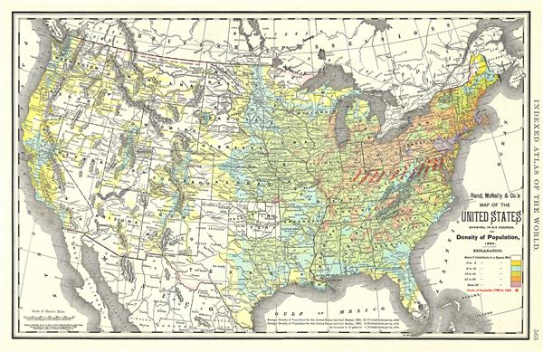
Map of the United States showing, in six degrees, the Density of Population, 1890.
1892 (dated) 13 x 20 in (33.02 x 50.8 cm) 1 : 10100000
1892 (dated) 13 x 20 in (33.02 x 50.8 cm) 1 : 10100000
Description
This is a lovely 1892 Rand McNally and Company map of the United States, showing the density of its population in 1890. Divided by color coding into six degrees ranging from below two inhabitants to a square mile – above 90 inhabitants to a square mile, this map also marks the various centers of population from 1790 to 1890 with red stars. Throughout rivers, towns, cities, mountains, railroads, and other topographical features are noted with elevation rendered by hachures. This map was issued as plate no. 565 in the 1893 edition of Rand McNally and Company's Indexed Atlas of the World- possibly the finest atlas Rand McNally ever issued.
Cartographer
Rand, McNally and Co. (fl. 1856 - present) is an American publisher of maps, atlases and globes. The company was founded in 1856 when William H. Rand, a native of Quincy, Massachusetts, opened a print shop in Chicago. Rand hired the recent Irish immigrant Andrew McNally to assist in the shop giving him a wage of 9 USD per week. The duo landed several important contracts, including the Tribune's (later renamed the Chicago Tribune) printing operation. In 1872, Rand McNally produced its first map, a railroad guide, using a new cost effective printing technique known as wax process engraving. As Chicago developed as a railway hub, the Rand firm, now incorporated as Rand McNally, began producing a wide array of railroad maps and guides. Over time, the firm expanded into atlases, globes, educational material, and general literature. By embracing the wax engraving process, Rand McNally was able to dominate the map and atlas market, pushing more traditional American lithographic publishers like Colton, Johnson, and Mitchell out of business. Eventually Rand McNally opened an annex office in New York City headed by Caleb S. Hammond, whose name is today synonymous with maps and atlases, and who later started his own map company, C. S. Hammond & Co. Both firms remain in business. More by this mapmaker...
Source
Rand McNally & Co., Rand, McNally & Co's Indexed Atlas of the World, (Chicago) 1893.
Condition
Very good. Chart on verso.
References
Rumsey 3565.065 (1897 edition). Philips (atlases) 1026 (1898 edition).