This item has been sold, but you can get on the Waitlist to be notified if another example becomes available, or purchase a digital scan.
1949 De Grange Pictorial Map of the United States Products and Industries
USProductsIndustries-degrange-1949$150.00


Title
The United States Products and Industries.
1949 (dated) 26.75 x 34.5 in (67.945 x 87.63 cm) 1 : 5400000
1949 (dated) 26.75 x 34.5 in (67.945 x 87.63 cm) 1 : 5400000
Description
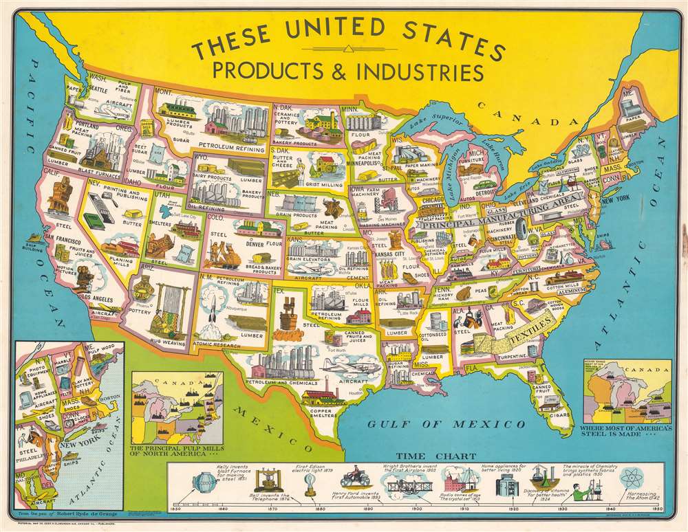
This is a 1949 Robert Hyde de Grange pictorial map of the United States illustrating the post-WWII economic boom.
A Closer Look
Pictorial vignettes throughout highlight industries by state. Steel production, paper mills, petroleum and oil refining, and bakery products are part of the economy in several states. Aircraft production (a relatively new product) occurs in Texas, Kansas, California, Washington, Maryland, and New York. Atomic Research, another cutting-edge industry, appears in New Mexico. An inset in the lower-left focuses on New England, allowing for a more detailed view of the dense region. A second inset in the lower-left marks the principal pulp mills in North America, with several mills illustrated in Canada. A third inset, situated in the lower-right, identifies most of the steel mills in the United States. A timeline that occupies most of the bottom border tracks the progress of American technological innovation from the Kelly blast furnace through Edison's light bulb and Ford's automobile to 'harnessing the atom'.The Post-War Economic Boom
Following World War II (1939 - 1945), the United States experienced an economic boom until the early 1970s. Private industry quickly and successfully pivoted from wartime production to peacetime production, changing from producing airplane parts and ammunition to appliances, automobiles, clothing, and even houses. The GI Bill financed the development of a well-educated workforce and the Federal Housing Administration made it possible for returning veterans to buy property. Americans who spent the war years saving their discretionary income, and now were hungry to spend and American industry answered.Publication History and Census
This map was drawn by Robert Hyde de Grange and published by the Pictorial Map Company in 1949. We note five examples cataloged in OCLC which are part of the collections at the Library of Congress, the Buffalo and Erie County Public Library, the University of Michigan, the University of Chicago, and Southern Illinois University.Condition
Good. Light foxing. Even overall toning. Closed tear along Ohio / West Virginia border.
References
OCLC 36974519.