
1949 De Grange Pictorial Map of the United States and its Resources

This item has been sold.
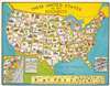
These United States and Their Resources.
Resources throughout the United States.
Choose a Collection:
- Digital Map Information
- Suitable for large format printing
- File Size: 189.96 MB
- File Type: ZIP / TIFF
- ICC color profile embedded
- Delivered instantly via download link
This Item
Enquire
Resources throughout the United States.
This is a 1949 Robert Hyde de Grange pictorial map of the United States and its resources. The map is part of a series prepared by de Grange to highlight the post-WWII economic boom - in its various aspects.A Closer Look
Pictorial icons indicate resources present from coast to coast varying from mineral deposits to crops and livestock. Each icon is labeled, and every state is identified. Numerous minerals are referenced across the country, both with icons and by text. Among these are salt, limestone, gold, platinum, radium, and uranium. Apples, grapes, potatoes, corn, and wheat are only a few of the crops pictured. Cattle, sheep, and poultry are illustrated as well.The Post-War Economic Boom
Following World War II (1939 - 1945), the United States experienced an economic boom until the early 1970s. Private industry quickly and successfully pivoted from wartime production to peacetime production, changing from producing airplane parts and ammunition to appliances, automobiles, clothing, and even houses. The GI Bill financed the development of a well-educated workforce and the Federal Housing Administration made it possible for returning veterans to buy property. Americans who spent the war years saving their discretionary income, and now were hungry to spend and American industry answered.<Publication History and Census
This map was created by Richard Hyde de Grange and published by the Pictorial Map Company in 1949. We note three cataloged examples in OCLC which are part of the collections at the Library of Congress, the Buffalo and Erie County Public Library, and Southern Illinois University.Condition
Good. Light foxing. Even overall toning. Closed margin tears professionally repaired on verso. Light scuffing to second 'E' in 'Resources' in title.
References
OCLC 36974479.