This item has been sold, but you can get on the Waitlist to be notified if another example becomes available, or purchase a digital scan.
1831 Dower / Teesdale Map of Prussia, Northern Germany
Prussia-dower-1831$100.00

Title
Prussia.
1831 (dated) 13 x 16 in (33.02 x 40.64 cm) 1 : 3000000
1831 (dated) 13 x 16 in (33.02 x 40.64 cm) 1 : 3000000
Description
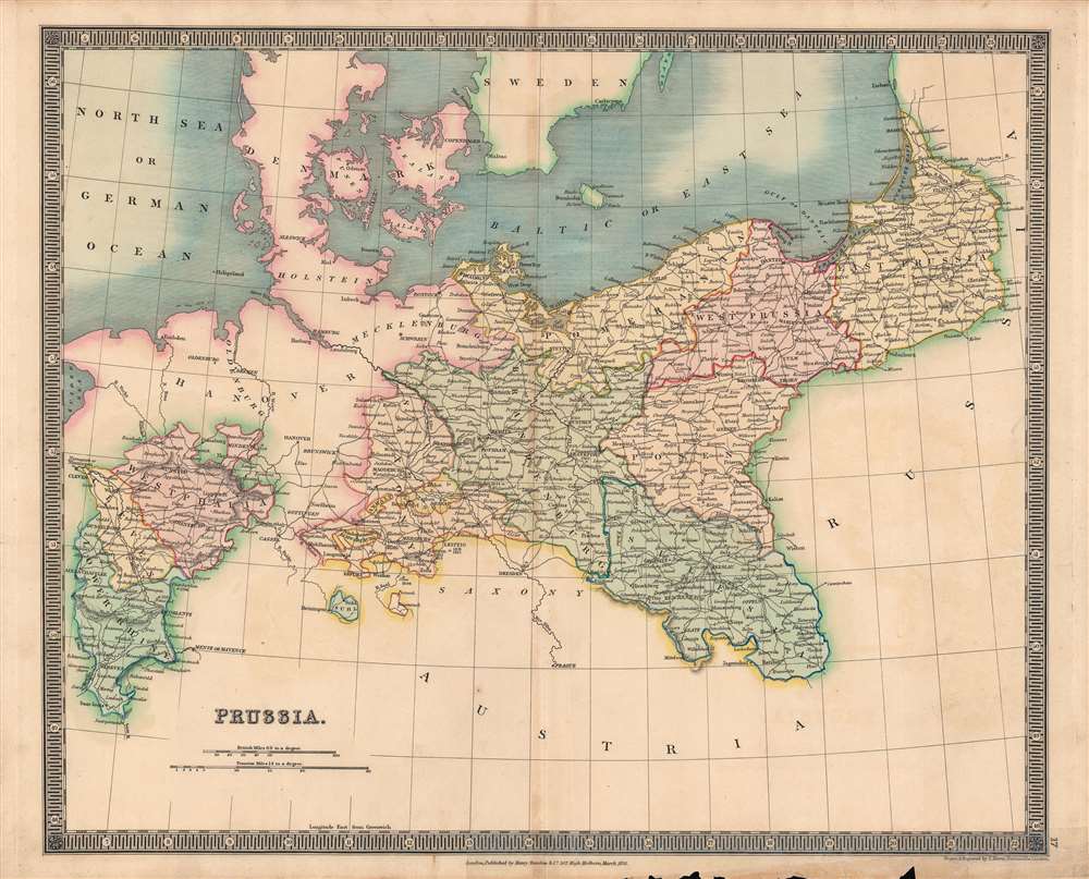
This is a fine example of Henry Teesdale and John Dower's 1831 map of Prussia published in their A New General Atlas of the World. It depicts the Kingdom of Prussia as it emerged from the Napoleonic Wars and the Congress of Vienna, larger and more powerful than before, poised to challenge Austria for preeminence in the German lands.
The Congress of Vienna replaced the Holy Roman Empire with the German Confederation, with Prussia and Austria as the two major powers in the confederation. Prussia was substantially enlarged by the territorial divisions at the Congress of Vienna, and dominated northern Germany politically, economically, and in population. Liberals looked to Berlin as a beacon of enlightened government and forward-thinking reforms, in contrast to the more rigid monarchies of Austria and other states. Prussia also expanded its influence through the Zollverein, a customs union among German states that did not include Austria. In the 1840s - 1870s, Prussia engaged in war several times, taking Schleswig (here as Sleswick) and Holstein before conquering or absorbing territories to the south in wars with Austria and France, resulting in the formal creation of a unified, Prussian-led German Empire in 1871.
A Closer Look
This map covers much of the northern part of the German lands, from Aix-la-Chapelle (that is, Aachen) to Konigsberg (Kaliningrad), hinting at the future scope and ambitions of the Prussian state. Roads, rivers, cities, towns, and elevations are indicated. Scales are given in both British and Prussian miles, while colors are used to greatly simplify and distinguish the constituent states (duchies, principalities) of Prussia. Both exclaves and enclaves are present, a remnant of the maddeningly complex territorial divisions of the Holy Roman Empire that persisted into the 19th century.Prussia's Rise and the Unification of Germany
Beginning in the late 17th century, Prussia was transformed from a disparate confederation of feudal lords into an absolute monarchy with one of Europe's most powerful militaries, initially far out of proportion to the territory's size and wealth. A string of effective rulers in the 18th century allowed Prussia to not only survive the constant wars of the era (the dates and locations of battles are indicated here) but to establish itself as an enlightened haven for the arts, science, and philosophy. Prussia struggled to navigate the shifting alliances of the Napoleonic Wars but emerged from the conflict as a victorious power (Prussian troops played a decisive role at the Battle of Waterloo).The Congress of Vienna replaced the Holy Roman Empire with the German Confederation, with Prussia and Austria as the two major powers in the confederation. Prussia was substantially enlarged by the territorial divisions at the Congress of Vienna, and dominated northern Germany politically, economically, and in population. Liberals looked to Berlin as a beacon of enlightened government and forward-thinking reforms, in contrast to the more rigid monarchies of Austria and other states. Prussia also expanded its influence through the Zollverein, a customs union among German states that did not include Austria. In the 1840s - 1870s, Prussia engaged in war several times, taking Schleswig (here as Sleswick) and Holstein before conquering or absorbing territories to the south in wars with Austria and France, resulting in the formal creation of a unified, Prussian-led German Empire in 1871.
Publication History and Census
This map was engraved by John Dower for the 1831 edition of A New General Atlas of the World, published by Henry Teesdale. This appears to be an especially rare example of this map, as other Dower maps dated to or near 1831 are titled 'Prussia, with part of Poland' (editions from soon afterwards also include an inset map of Berlin at top-left). The cataloged map most closely resembling the present example is the 1832 edition of Dower's Prussia map, published in W.M. Higgins' A General Descriptive Atlas of The Earth, which is part of the David Rumsey Map Collection (List No. 0247.048). The present edition is not known to be held by any institution and has no known history on the market.CartographerS
John James Dower (June 1, 1825 - 1901) was a well-respected mapmaker, print seller, and publisher based in London, England. Dower is the heir to the more prominent London engraver and mapmaker John Crane Dower (1791 - 1847). Dower worked with many prominent middle to late 19th century London map publishers including Weller, Cassell, Bacon, Petermann, and others. He was elected to the Royal Geographical Society in 1854. Dower also published on maps his own account including one atlas and various school geographies. In addition to his cartographic work, Dower is well known as an engraver of military scenes. More by this mapmaker...
Henry Teesdale (December 1776 - January 1856) was a British map publisher active in the first half of the 19th century. Teesdale was born in London. He was elected to the Royal Geographical Society in 1830. Teesdale initially partnered with John Hordan and William Colling Hobson as Henry Teesdale and Company, but this partnership was dissolved in 1832. Afterwards Teesdale continued to publish maps and atlases on his own account. He worked with several major British map engravers of the period including John Crane Dower, Christopher Greenwood, and Josiah Henshall, among others. His most prominent work is a large map of the world engraved by Dower. He must have enjoyed considerable commercial success because in 1845 he is registered as a partner in the Royal Bank of Scotland. Teesdale died in January of 1856 and was buried in All Souls, Kensal Green. Learn More...
Source
Dower, John, A New General Atlas of the World, (London: Teesdale) 1831.
Condition
Good. Some discoloration along central fold line, especially towards bottom margin. Wear and some loss along bottom edge.