1966 Island Workshop Pictorial Map of the U.S. Virgin Islands
USVirginIslands-islandworkshop-1966$350.00

Title
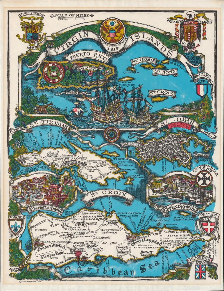
Virgin Islands United States 1917.
1966 (dated) 19.75 x 15.5 in (50.165 x 39.37 cm) 1 : 100000
1966 (dated) 19.75 x 15.5 in (50.165 x 39.37 cm) 1 : 100000
Description
A colorful pictorial map of the U.S. Virgin Islands, prepared and published in 1966 by Island Workshop. The map abounds with historical references to the islands' colonial past, when, at various points, they were divided between the empires of multiple European nations and entities.
A Closer Look
The top third of the sheet includes a general map of the region, including Puerto Rico. The seal of the United States with the date of the islands' acquisition (1917) appears at top center, while the coats of arms of Christopher Columbus and the Spanish monarchy appear at top-left and right, respectively. Ships in the foreground are labeled 'Ponce' for Ponce de Leon, while a smaller ship nearby might be a reference to the smaller ships of Columbus' voyages. Below, the islands of St. Thomas, St. Croix, and St. John are illustrated, with insets of the cities of Charlotte, Amalie, and Christiansted. Other towns are labeled on the map and, in some cases, illustrated, along with airports and other features, such as a pier and racetrack on St. Croix. Bays, cays, and smaller islands are marked all along the islands' coasts. Illustrations of lush vegetation and the coats of arms of the various colonial empires that controlled one or more of the islands at various points interweave and surround the map.Danish America
Like many Caribbean islands, the U.S. Virgin Islands islands passed through a series of European colonial empires in the early modern period. Following Christopher Columbus and the Spanish, the French, English, Dutch, and even the Knights of Malta each claimed part of the archipelago at one point, leaving a permanent mark on the islands, in their placenames, if nothing else. Between the late 17th and early 18th century, the Danish gained control of St. Thomas and St. John and purchased St. Croix from France. In the mid-19th century, following several slave revolts and amid the broader emancipation movement, slavery was abolished, though strict labor laws remained. By the late 1860s, the potential sale of the islands to the United States appeared to be a neat solution for both countries. It took fifty years for agreements to be reached and approved by the Danish Parliament; ultimately, the threat of the islands being utilized by Germany during World War I (1914 - 1918) finalized the 1917 sale. Since joining the United States, especially since World War II (1939 - 1945), the islands have experienced a tourism boom, the basis for a robust local economy.Publication History and Census
This map was published by Island Workshop in 1966. Island Workshop was presumably a local outfit, but we have been unable to find any additional information on them. The only known institutional holding of the map is with the Cincinnati and Hamilton County Public Library.Condition
Good. Several small tears professionally repaired. Uneven toning in margin, likely from earlier framing. Some surface abrasion at right and bottom.
References
OCLC 143608578.