
1907 Oglesby Large Wall Map of Utah

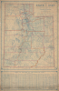
Map of the State of Utah.
Mormons, Mining, and Modernization.
$2,400.00
Choose a Collection:
- Digital Map Information
- Suitable for large format printing
- File Size: 111.5 MB
- File Type: ZIP / TIFF
- ICC color profile embedded
- Delivered instantly via download link
This Item
Enquire
Mormons, Mining, and Modernization.
This is a rare, large-format (5' by 3') 1907 wall map of Utah prepared by Oglesby and Oglesby. It captures the state in the years immediately after joining the Union, thus recording face-paced changes brought about by railroads and a population explosion.A Closer Look
The map covers the state of Utah in detail, highlighted by hand-coloring tracing the boundaries of counties, judicial districts, mining districts, and forest, military, and Indian reservations. Cities, towns, villages, townships, and surveyors' offices are noted throughout, while wagon roads, railroads (existing and proposed), canals, and pipelines are traced. Several tables and legends at the bottom provide additional information, including explanations of abbreviations used across the map, a list of counties with their area and population, an extended index of cities and towns with their coordinates according to a grid surrounding the map, and similar indexes for forest reserves, lakes, mining districts, mountains, and valleys.Historical Context
The turn of the 20th century was a transformative era for Utah, marking its transition from a remote, isolated frontier into an integrated part of the American Union. After decades of political and religious friction, Utah finally achieved statehood on January 4, 1896, after constitutionally outlawing polygamy. As the 20th century dawned, the pioneer era began to give way to a modern civic identity, with Salt Lake City evolving from a desert outpost into a sophisticated urban center with paved streets, electric lights, and a burgeoning secular government. The expansion of railroads and the mining industry largely drove modernization. While the completion of the First Transcontinental Railroad in 1869 had broken the initial isolation, the early 20th century saw a web of spur lines connect copper, silver, and coal mines in the state's rugged interior to national markets. The state's population became increasingly diverse as thousands of immigrants from Greece, Italy, Japan, the Balkans, and other parts of the U.S. arrived to work in the mines and on the tracks, although not without friction, as racist anti-immigrant rhetoric and even violence were commonplace.Publication History and Census
This map was prepared and published by the firm Oglesby and Oglesby in Salt Lake City in 1907. It is very rare; the only other known example is held by Brigham Young University.Cartographer
Oglesby and Oglesby (fl. c. 1905 - 1909) was a map publisher based in Salt Lake City, Utah in the early 20th century. Very little information is available about the firm, which appears to only have been in existence for a few years. Only three works are known to have been published by the firm: two large wall maps of Utah (1907) and Idaho (1908), respectively, and an undated map of Salt Lake City. Utah State Auditor's Reports show several small payments to the firm between 1905 and 1909, likely for copies of their large Utah wall map. Further Details...
Condition
Average. Dampstaining. Toning. On original linen.
References
OCLC 367569536.