This item has been sold, but you can get on the Waitlist to be notified if another example becomes available, or purchase a digital scan.
1849 S.D.U.K. Map of Tasmania or Van Diemen's Land and Western Australia
VanDiemen-sduk-1849$75.00

Title
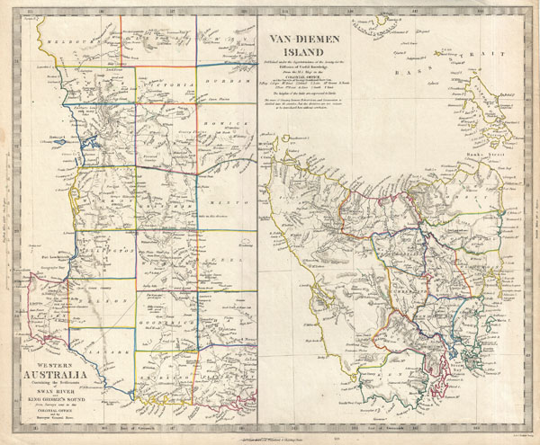
Van Diemen Island. Western Australia Containing the Settlements of Swan River and King George's Sound from Surveys sent to the Colonial Office.
1849 (undated) 13 x 15.5 in (33.02 x 39.37 cm)
1849 (undated) 13 x 15.5 in (33.02 x 39.37 cm)
Description
This is the c. 1849 Edward Stanford edition of the Society for the Diffusion of Useful Knowledge's historic map of Western Australia and Tasmania or Van Diemen's Land. Essentially two maps on one sheet. The leftmost map details western Australia from Melbourne south around Sussex to Stirling and Plantagenet. Notes numerous counties, roadways, geographical features, and more. The right hand map is a large detail of Van Diemen's Island or Tasmania. This map offers a significant update from previous editions in the addition of county detail to the Island. Names twelve counties as well as numerous geographical features, roadways, cities, and towns. Published by Edward Stanford of 6 Sharing Cross for the c. 1849 edition of the Maps of the S.D.U.K. atlas.
Cartographer
The "Society for the Diffusion of Useful Knowledge" (1826 - 1848) was a Whiggish organization founded in 1828 at the instigation of idealistic British lord Henry Peter Brougham. The admirable goal of the Society was to distribute useful information via a series of publications to the English working and middle classes. It promoted self-education and the egalitarian sharing of all knowledge. While closely tied to the London University and publishing houses on the order of Baldwin and Cradock, Chapman and Hall, and Charles Knight, the Society failed to achieve its many lofty goals in finally closed its doors in 1848. Most likely the failure of the Society resulted from its publications being too expensive for its intended lower to middle class markets and yet not large and fine enough to appeal to the aristocratic market. Nonetheless, it did manage to publish several extraordinary atlases of impressive detail and sophistication. Their most prominent atlas consisted of some 200 separately issued maps initially published by Baldwin and Cradock and sold by subscription from 1829 to 1844. Afterwards, the Society combined the maps into a single world atlas published under the Chapman and Hall imprint. In its day, this atlas was unprecedented in its quality, scope, and cost effectiveness. Today Society, or S.D.U.K. as it is commonly known, maps are among the most impressive examples of mid-19th century English mass market cartographic publishing available. The S.D.U.K. is especially known for its beautiful and accurately detailed city plans. More by this mapmaker...
Source
Maps of the Society for the Diffusion of Useful Knowledge. Vol. 1. London: Edward Stanford, 6 Sharing Cross, 1849.
Condition
Very good. Light overall toning. Blank on verso.
References
Rumsey 0890.157. Tooley, R.V., The mapping of Australia and Antarctica, 2 nd. ed., p. 147, no. 1176 and p. 343, no. 391.