This item has been sold, but you can get on the Waitlist to be notified if another example becomes available, or purchase a digital scan.
1851 Tallis and Rapkin Map of Van Diemen's Land or Tasmania
VanDiemensIsland-tallis-1851$100.00

Title
Van Diemen's Island or Tasmania.
1851 (undated) 14 x 10.5 in (35.56 x 26.67 cm) 1 : 1457280
1851 (undated) 14 x 10.5 in (35.56 x 26.67 cm) 1 : 1457280
Description
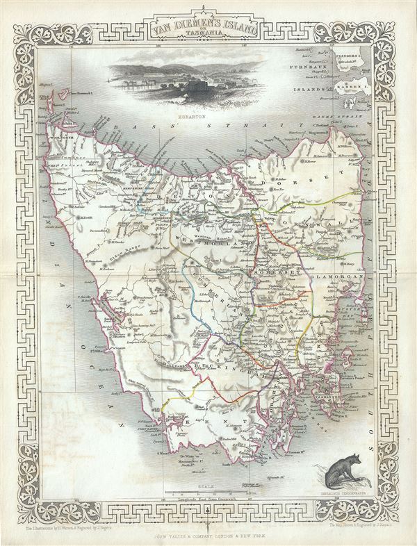
This is an impressive 1851 Tallis map of Van Diemen's Island or Tasmania. The map covers the entire island of Tasmania in considerable detail noting towns, lakes, mountain ranges and other topographical features. Van Diemen's Land was colonized by the British as a Penal Colony under the name 'Van Diemen's Land,' referring to the Dutch East India Company governor who sponsored Tasman's historic 1642 discovery of the island. In 1856, five years after this map was issued, Van Diemen's Land would be granted responsible self-government and renamed 'Tasmania.'
This map includes illustrations by H. Warren of Hobart Town, a Tasmania dog and the residence of the Van Diemen Land Company's Agent. The whole has the highly decorative presentation and elaborate border distinctive of Tallis maps. This map was issued as part of the 1851 edition of John Tallis and Company's The Illustrated Atlas, And Modern History of the World.
This map includes illustrations by H. Warren of Hobart Town, a Tasmania dog and the residence of the Van Diemen Land Company's Agent. The whole has the highly decorative presentation and elaborate border distinctive of Tallis maps. This map was issued as part of the 1851 edition of John Tallis and Company's The Illustrated Atlas, And Modern History of the World.
Cartographer
John Tallis and Company (1838 - 1851) published views, maps, and atlases in London from roughly 1838 to 1851. Their principal works, expanding upon the earlier maps of John Cary and Aaron Arrowsmith, include an 1838 collection of London Street Views and the 1849 Illustrated Atlas of the World. The firm’s primary engraver was John Rapkin, whose name and decorative vignettes appear on most Tallis maps. Due to the embellishments typical of Rapkin's work, many regard Tallis maps as the last bastion of English decorative cartography in the 19th century. Although most Tallis maps were originally issued uncolored, it was not uncommon for 19th century libraries to commission colorists to "complete" the atlas. The London Printing and Publishing Company of London and New York bought the rights for many Tallis maps in 1850 and continued issuing his Illustrated Atlas of the World until the mid-1850s. Specific Tallis maps later appeared in innumerable mid to late-19th century publications as illustrations and appendices. More by this mapmaker...
Source
Tallis, J. and F., The Illustrated Atlas, And Modern History Of The World Geographical, Political, Commercial & Statistical, 1851.
Condition
Very good. Minor wear along original centerfold. Minor spotting. Blank on verso.
References
Rumsey 0466.056. Phillips (Atlases) 804.