
This item below is out of stock, but another example (left) is available. To view the available item, click "Details."
Details
1858 H.F. Münster City Plan or Map of Venice, Italy
1858 (undated) $450.00
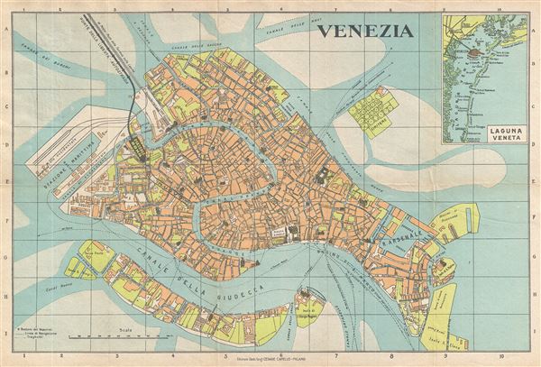
1950 Capello Pocket Map or Plan of the City of Venice, Italy
Vanezia-capello-1950$50.00

Title
Venezia.
1950 (undated) 10.5 x 17 in (26.67 x 43.18 cm) 1 : 12500
1950 (undated) 10.5 x 17 in (26.67 x 43.18 cm) 1 : 12500
Description
This is a beautiful c.1950 map or city plan of Venice, Italy by Cesare Capello. It covers Venice from Canale Scomenzera to Isola San Pierto and Bacini di Raddobbo and from Isola Della Giudecca to Canal Delle Sacche in the north. The map details streets, canals, parks, islands, transportation lines and a host of other topographical features. The island of Isola di San Michele is also included. An inset in the top right quadrant features the Venetian Lagoon. A 127 page 'artistic illustrated guide' accompanies the map. This includes a variety of useful tourist information, including details about museums, galleries, consulates, festivals, history of Venice, gondola and motor boat services, art in Venice, cultural, sporting and industrial activities and several itineraries for the traveler. The map and guide were published by Cesare Capello in c.1950.
Source
Capello, C., How to Visit Venice and its neighbourhoods An artistic illustrated guide, Milan.
Condition
Very good. Minor wear along original fold lines. Overall toning. Attached to original cover and accompanied by original booklet.