This item has been sold, but you can get on the Waitlist to be notified if another example becomes available.
1966 Stars and Stripes Map of Vietnam During the Vietnam War
Vietnam-starsandstripes-1966$187.50

Title
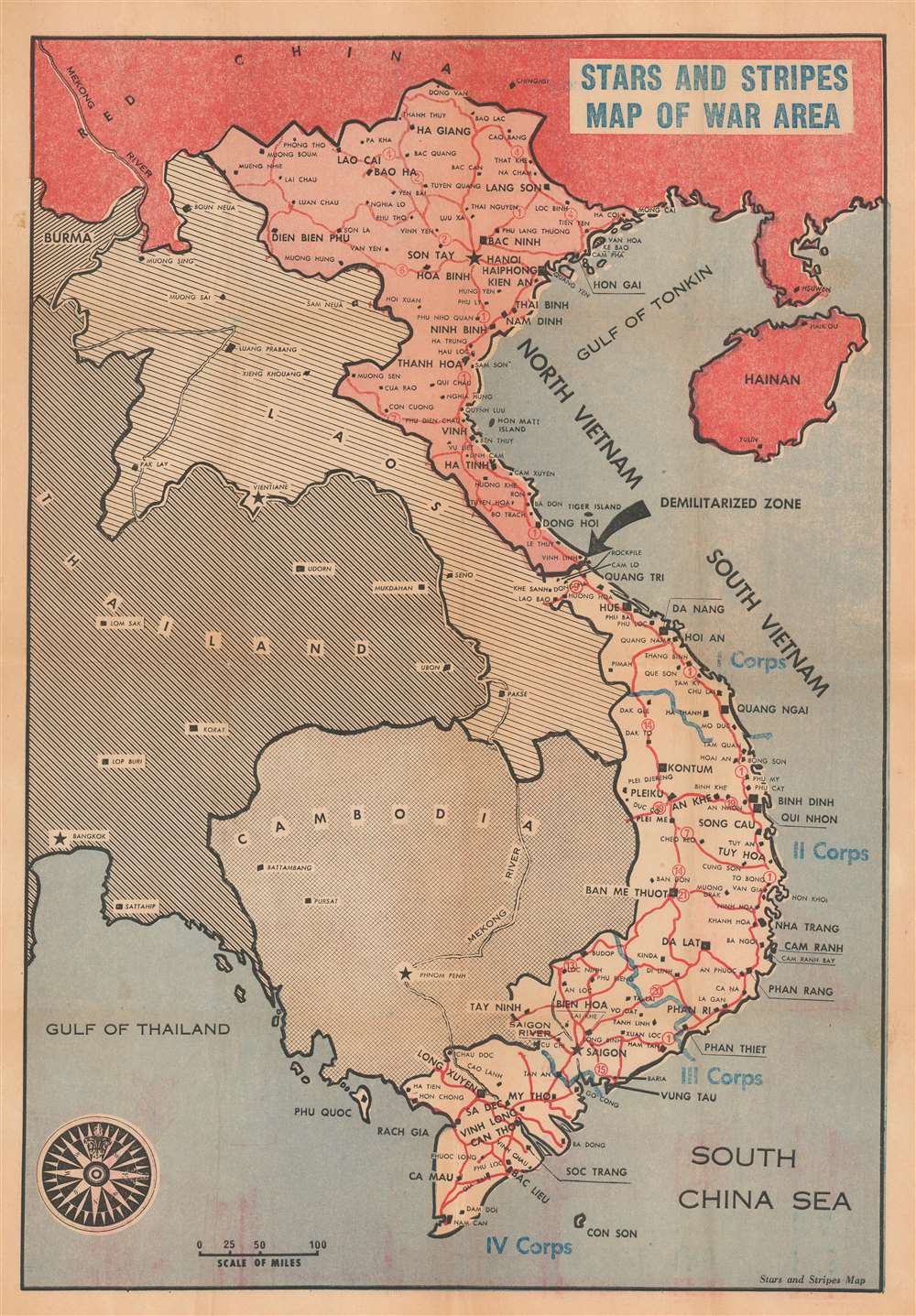
Stars and Stripes Map of War Area.
1966 (undated) 20.75 x 14.5 in (52.705 x 36.83 cm) 1 : 3400000
1966 (undated) 20.75 x 14.5 in (52.705 x 36.83 cm) 1 : 3400000
Description
This is a c. 1966 Stars and Stripes map of Vietnam during the Vietnam War. Vietnam is divided into North and South Vietnam, and a large black arrow emphasizes the intervening Demilitarized Zone. Cities, towns, and villages are labeled throughout, including Hanoi, Haiphong, Da Nang, and Saigon. Blue text and lines identify American military districts in South Vietnam. Laos, Thailand, and Cambodia are also included.
The Vietnam War
The Vietnam War, known in Vietnam as the 'Resistance War Against America' or simply the 'American War', raged between November 1, 1955, and April 30, 1975, when Saigon fell to the North Vietnamese. A complicated conflict with an even more complicated history and legacy, the Vietnam War pitted the communist supported North Vietnamese, led by Ho Chi Minh, against the American supported anti-communist South Vietnamese. American anti-communist dogma drove much of America's enthusiasm for involving themselves in Southeast Asia and their fear that 'if one country fell to Communism, then more would fall.' Eventually, as the conflict between the North and South grew fiercer, American involvement became more and more overt. Finally, American ground troops were sent into combat against the North Vietnamese and the Viet Cong. 1968, three years after the map was published, proved to be a pivotal year, with U.S. troop strength in Vietnam reaching its maximum of 549,500 soldiers. 1968 also saw the Tet Offensive, the most successful North Vietnamese attack on American forces, and a waning of American domestic support for the war. U.S. forces withdrew in January 1973, and Saigon fell to the North Vietnamese on April 30, 1975.Publication History and Census
This map was created and published by Stars and Stripes c. 1966. An example is part of the collection at the Library of Congress.Cartographer
Stars and Stripes (1861 - Present) is an American daily military newspaper. Founded in 1861 by Union soldiers from Illinois after setting up camp in Bloomfield, Missouri, this editorially independent publication has published newspapers for American soldiers ever since. Today it publishes for daily print editions for service members overseas, as well as seven digital editions. Stars and Stripes has had some famous contributors over is storied history. Harold Ross edited Stars and Stripes during World War I and after the war he founded The New Yorker. During World War II, Bill Mauldin published his popular 'Up Front' cartoons in Stars and Stripes, which in turn led to a successful career as an editorial cartoonist after the war. Ernie Pyle, a Pulitzer-Prize winning journalist, had his stories regularly published in Stars and Stripes before he was killed on Iejima during the Battle of Okinawa. More by this mapmaker...
Condition
Very good. Newsprint. Verso repairs to fold separations and at fold intersections. Closed martin tears professionally repaired on verso. Blank on verso.
References
Library of Congress G8021.S73 1966 .P3 VHP MS05.