This item has been sold, but you can get on the Waitlist to be notified if another example becomes available, or purchase a digital scan.
1929 Nostrand Birds Eye View Map of New York City, New York
ViewofNewYork-nostrand-1920$175.00

Title
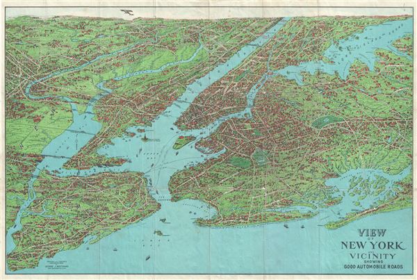
View of New York and Vicinity Showing Good Automobile Roads.
1929 (undated) 21 x 30 in (53.34 x 76.2 cm)
1929 (undated) 21 x 30 in (53.34 x 76.2 cm)
Description
This is an exceptional c.1929 birds-eye view map of New York City and vicinity by George J. Nostrand. Presented in chromolithograph color, this view reveals the five New York City Boroughs of Manhattan, Brooklyn, Queens, Staten Island and the Bronx. The area covered runs from Westchester County to New York Harbor and from Bergen County in New Jersey east to Nassau County in Long Island. Swinburne Island and Hoffman Island, two artificial landfills in the Lower New York Bay, near South Beach, Staten Island are included.
This map, showing ' Suburban Communities, Harbors, Water-Ways, Leading Streets, Avenues & Highways,' also notes major roads, piers, bridges, ferry routes, rivers, neighborhoods, waterways, beaches, islands and beautifully rendered topography in the vicinity of New York City. Individual landmarks, buildings and bridges are illustrated throughout. Important landmarks and monuments including the Statue of Liberty, Ellis Island, Grand Central, Madison Square Garden, Museum of Natural History, Metropolitan Museum of Art, etc. are identified. The harbor is full of ships while an airplane is seen flying in the sky.
Although the view is not dated, the mapping of the proposed Hudson River Bridge (constructed between 1927and 1931), which later became the George Washington Bridge, as well as the proposed Goethals Bridge (constructed between 1925 and1928) help date this map to the late 1920s. View maps such as these were quickly becoming unpopular in the first half of the 20th century. As flying became more and more popular, these imaginative hand-drawn panoramic views, which combined the information from earlier city plans and drawing, were being succeeded by aerial photography.
This map was most likely based on an earlier 1902 map by August R. Ohman, whose office was in the same building as Nostrand until 1925. This particular view was copyrighted, engraved and published by George J. Nostrand, 258 Broadway, New York City.
Condition
Very good. Minor wear and toning along original fold lines. Minor creasing. Professionally flattened and backed with archival tissue.