
This item below is out of stock, but another example (left) is available. To view the available item, click "Details."
Details
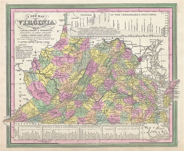
1846 Mitchell Map of Virginia and West Virginia
1846 (dated) $250.00
1846 Mitchell and Burroughs Map of Virginia with West Virginia (First Edition)
Virginia-mitchell-1846$150.00

Title
A New Map of Virginia with its Canals, Roads and Distances from place to place, along the Stage and Steam Boat Routes.
1846 (dated) 12 x 15 in (30.48 x 38.1 cm) 1 : 2000000
1846 (dated) 12 x 15 in (30.48 x 38.1 cm) 1 : 2000000
Description
This is a scarce first edition example of S. A. Mitchell and H. N. Burrough's 1846 map of Virginia, including West Virginia. This hand colored lithographic map predates the 1862 separation of Virginia and West Virginia, and so contains both modern states in full as well as parts of adjacent Kentucky, Ohio, Maryland, and North Carolina. A list in the map's lowers left quadrant shows various steamboat routes, along with mileage.
The Chesapeake Bay in particular, in rendered in full while a profile in the upper right details the elevations of the important Chesapeake and Ohio Canal. Operated until 1924, the Canal, which paralleled the Potomac connected the Atlantic to the Ohio River, and was a vital artery for trade between the populous Atlantic coast and the rapidly developing American interior.
This is a rare transitional map produced by the mysterious engraver H. N. Burroughs, whose work for the Mitchell firm appears in 1846 between that of H.S. Tanner and Mitchell himself. Ristow notes, 'Nothing is known about Burroughs, but he was undoubtedly an employee or associate of Mitchell.' His fine and detailed work appears only in the hard to find 1846 edition of the Mitchell's Atlas. Dated and copyrighted 'Entered according to Act of Congress in the year 1846, by H. N. Burroughs in the Clerks Office of the Eastern District of Pennsylvania.' Issued as plate no. 17 in the 1846 edition of Mitchell's New General Atlas.
CartographerS
Samuel Augustus Mitchell (March 20, 1792 - December 20, 1868) began his map publishing career in the early 1830s. Mitchell was born in Bristol, Connecticut. He relocated to Philadelphia in 1821. Having worked as a school teacher and a geographical writer, Mitchell was frustrated with the low quality and inaccuracy of school texts of the period. His first maps were an attempt to rectify this problem. In the next 20 years Mitchell would become the most prominent American map publisher of the mid-19th century. Mitchell worked with prominent engravers J. H. Young, H. S. Tanner, and H. N. Burroughs before attaining the full copyright on his maps in 1847. In 1849 Mitchell either partnered with or sold his plates to Thomas, Cowperthwait and Company who continued to publish the Mitchell's Universal Atlas. By about 1856 most of the Mitchell plates and copyrights were acquired by Charles Desilver who continued to publish the maps, many with modified borders and color schemes, until Mitchell's son, Samuel Augustus Mitchell Junior, entered the picture. In 1859, S.A. Mitchell Jr. purchased most of the plates back from Desilver and introduced his own floral motif border. From 1860 on, he published his own editions of the New General Atlas. The younger Mitchell became as prominent as his father, publishing maps and atlases until 1887, when most of the copyrights were again sold and the Mitchell firm closed its doors for the final time. More by this mapmaker...
Horatio Nelson Burroughs (June 28, 1812 - August 23, 1896) was an engraver and later a banker based in Pennsylvania and active in the early 19th century. He was born in Washington Crossing, New Jersey. Burroughs' work first appears in conjunction with Henry Schenk Tanner and Samuel Augustus Mitchell (the elder). His name appears on the 1846 copyrights of many of Mitchell's earliest and most important atlas and pocket maps. Following 1846, Burroughs retired from engraving to become a banker, eventually becoming president of Commonwealth Bank. He married first Eleanor Douglas Mitchell (18?? - 1853), then, after her untimely death, her sister Caroline Mitchell (1818 - 1892), both daughters of map and atlas publisher Samuel Augustus Mitchell Sr. (1792 - 1868). Learn More...
Source
Mitchell, S., A New Universal Atlas Containing Maps of the various Empires, Kingdoms, States and Republics Of The World, 1846.
Condition
Very good. Minor overall toning. Blank on verso.
References
Rumsey 0537.018. Philips (Atlases) 6103.