1796 Reid / Tanner Map of Virginia
Virginia-reid-1796$1,300.00

Title
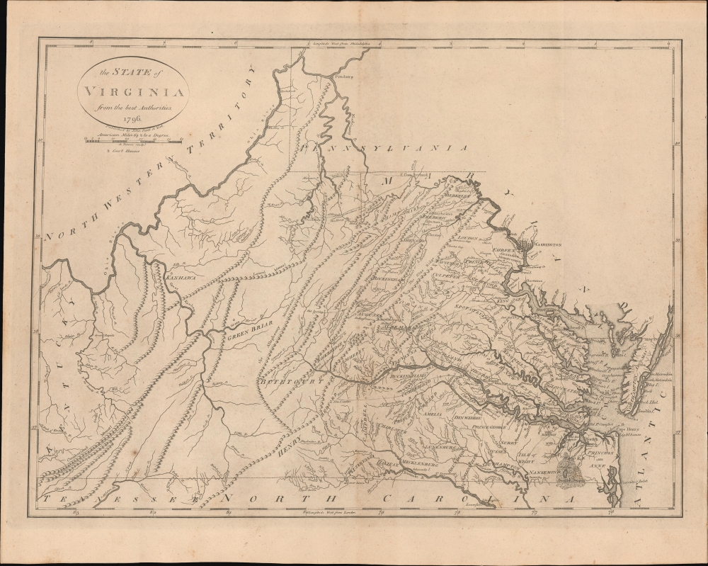
The State of Virginia from the best Authorities. 1796.
1796 (dated) 14 x 19 in (35.56 x 48.26 cm) 1 : 1647360
1796 (dated) 14 x 19 in (35.56 x 48.26 cm) 1 : 1647360
Description
This is John Reid's 1796 map of the state of Virginia, engraved by Benjamin Tanner for Reid's An American Atlas. It was only the second atlas map of Virginia published in the United States and is one of the earliest obtainable maps of Virginia as a U.S. state.
This map is especially notable for its early inclusion of Washington, D.C., still in a developmental phase. Nearby Georgetown, Alexandria, and Mount Vernon are also noted. The city of Pittsburgh, Pennsylvania, also makes an early appearance at top. In the years and months before this map's publication, the area around Pittsburgh and into northern and western Virginia was ground zero for the Whiskey Rebellion (1791 - 1794), a tense standoff over the limits of federal authority in the new republic.
A Closer Look
The map covers from the Ohio River in the west to the Chesapeake Bay in the east. Aside from Virginia, portions of Maryland, Pennsylvania, Kentucky, Tennessee, and North Carolina appear, along with a reference to the Northwest Territory across the Ohio River. Mountains and waterways are carefully detailed. Towns, courthouses, county names, Native American settlements, roads, and other features are labeled throughout. The eastern half of the state is covered in much greater depth, reflecting the concentration of people there and their relatively limited knowledge of the western frontier.This map is especially notable for its early inclusion of Washington, D.C., still in a developmental phase. Nearby Georgetown, Alexandria, and Mount Vernon are also noted. The city of Pittsburgh, Pennsylvania, also makes an early appearance at top. In the years and months before this map's publication, the area around Pittsburgh and into northern and western Virginia was ground zero for the Whiskey Rebellion (1791 - 1794), a tense standoff over the limits of federal authority in the new republic.
Publication History and Census
This map was engraved by Benjamin Tanner in 1796 for John Reid's An American Atlas. It was based on the map of Virginia engraved by Samuel Lewis that appeared in Matthew Carey's American Atlas the year prior (Rumsey 2542.013 and 2931.037), though there are subtle differences between the two. Aside from the Rumsey Collection, the Library of Congress and the American Antiquarian Society have independently cataloged a physical example, though facsimiles and digitized examples populate the OCLC, while the entire atlas is more widely distributed in institutional collections.CartographerS
John Reid (fl. c. 1775 - c. 1800) was an American bookseller and commercial mapmaker active in New York during the latter part of the 18th century. He is known for publishing the second American commercial atlas, the 1795 American Atlas. Unlike most American printers of his day, which were based in Philadelphia, Reid maintained his office at 106 Water Street, New York City. Little else is known of Reid's life and career. More by this mapmaker...
Benjamin Tanner (March 27, 1775 - c. 1846) was an American engraver active in the late 18th and early 19th centuries. Benjamin was the brother of the more prominent younger brother, the Philadelphia engraver Henry S. Tanner. Benjamin, who was based in New York City for most of his early career. Although is master is unknown, he most likely trained under the New York mapmaker Peter R. Maverick. His earliest work dates to 1792 and his is known to have engraved many of the maps for Reid's 1775 An American Atlas. Around 1811 he relocated to Philadelphia and established a business with his brother as a general engraver and map publisher. He also worked as a bank note publisher under the imprint of Tanner, Vallance, Kearny & Co. perfecting the stereographic technique until roughly 1846. Learn More...
Source
Reid, J., An American Atlas (John Reid: New York) 1796.
Condition
Very good. Light toning.
References
Rumsey 0845.014. OCLC 1452199189. American Antiquarian Society Maps2 Virginia 1796 001 F. Wheat, J. C. and Brun, C., Maps and Charts Published in America before 1800: A Bibliography, 572. Phillips (Atlases) 1366.