This item has been sold, but you can get on the Waitlist to be notified if another example becomes available, or purchase a digital scan.
1647 / 1661 Dudley Chart of Chespeake Bay, Virginia, Carolinas
VirginiaCarolina-dudley-1647$17,500.00

Title
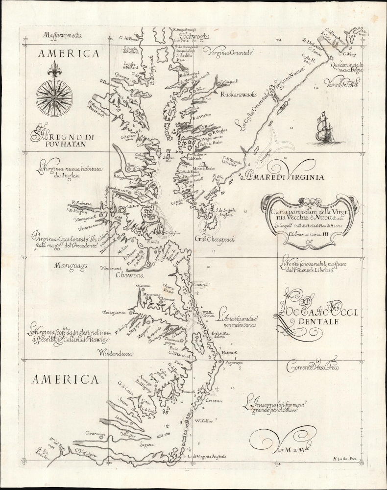
Carta particolare della Virginia Vecchia e Nuoua : la longitune comica da l'Isola di Pico di Asores : d'America carta, III.
1647 (undated) 18.75 x 15 in (47.625 x 38.1 cm) 1 : 1001088
1647 (undated) 18.75 x 15 in (47.625 x 38.1 cm) 1 : 1001088
Description
A seminal chart, this is a superb 1661 example of Sir Robert Dudley's 1647 maritime map of the mouth of the Chesapeake Bay and the Carolina Sounds. In its first edition, this was the first printed nautical chart of that region. As per the title, the chart depicts the coasts of 'Old and New Virginia,' meaning the colonial efforts of Sir Walter Raleigh and the Jamestown Colony, respectively. Due to the Virginia Colony's importance to the English, Dudley's chart focuses more sharply on the region than on his other North American charts.
In addition to depth soundings, the chart includes prevailing winds, ocean currents, and magnetic variations. As with all of the charts in Dudley's Dell'Arcano del Mare, this one is executed on the Mercator Projection, setting it among the first charts to be practical for actual navigation.
A Closer Look
The engraving charts the coastline from the area of Willis Landing and Cape Lookout in the south to Delaware Bay in the north. It thus includes Pamlico Sound and is the first chart to include depth soundings for that body. The upper limits of Chesapeake Bay run off the top of the chart, but the mouth of the Susquehanna River is noted. The cartography and most placenames are derived primarily from the 1590 John White and the 1612 John Smith maps, possibly through the intermediary of the Dutch publishers. Jamestown is marked and named. The placename to the south, Pto. Del Principe, can be found in Blaeu's 1638 Virginia Pars Australis and probably derives from the charts of Hessel Gerritsz. The text at the extreme south, Golfo Pericoloso, is not a Spanish place name, as some catalogers have assumed. This is an Italian descriptor, 'Dangerous Gulf'; it may reference Sir Richard Grenville's difficulties in his 1585 journey, which named Cape Fear. It is not beyond possibility that the name Golfo Pericoloso is the result of a mistranslation of Cape Fear. If this is the case, it goes towards explaining why 'Cape Fear' - the fifth oldest English place name in North America - does not appear on either of the Englishman Dudley's charts.In addition to depth soundings, the chart includes prevailing winds, ocean currents, and magnetic variations. As with all of the charts in Dudley's Dell'Arcano del Mare, this one is executed on the Mercator Projection, setting it among the first charts to be practical for actual navigation.
Publication History and Census
This map was completed by Sir Robert Dudley in manuscript form c. 1636. It was subsequently engraved in an Italian baroque style by Antonio Francesco Lucini and printed in Florence in 1647. According to Burden, it was not published until 1648, in the sixth volume of Dudley's Dell'Arcano del Mare. The present second-state example (exhibiting the notation 'Lº.6º.' in the cartouche) appeared in the 1661 edition of Dudley's nautical atlas. Four examples of the second state of this separate chart appear in institutional collections, comparable with four examples of the 1647 first state.CartographerS
Sir Robert Dudley (August 7, 1573 - September 6, 1649) was an English explorer and cartographer, the publisher of the Dell’Arcano de Mare, one of the greatest nautical atlases of all time. He was the illegitimate son of Robert Dudley, 1st Earl of Leicester (a favorite of Queen Elizabeth I) and Douglas Sheffield, the widow of John Sheffield, 2nd Baron Sheffield. In 1594, Dudley led an expedition across the Atlantic, with the intent of harassing Spanish merchantmen. His expedition met with a series of misfortunes, but successfully returned to England the following year. In 1596, Dudley joined an expedition led by Robert Devereux, 2nd Earl of Essex, against Cadiz. He served as the commander of the Nonpareil, and was knighted for his conduct in the capture of Cadiz. In 1603, Dudley made an attempt to establish his legitimacy at court and gain several inheritances, after being (possibly erroneously) informed that his parents had been secretly married. No concrete proof of the marriage could be furnished, thus the judgement was handed down against him in May 1605. Dudley left England in July of the same year, with his lover and cousin Elizabeth Southwell, who was disguised as his page. They married in Lyon in 1606 having received a papal dispensation. The couple settled in Florence, where Dudley began using his father’s title, Earl of Leicester, and his uncle’s, Earl of Warwick. In Florence, Dudley designed and built warships for the arsenal at Livorno and became a naval advisor to Ferdinand I, Grand Duke of Tuscany. In 1607, James I revoked Dudley’s travel license once ordered that he return to provide for his deserted wife and family. Dudley refused, was subsequently labeled an outlaw, and his estate was confiscated. By far Dudley’s most important work was the Dell’Arcano del Mare (Secrets of the Sea). His most celebrated achievement, is the atlas of sea charts of the world which accompanied the work. This maritime atlas was the first nautical atlas of the entire world in print, the first made by an Englishman, the first to show prevailing winds and currents, and the first to use the Mercator projection throughout. More by this mapmaker...
Antonio Francesco Lucini (January 1, 1610 - 1661), a.k.a. Anton, was an Italian engraver and printmaker. Lucini was born in Florence born in 1605. Lucini initially studied engraving with Stefano della Bella (1610 - 1664) under Jacques Callot (c 1592 - 1635), who lived in Florence from 1612 to 1621. He is recorded in 1616 as Callot's assistant in Florence. After 1621, he joined flowed Callot in Nancy to continue his training. He returned to Florence sometime before 1631, when he published a series of plates on the Great Siege of Malta. He is best known in cartographic circles as the engraver for Sir Robert Dudley's seminal maritime atlas Dell'Arcano del Mare (Of the Mysteries of the Sea), published in Florence in 1645 - 1646. The 200 engraved plates and 146 charts which Lucini produced for Dudley occupied 12 years occupied 12 years of his life and consumed some 5000lbs of copper. The engravings exhibit Lucini’s masterful craftsmanship and are outstanding examples of Italian Baroque engraving. Indeed, while Dudley was a master chartmaker, it is Lucini's virtuoso engraving and fine calligraphy that most define Dudley's work. Learn More...
Source
Dudley, R., Dell'Arcano del Mare, (Florence: Cocchini) 1661.
Dell’Arcano del Mare (Secrets of the Sea) is a six volume 17th century maritime encyclopedia by English nobleman Sir Robert Dudley (1573 - 1649). It is considered to be one of the most important maritime atlases of all time, the first of its kind in print: the first sea atlas to treat the entire world (not just Europe), the first by an Englishman, the first to illustrate prevailing winds and currents, and the first to universally employ a Mercator projection. The charts themselves are notable for being all new works, created by Dudley based upon a lifetime of collecting maritime data. All of the roughly 130 known charts in the Dell’Arcano del Mare were engraved in the Italian baroque aethetic by Antonio Francesco Lucini, a Florentine master engraver. It is said that the work took Lucini 12 years and consumed more than 5000lbs of copper. It was published in Florence between 1645 and 1646 in six folio volumes. Another edition was issued in 1661 but contained fewer charts.
Condition
Excellent. Few gentle creases; faint soiling in margins, else fine condition.
References
OCLC 431583083. Burden, P., The Mapping of North America, #279 state 2. Cumming, W., The Southeast in Early Maps, 44. Wooldridge, W., Mapping Virginia: From the Age of Exploration to the Civil War, #145.