This item has been sold, but you can get on the Waitlist to be notified if another example becomes available, or purchase a digital scan.
1781 Bellin Map of the Chesapeake Bay and Surrounding States
VirginiaChespeack-bellin-1781$187.50

Title
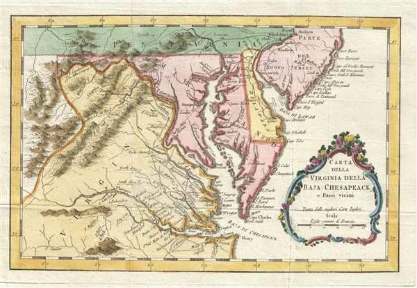
Carta della Virginia della Baja Chesapeack e Paesi vicini.
1781 (undated) 7.25 x 11.25 in (18.415 x 28.575 cm) 1 : 2400000
1781 (undated) 7.25 x 11.25 in (18.415 x 28.575 cm) 1 : 2400000
Description
This is a rare 1781 Italian edition of French cartographer Jacques-Nicholas Bellin’s 1757 map of the Chesapeake Bay including Virginia, Maryland, Delaware and parts of New Jersey and Pennsylvania. Bellin's map covers from Cape Henry north to the Susquehanna River and Burlington, New Jersey and inland as far as the Appalachian Mountains. The Chesapeake Bay is shown in full, as are many of its river estuaries. The map notably includes the Chesapeake Bay's western watershed, luring potential colonists with the promise of large navigable rivers and rich fertile lands.
In the title cartouche Bellin cites that this map is derived from the 'best English maps' (Turee des Meilleures Cartes Angloises). In this he can only be referring to the Fry-Jefferson map of 1753. Such is apparent from the cartographer's inclusion of Moulin Hoggats (Hoggett's Mill) on the upper Appomattox River. This mill first appeared on the Fry-Jefferson map and did not subsequently reappear on another published map until the present issue.
Bellin prepared this map for issue in the 1757 French edition of Provost's Histoire Generale des Voyages. The present example is the first edition, identifiable by the right hand pointing to a note just below the title cartouche. There were five editions of this map as well as several variant states.
Cartographer
Jacques-Nicolas Bellin (1703 - March 21, 1772) was one of the most important cartographers of the 18th century. With a career spanning some 50 years, Bellin is best understood as geographe de cabinet and transitional mapmaker spanning the gap between 18th and early-19th century cartographic styles. His long career as Hydrographer and Ingénieur Hydrographe at the French Dépôt des cartes et plans de la Marine resulted in hundreds of high quality nautical charts of practically everywhere in the world. A true child of the Enlightenment Era, Bellin's work focuses on function and accuracy tending in the process to be less decorative than the earlier 17th and 18th century cartographic work. Unlike many of his contemporaries, Bellin was always careful to cite his references and his scholarly corpus consists of over 1400 articles on geography prepared for Diderot's Encyclopedie. Bellin, despite his extraordinary success, may not have enjoyed his work, which is described as "long, unpleasant, and hard." In addition to numerous maps and charts published during his lifetime, many of Bellin's maps were updated (or not) and published posthumously. He was succeeded as Ingénieur Hydrographe by his student, also a prolific and influential cartographer, Rigobert Bonne. More by this mapmaker...
Source
Bellin, N., Teatro della guerra marittima, e terrestre fra la Gran Bretagna, le Colonie Unite, la Francia, la Spagna, ed Olanda… (Venice) 1781.
Condition
Very good. Blank on verso.
References
OCLC 867606519.